

Nepal earthquake: Landslide threat in coming weeks high in many locations says assessment
The mountainous area along the Nepal-Tibet border, north of Kathmandu and west of Mount Everest, directly above the fault line is at high risk of landslides and mudslides in coming weeks and months.
The risks will increase with monsoons that arrive in summer, according to a scientific study.
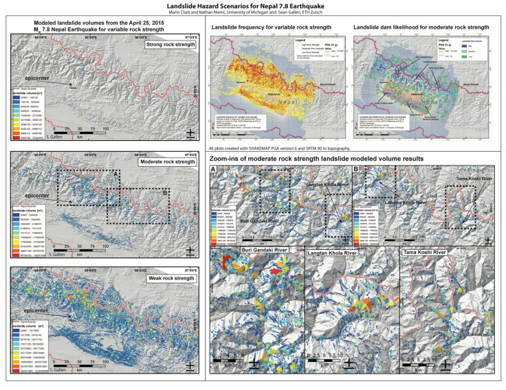
University of Michigan geomorphologist Marin Clark and two colleagues who assessed the landslide threat in Nepal following the 25 April magnitude-7.8 earthquake found thousands of locations at high risk in coming weeks and months.
"The majority of them we expect have already happened and came down all at once with the shaking on Saturday," Clark said. "But there will still be slopes that have not yet failed but were weakened. So there will be a continued risk during aftershocks and with the recent rainfall, and again when the monsoon rains arrive this summer."
The highest-risk zone is at elevations above 8,200 feet in a region that covers almost 45,000sq km.
Remote villages are scattered throughout the high-risk zone, which is also popular with trekkers and mountaineers.
Clark expects many villages in the region are likely cut off from the rescue operation due to landslides.
With the season best suited for trekking and mountaineering, a large number of foreign tourists could be trapped in the area.
Landslides can also result in dam like structures that block water and have the potential for catastrophic flooding.
"With the satellite images, we'll be looking first at the highest-risk landslide areas that are close to big rivers," Clark said. "Those locations are high priorities."
Cloud cover over much of the region since the earthquake has blocked satellite observation but news reports of landslides in Nepal's Gorka district and Langtang Valley match with the U-M assessment.
Information from the U-M-led study has been shared with the US Geological Survey, Nasa, the US Agency for International Development and other responding agencies.
The assessment was based on a computer analysis that looked at earthquake shaking, slope steepness and the strength of various rock types.
More than 200,000 landslides occurred following a magnitude-7.9 earthquake in a mountainous region of Sichuan Province, China, in 2008, according to Clark.
This had hampered response and recovery efforts. The death toll was about 70,000.
Landslide refers to a slow to very rapid descent of rock and debris while a mudslide is a fluid mix of mud and debris flowing down.
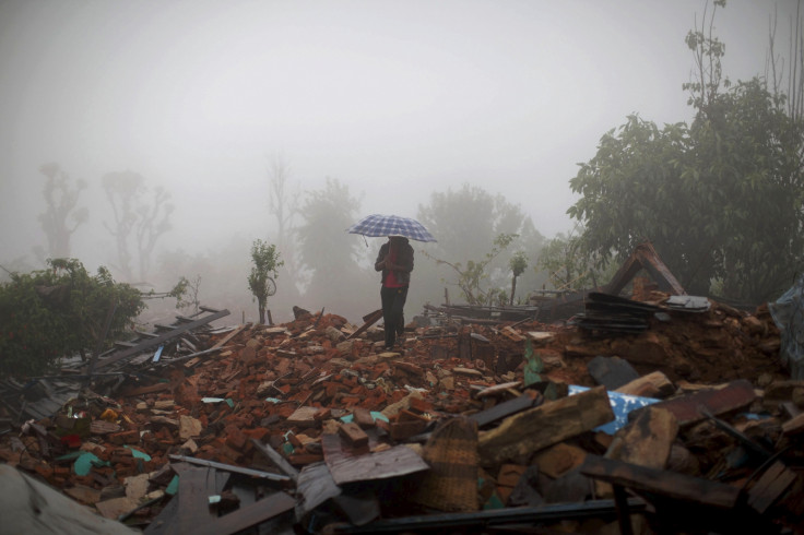
The toll from the present earthquake is expected to cross 10,000.
© Copyright IBTimes 2024. All rights reserved.
-

Billionaire Declared Missing And Dead In 2018 Is 'Possibly Living In Moscow With Mistress'
-

Wendy's Sued For $20M After 11-Year-Old Gets Brain and Kidney Damage From 'Dirty Meal'
-

EU Sanctions Policy Is Attracting Growing Controversy
-

Russian Blogger Starved Son To Death By Only 'Feeding Him Sunlight' Instead Of Food


