

Nasa Satellite Video Tracks Tornadoes Ravaging US

Nasa has released an animation of visible and infrared satellite data from the National Oceanic and Atmospheric Administration which shows the tornadoes and lethal storms that swept across the US at the beginning of the week.
Taken from NOAA's GOES-East satellite, the clip shows the development and movement of the weather system that spawned tornadoes affecting seven central and southern states. Nasa's Aqua satellite also captured infrared data on the system that revealed powerful storms, reaching high into the troposphere, the lowest portion of the Earth's atmosphere.
The animation begins on 27 April at 00:15am UTC (26 April at 8:15pm EDT) and runs through to 28 April at 2:15pm UTC (10:15am EDT).
Intense storms have ravaged the region since Sunday night when a swarm of tornadoes tore through Nebraska, Kansas, Iowa, Oklahoma, Arkansas, Louisiana, and Mississippi. According to Reuters, the tornadoes have killed at least 21 people.
Devastating footage showed upended cars, downed power lines and extensive building debris. The tornadoes tore through hundreds of homes and businesses in communities that are still recovering from a strong storm system that left 316 people dead in May 2011.
The northern Mississippi towns of Tupelo and Louisville were badly hit by the recent storms. "It's a very serious situation," the Tupelo mayor, Jason Shelton, told the Guardian. "I am just encouraging everyone to stay inside and be weather aware. There is still a very real danger of another line coming through and people still need to be inside."
The GOES-East satellite sits in a fixed orbit in space and captures imagery of weather of the eastern US and Atlantic Ocean.
To create the video and imagery, NASA/NOAA's GOES Project took cloud data from NOAA's GOES-East satellite and overlayed it on a true-colour image of land and ocean created by data from NASA's Aqua and Terra satellites.
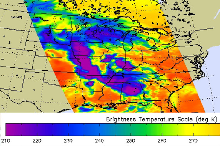
A NASA satellite also captured an image of the storm, collecting infrared data on it as it passed overhead. The data was gathered by the Atmospheric Infrared Sounder (AIRS) instrument that flies aboard the satellite.
The AIRS image showed very cold cloud top temperatures indicating that the thunderstorms had strong uplift that pushed cloud tops to the top of the troposphere. Some of those thunderstorms had cloud tops as cold as 200 Kelvin, which is around -73.1C.
"AIRS data shows spatial extent of strong convection [rapidly rising air that condenses and forms clouds] in the slow-moving severe storm system that spawned tornadoes in Arkansas, Oklahoma and Iowa," said Ed Olsen, creator of the AIRS image at NASA JPL.
According to CBS News, the largest tornado touched down near Little Rock, Arkansas at around 7pm (local time) on Sunday night. Reported to be half a mile wide, it stayed on the ground for 80 miles and passed near several suburbs north of the city.
The same weather system may bring the severe weather further east, from Cincinnati in Ohio to New Orleans, Louisiana. More information can be found at NOAA's Storm Prediction Center website or at the National Weather Service Twitter account.
The National Weather Service has warned of the possibility of more dangerous winds, along with baseball-sized hail. "This is a multi-day event and today is the second day of significant tornado risk and unfortunately, probably not the last," Bill Bunting, operations chief at the Storm Predictions Center, told Reuters.
© Copyright IBTimes 2024. All rights reserved.
-

Football Clubs With The Most Arrests And Bans in 2022-23
-

Oil Prices Slip As Investors Eye Israel's Response To Iran Strike
-

Billionaire Declared Missing And Dead In 2018 Is 'Possibly Living In Moscow With Mistress'
-

Wendy's Sued For $20M After 11-Year-Old Gets Brain and Kidney Damage From 'Dirty Meal'


