

World Wetlands Day 2016: Satellite images offer fascinating look at Earth's most precious resource – water

World Wetlands Day is celebrated every year on 2 February, the date in 1971 that the Convention on Wetlands was adopted in the Iranian city of Ramsar. Wetlands are areas of land that are permanently or seasonally saturated with water. They are vital environments for their often unique plant and animal life.
To celebrate World Wetlands Day 2016, the European Space Agency has published satellite images of eight wetlands around the world. The images and data gathered by Earth-observing satellites from their vantage point of 800 km high can be used to monitor and sustainably manage these precious resources.
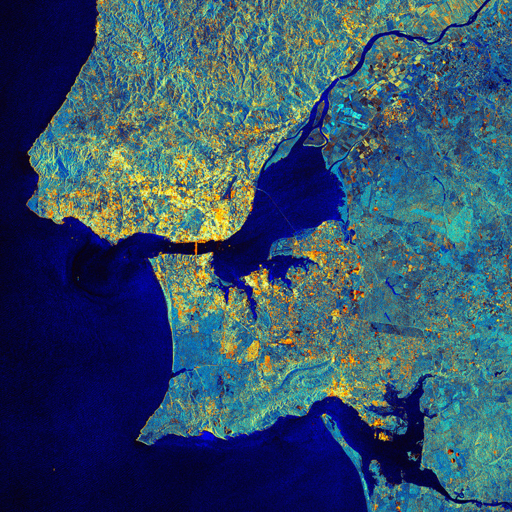
The image below shows the Portugal's capital, Lisbon. Flowing in from the upper-right corner is the Tagus River. Originating in central Spain and emptying into the Atlantic Ocean at Lisbon, the Tagus is the longest river on the Iberian Peninsula, at over 1,000km. Its estuary – visible at the centre of the image – is a natural reserve and a Wetland of International Importance, as designated in the Ramsar Convention. With extensive mudflats, saltmarshes, reedbeds and human-made salt pans, the area is important for around 16 species of wintering or staging waterbirds, numerous species of breeding birds, and the European otter.
Lisbon city centre on the northern shore of the Tagus is visible by bright radar reflections from buildings and other structures. We can also see the reflections from the suspension bridge that connects Lisbon to Almada on the southern shore. Further east is the Vasco da Gama Bridge, the longest in Europe, at 17.2 km.
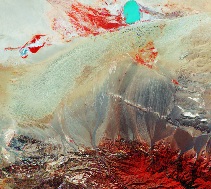
This false-colour image [below] features southern Mongolia, bordered by China to the south and Russia to the north. Mongolia sits deep within eastern Asia, far from any ocean. It is home to the Gobi – Asia's largest desert and the fifth largest in the world.
At the bottom of the image is part of the Baga Bogd Mountain range. Low vegetation is present here during the warm month. This, along with some scattered trees, gives the red tones that we see in the image. Varying tones of red represent types of vegetation and varying density and condition of the plants. The sharp image reveals patterns where eroded soil, with the help of rain, is carried from the mountain slopes to lower lands.
There is a very distinct body of water towards the top right part of the image, the Taatsiin Tsagaan Lake, one of the four saline lakes that make up the Valley of the Lakes. Mongolia joined the Ramsar Convention on 8 April 1998, which covers Wetlands of International Importance. The lake's depth and high concentration of salt give the water a vivid turquoise colour.
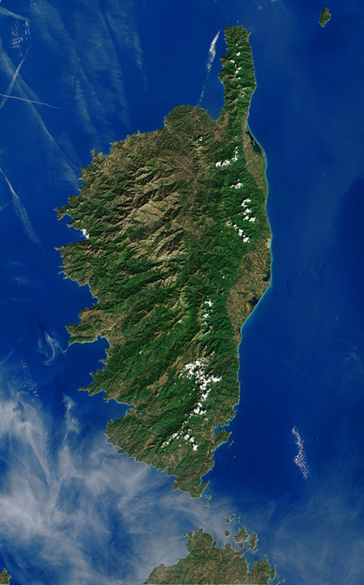
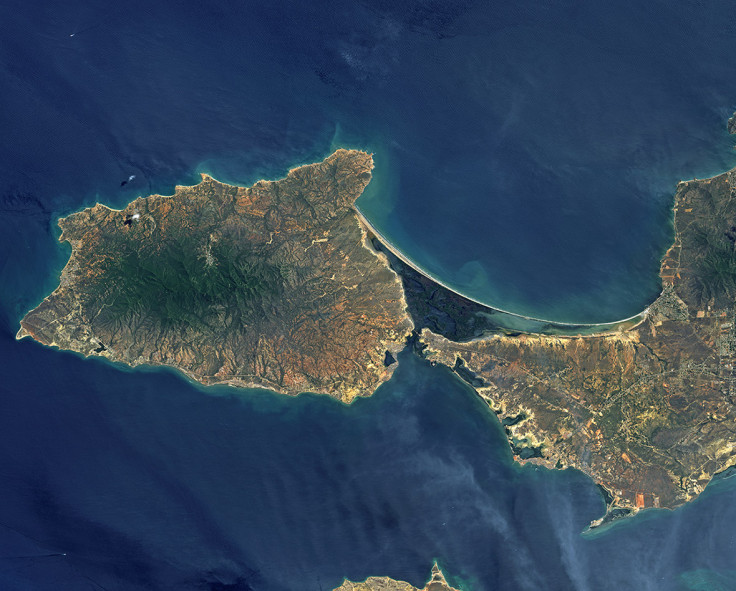
The Mediterranean's most mountainous island, Corsica, dominates this image [below] from the Landsat 8 satellite. About 40% of the island's surface area is dedicated to nature reserves, and its mountains are a popular destination for hiking. For beachgoers, the island boasts over 1,000km of coastline.
Near the north eastern coast we can see the island's largest coastal lagoon, the Etang de Biguglia. This nature reserve has been noted for its support of numerous breeding and wintering waterbirds, as well as the vulnerable Hermann's tortoise and long-fingered bat. This lagoon is one of the over 2,000 sites worldwide considered to be Wetlands of International Importance by the Ramsar Convention.
The Etang de Biguglia is not the island's only Ramsar site: further inland in the central-north part of the island is an active raised bog, home to a number of protected bat, reptile, bird and amphibian species. Other Ramsar sites on the island are two more coastal lagoons about halfway down the east coast, and a series of temporary pools in the south. These pools in the semi-arid granitic landscape are an uncommon geomorphological phenomenon in the region supporting a diversity of rare species.
Over the water in the upper-left section of the image we can see condensation trails, or 'contrails', from aircraft or ships. Contrails form when exhaust particles act as nuclei around which water condenses, resulting in elongated cloud-like trails that can last anywhere from minutes to hours. They can also form persistent, artificial cirrus clouds that can last for days or weeks, and can affect Earth's climate by trapping heat in our atmosphere.
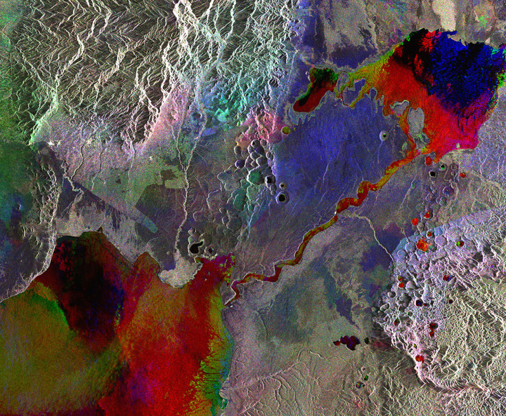
Lakes and mountains of western Uganda are captured in this Envisat radar image [below]. The area pictured is part of the Albertine Rift, a branch of the East African Rift where the Somali Plate is splitting away from the rest of the continent. In the upper right corner is Lake George, recognised as a Wetland of International Importance by the Ramsar Convention. Its waters flow into the Kazinga Channel – known for its high concentration of hippopotamuses and Nile crocodiles – and then empty into Lake Edward at lower left.
The colours in the two lakes and connecting channel indicate changes in water level between acquisitions. On either side of the channel, large craters and crater-lakes dot the volcanic fields. At the top of the image, we can see the foothills of the Rwenzori Mountains on the border between Uganda and the Democratic Republic of the Congo (west). Its mountain chain is home to numerous glaciers, waterfalls and lakes, and its highest peak tops 5,100m. However, climate change has negatively affected the glaciers, and subsequently the mountains' vegetation and biodiversity. To the south of the mountains, the bright pink, purple and green areas show where changes in the land's surface occurred between the three radar scans that make up this composite image. These changes are primarily in vegetation as the land here is blanketed with agricultural plots. There is even a clear-cut line where agricultural activities end and the protected land begins.
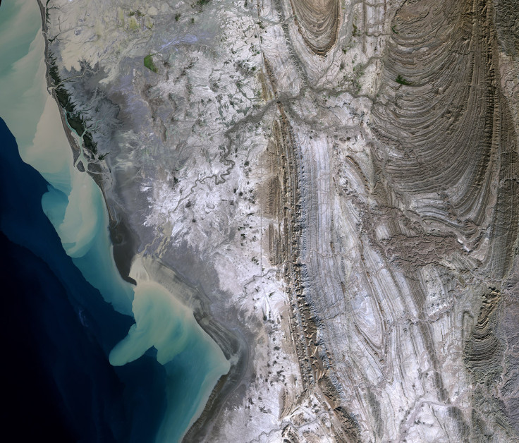
This satellite image [below] shows the Rud-e-Gaz and Rud-e-Hara wetlands, in a remote area in southern Iran . To the west is the Strait of Hormuz, between the Gulf of Oman to the south and Persian Gulf to the north. The brown areas along the coast are sediments carried from rivers that flow only after erratic rainfall in the interior, usually in the winter months.
The area pictured is extremely arid, as evident by the lack of vegetation. But in the upper left and slightly inland, we can see a green area that appears to be standing water from a human-made dam on the river.The dark zones along the coast are wetlands at the deltas of the Rud-e-Gaz and Rud-e-Hara rivers. This extensive complex of tidal mudflats, creeks, saltmarshes, mangroves, sandbanks and offshore islands is an important site for wintering waterbirds.This is just one of the over 2,000 sites worldwide considered to be Wetlands of International Importance by the Ramsar Convention.
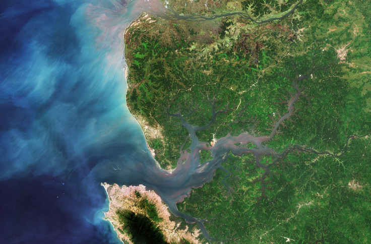
Part of Sierra Leone in West Africa is pictured [below]. The country's capital, Freetown, sits on a peninsula at the bottom of the image. Its economy revolves around its natural deep water harbour – one of the world's largest. Across the river, we can see the runways of the Lungi International Airport.
The area in the central-right portion of the image is the Sierra Leone River Estuary. The estuary is dominated by mangroves and lowland coastal plains and is an important breeding habitat for multiple waterbird species. Diverse socio-economic activities are supported by the estuary, such as fishing, tourism and sea transport, which help to alleviate poverty at the community level. However, the estuary is being threatened by a growing population. Unauthorised housing development has caused the removal of about 20 hectares of mangrove vegetation over the past five years alone. Poor waste disposal, unsustainable fishing and many other factors are also taking their toll on the ecosystem. Some 295,000 hectares of this estuary is protected under the Ramsar Convention.
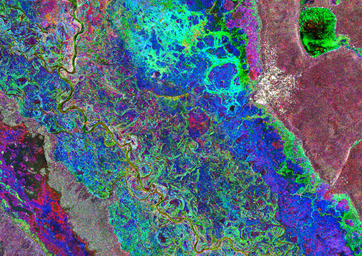
The image below shows the Zambezi River's floodplain in western Zambia. The city of Mongu appears as a cluster of white radar reflections on the right side of the image. It is about 15km from the river's main channel – which appears light green, snaking down the left side of the image – but during the wet season, the waters rise right up to the edge of the town.
This is a compilation of three Envisat images. Each is assigned a colour, and when they are combined they show changes between them. The images were acquired on 1 March 2011 during the wet season, and on 27 September and 26 December, when water levels were low. Combined, the psychedelic array of colours reveal how drastically the floodplain changes between seasons.
As the second largest wetland in Zambia, the Zambezi floodplain is a major spawning ground for fish. With about 80 different fish species, it serves as a source of livelihood to the local people, along with harvesting of other wetland resources like reeds and sedges for handicraft, and rice cultivation. However, this area is threatened by unsustainable fishing, animal poaching and the dredging of canals.
Finally, the image below shows Margarita Island, situated in the southern Caribbean Sea about 20km off of Venezuela's mainland coast. The island comprises two peninsulas linked by a long, narrow strip of land – called an isthmus. The eastern part of the island is home to most of the island's residents, while the Macanao peninsula to the west is dominated by a central mountain range.
Between the peninsulas, and cut off from the open sea by the isthmus, lies the La Restinga lagoon, a national park that appears as a dark green and blue area in this image. Recognised as a Wetland of International Importance by the Ramsar Convention, the area features picturesque mangroves and is an important feeding ground for birds such as herons and flamingos. The shallow waters are home to red snappers, sardines and swordfish – among other types of fish – and oysters grow on the mangrove roots.
© Copyright IBTimes 2024. All rights reserved.
-

Football Clubs With The Most Arrests And Bans in 2022-23
-

Oil Prices Slip As Investors Eye Israel's Response To Iran Strike
-

Billionaire Declared Missing And Dead In 2018 Is 'Possibly Living In Moscow With Mistress'
-

Wendy's Sued For $20M After 11-Year-Old Gets Brain and Kidney Damage From 'Dirty Meal'


