

Earthquake off the coast of Fiji triggers tsunami alert
The magnitude 6.9 quake struck just before 10pm GMT.

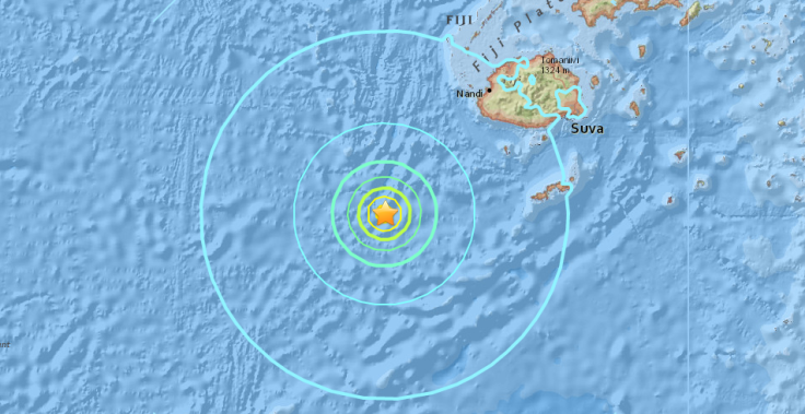
A magnitude 6.9 earthquake has struck off the coast of Fiji, triggering a tsunami warning. The quake was 10km deep and hit around 227km southwest of the island nation.
The Pacific Tsunami Warning Centre (PTWC) said that "hazardous tsunami waves" are forecast off the Fiji coast and called on government agencies and people to stay alert. Though initially reported as 7.2, the magnitude was later downgraded to 6.9 by the US Geological Survey.
The earthquake hit at 11:53am local time (9:53pm GMT). The PTWC estimated that the first wave could hit the Fiji coast at 22:25 UTC.
New Zealand's Civil Defence ministry said that there was "no tsunami threat to New Zealand following the 7.2m earthquake south of Fiji". Hawaii is also not threatened by a tsunami.
Reporters from Radio New Zealand have said that evacuations are occurring on Fiji's Nadi island but that residents do not seem to be hearing sirens or tsunami alerts.
Coastal residents in #Fiji are not hearing tsunami warnings https://t.co/Jl5f5hWJ0N
— Alex Perrottet (@alexperro) January 3, 2017
© Copyright IBTimes 2024. All rights reserved.
-

Lack Of Women's Rights Exposed In Iceland As It Tops WEF's Gender Gap Index 14 Years In A Row
-

Zelensky Now On Russia's Most Wanted List: Joins a US Senator, Estonia's PM and Almost 100,000 More
-

US Christian Couple Start Anti-Woke School Designed Around 'Traditional American Values'
-

US Couple Donates $121M To Help Fund College Scholarships at a Ohio University, but There's a Catch


