

'Doorway to the underworld' crater in remote Siberia tells story of ancient climates
Team hopes ancient sediments revealed by expanding craters can teach us about what region's ecosystem looked like.

It has sometimes been nicknamed "doorway to the underworld" and locals tend to stay away from it, but the Batagaika crater, located in the Yana river basin in eastern Siberia, fascinates scientists from around the world.
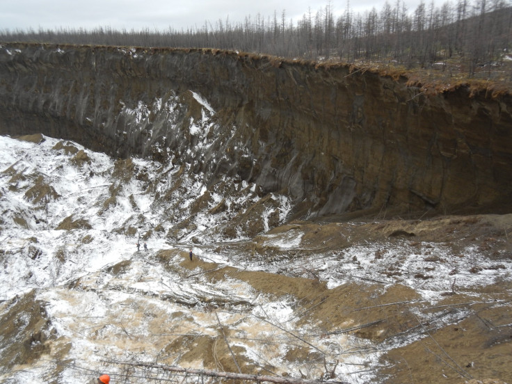
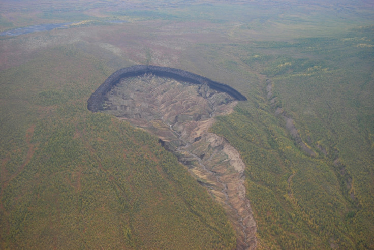
Craters like this one are known by geologists as 'slumps', with the largest (more than 5 hectares in area) referred to as 'megaslumps'. The Batagaika crater is the largest of them all, exceeding 50 hectares in area. It is also 86m deep.
Slumps and megaslumps are scattered across Siberia, Alaska and Canada. As the climate continues to warm the thawing of permafrost in these regions accelerates, making them grow bigger and bigger.
Russian and German scientists are currently monitoring Batagaika to see how fast it is expanding, but another team, led by Julian Murton from the University of Sussex, has taken a different approach in its study of the site.
The researchers are looking at what the megaslump can tell us about the history of ancient climates and what Siberia looked like thousands of years ago. Their findings from a first reconnaissance study were published in February.
When and why did the Batagaika crater form?
The crater began in the 1960s when locals cut down some trees in the area. Because trees shade the soil from the summer heat, this had the effect of increasing the amount of heat entering the soil. Trees also transpire, which has the effect of cooling the soil, so when their number was reduced, this had an impact on the soil's temperature. The permafrost started thawing from the top down.
There was a gully that extended down a slope, it started deepening soon after the trees were cut down and the permafrost started to melt, leading to the creation of the megaslump.
Murton told IBTimes UK: "The formation of the megaslump was triggered by human disturbance but it's symptomatic of climate warming – where the climate warms you get more permafrost thawing. This occurred at the end of the last Ice age and previous Ice Ages".
What are the consequences of the crater's expansion?
Monitoring of the megaslump only started a few years back. In the last two decades, there hadn't really been any kind of surveillance system in place, even though satellite images clearly show that since the 1960s, it has expanded dramatically. However, scientists haven't yet been able to calculate at what rate it is expanding.
As it gets wider, the landscape collapses by about 50 or 60 metres and the original forest disappears. New, highly gullied terrains have developed at the bottom of the slump.
These terrains are what geologists call "badland". In the south west of the USA you have examples of these very triangular, irregular slopes developed by rapid water erosion. It is thought these badlands will develop extensively at the bottom of the megaslump.
So as the megaslump expands, the original fairly smooth forested hills disappear to be replaced by this gullied, irregular topography.
What kind of sediments have been exposed by the expanding crater?
Murton explains that the goal of his team's work at the crater is to look the region's geological history and to reconstruct it by sampling frozen permafrost.
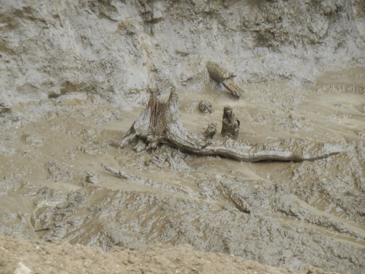
About five layers of sediment have been exposed by the expanding megaslump. They are comprised of ice and a lot of frozen sand. There were also a couple of wood-rich layers that represent former forests.
"Our work so far has just been reconnaissance. We identified what the layers are and did a bit of reconnaissance sampling to radiocarbon date organic material, things like roots and wood in the sequences, to give us some indication of their age", Murton explained.
What can the crater tell us about past climates?
These layers can take them back to 125,000 years ago in their study of past climate – this is the last period in geological time when the climate in the Arctic was substantially warmer than it is now, by a few degrees.
"We may even be able to go back to 200,000 years, but there is still a bit of uncertainty in the dating, we need to do more work at the site. One hypothesis is that the lower wood layer represents an ancient forest that developed about 200,000 years ago", Murton added.
The scientists also looked some of the sand grains to understand what processes deposited them – finding evidence for past windy climates, with a lot of wind having blown and deposited the sand around.
If they get sufficient funding, they want to do some drilling to get a continuous sequence, a core of frozen permafrost extending throughout the deposit. They would then like to do high-resolution analysis of the sediment to develop a clearer picture of what climates looked like over the last 125,000 to 200,000 years.
How can this work help us to understand future climate change?
The climate is warming particularly rapidly in the Arctic. The scientists want to reconstruct past climates and environments, for example from 125,000 years ago, to understand what the region looked like when it was warmer than it is now – as it will potentially be in the future.
"If you know what the ecology was, what the plants and animals were in this part of the Arctic, this can give us some indication of what it may be in the future as climate continues to warm or what some of the vegetation responses we may see in the landscape," Murton concluded.
© Copyright IBTimes 2025. All rights reserved.
- MOST READ


