

How Ford teaches autonomous cars to drive on snow-covered roads

Ford is the first company to publicly show off its autonomous cars driving themselves in the snow. Now, as Google expands its own autonomous project in search of bad weather, Ford has revealed how the technology works – and how it captures 600GB of 3D map data every hour.
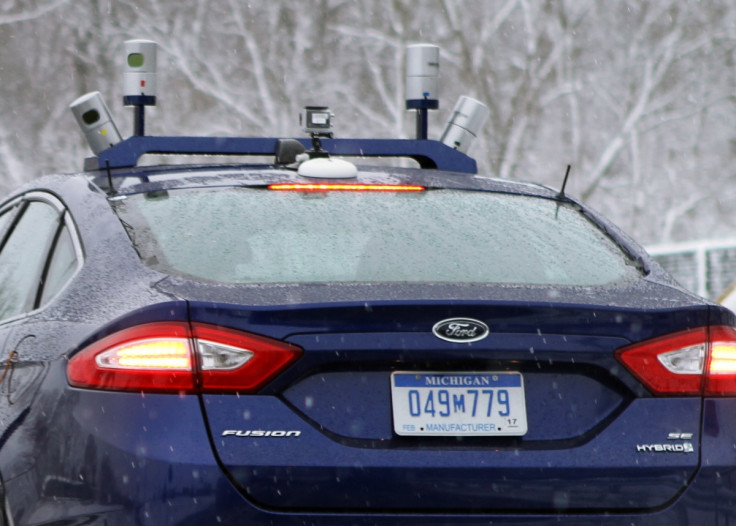
The fleet of specially modified Ford Fusions (sold as the Mondeo in the UK), mostly rely on LiDAR sensors to scan their environments and stay on course when snow makes it difficult for regular cameras to see road markings and other traffic. But the cars can't drive on any snow-covered road just yet, because first they need to have driven the road in good weather conditions.
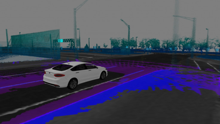
Doing this, the car uses LiDAR to build up a map of what the road looks like and where buildings, trees, junctions are other street pieces of furniture are. The four sensors beam out 2.8 million laser points every second, which bounce off the surroundings and help to give the car a highly accurate maps of what the street looks like.
By comparing the live and recorded maps, the car can accurately locate itself to within a centimeter. For comparison, GPS is accurate to around nine meters, a distance 900 times greater.
Later, when the roads are covered in snow, the car can use its LiDAR sensors again to monitor its surroundings and compare them to the map recorded in good weather. That way, even when markings are obscured by snow and kerbs are hidden behind snow drifts, buildings and other objects can be compared between the stored map and the car's live view.
These LiDAR sensors create an enormous amount of data. Every hour, Ford's autonomous car collects up to 600GB of data, which it uses to make a high-resolution 3D map of the landscape. This is enough data to keep the average UK smartphone user happy for 23 years, based on an average monthly use of 2.2GB, as stated by BroadbandChoices in June 2015.
Ford also claims the LiDAR sensors are so powerful, they can map individual raindrops and snowflakes as they fall around the car. While clever, this would also cause havoc as the car would treat each flake as an obstacle to avoid driving into. To stop this happening, Ford has worked with researchers from the University of Michigan to create an algorithm that recognises precipitation and filters it out of the car's field of vision.
Although Ford says its autonomous cars can drive themselves with one defective sensor, the company recognises that "eventually, the cars might be able to handle ice and grime buildup themselves through self-cleaning or defogging measures."
Ford's snow driving takes place in Michigan, mostly at Mcity, a purpose built 32-acre real-world driving environment. The area features streets lines with mock-up shops, junctions and traffic lights, and can be filled with other (controlled) traffic to help teach autonomous cars how to share the roads with each other and, importantly, with pedestrians, cyclists and human drivers.
© Copyright IBTimes 2024. All rights reserved.
-
Doug McMillon Unloaded Walmart Trucks For $6.50/Hour In 1984, Now He's The CEO
-

How Are Female Tech Firms Fighting the Employment Crisis in the West Bank?
-

Italian PM Has British Newborn With Heart Defects Airlifted to Rome for Treatment Unavailable in UK
-

Sugar Baby Gets 9 Years In Jail For Scamming $1M From Men And Selling How-to Manuals


