

Hurricane Dorian: Storm weakens and stalls north of Bahamas
Hurricane Dorian has weakened to become a category 3 storm and has stalled in the north of the Bahamas.
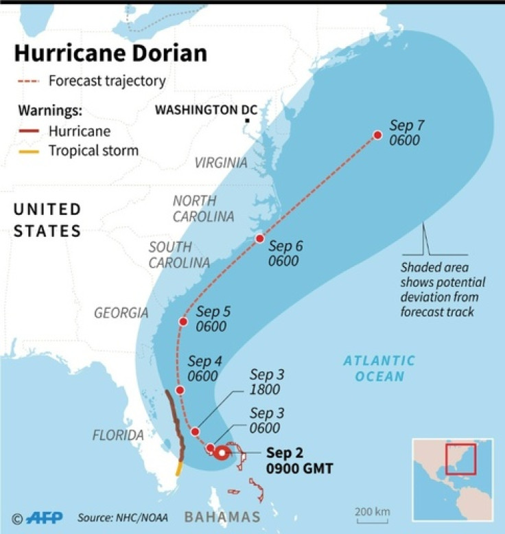
After lashing through the Bahamas as a category 5 hurricane, the intensity of Hurricane Dorian has reduced to a category 3. While it is expected to move towards Florida late on Tuesday night or early Wednesday morning, the storm continues to hover just north of the Bahamas. The northern Bahamian islands are to get heavy rains which might result in life-threatening floods. The floods have also been preventing the initiation of search and rescue work.
Hurricane #Dorian has barely moved over the last 24 hours, continues to hammer Grand Bahama Island. Still a CAT 3 with 120 mph max sustained winds. pic.twitter.com/chQ9OyCeKY
— NWS Paducah (@NWSPaducah) September 3, 2019
The Island of Abaco and Great Bahama have already been flooded by the constant rain brought by the hurricane. As the storm continues to stall near Great Bahama Island, it continues to get 30 inches (76cm) of rain. According to The Independent, Bahamian Prime Minister Hubert Minnis has called the hurricane a "historical tragedy" and the damages caused by the storm is "unprecedented and extensive."
On Monday, only one death had been reported in the area. The official death toll in the Bahamas stands at five as of Tuesday. Since the storm continues to disrupt communication and rescue efforts, the official extent of damages to property and life remains unclear.
People residing near the coast of Florida, Georgia and South Carolina are being evacuated. The speed of the storm has reduced to around 120 mph (193kmh) wind speeds. Fort Lauderdale, Palm Beach, and Orlando international airports are a few of the airports which have been shut down ahead of the storm's approach. Over a thousand flights have been redirected from the east coast states.
Rain has started battering many parts of Florida.
Gusty outer bands of #Dorian continue this morning along Florida's treasure coast - check out the rain in #FortPierce #FL 📽ï¸: @MadelineTV @CBS12 pic.twitter.com/5Mqt3yH4DE
— WeatherNation (@WeatherNation) September 3, 2019
According to the National Hurricane Centre, the storm will reach the coast of Florida late on Tuesday night. After hitting Florida, it will make its way up the coast touching Georgia, South Carolina and North Carolina over Wednesday and Thursday. Even though the intensity of the tornado has reduced, it could pick up again as it approaches the US coast.
US President Donald Trump's property, Mar-a-Lago Club, prepared for the storm by barring the doors and windows with storm shutters. Trump tweeted about the devastation caused by the storm in the Bahamas. However, as the storm approaches his country, the President has been spotted at a golf club in Virginia. Having canceled his trip to Poland due to the approaching storm, Trump was spotted playing golf. Trump also drew criticism for wrongly claiming that Alabama might be affected by the storm, which was refuted by weather reporters.
Spotted by eagle-eyed photojournalist @abdallahcnn: Trump golfing at his Virginia golf club moments ago pic.twitter.com/0DwVtGmvGN
— Jeremy Diamond (@JDiamond1) September 2, 2019
© Copyright IBTimes 2024. All rights reserved.
-

Doug McMillon Unloaded Walmart Trucks For $6.50/Hour In 1984, Now He's The CEO
-

Utah Couple Doesn't Know Cat Jumped Into Amazon Package, Accidentally Ships It to California
-

How Are Female Tech Firms Fighting the Employment Crisis in the West Bank?
-

Italian PM Has British Newborn With Heart Defects Airlifted to Rome for Treatment Unavailable in UK


