

Hurricane Ophelia could soon reach Europe
Ophelia is the 10th consecutive Atlantic tropical storm to strengthen into a hurricane this year.

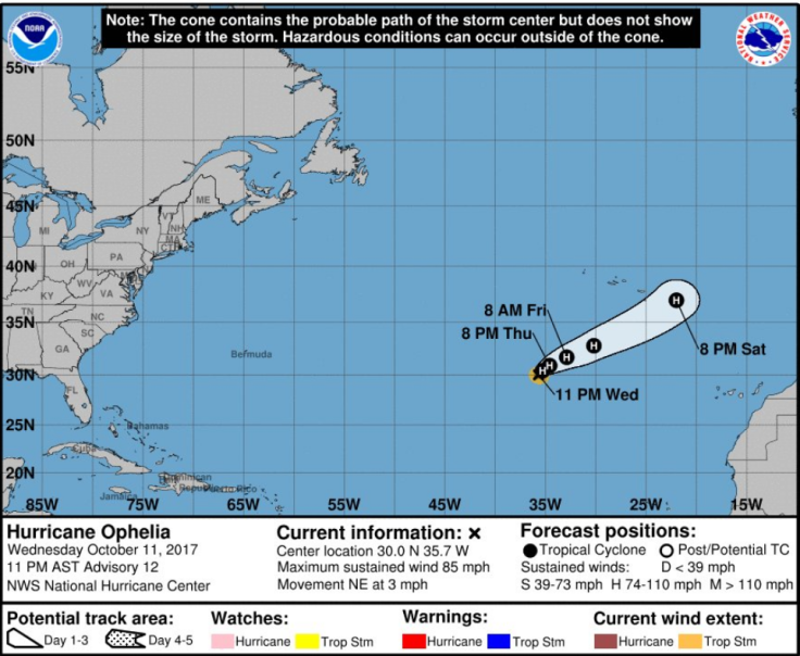
Hurricane Ophelia is strengthening over the eastern Atlantic Ocean and could soon hit Europe.
The hurricane is about 745 miles south-west of the Azores archipelago and could be strengthen over the next 24 hours.
"Ophelia is moving toward the northeast near 3mph (6km/h). This general motion is expected on Thursday, followed by faster motion toward the east-northeast or northeast on Friday," the US National Hurricane Centre (NHC) said on Wednesday 11 October.
Ophelia is also expected to hit the UK next week. However, the NHC said it would be downgraded to a storm by then.
Forecaster Eleanor Bell, of The Weather Channel, said: "Latest model guidance is indicating Ophelia will move in from the Azores across the Biscay area around Sunday and move on towards Britain early next week.
"This will push a plume of warmer air in from the south ahead of it. It is important to note we are still a week out and the models will likely vary in exact timing and position of Ophelia over the next few forecast runs.
"But we expect temperatures to be 4C to 6C above normal for the time of year over the weekend with a gradual cooler trend through next week.
"Above-normal temperatures could continue into Monday before getting cooler from Tuesday. However, temperatures are still set to be one or two degrees above normal."
Ophelia is the 10th consecutive Atlantic tropical storm to strengthen into a hurricane this year.
A series of hurricanes – Harvey, Irma, Maria and Nat – devastated several areas in the US and the Caribbeans, where hundreds were killed and injured and buildings were destroyed.
Interests in the eastern Azores should monitor the progress of #Hurricane #Ophelia for possible watches on Thursday https://t.co/tW4KeGdBFb pic.twitter.com/HalDW0Rv84
— NHC Atlantic Ops (@NHC_Atlantic) October 12, 2017
© Copyright IBTimes 2024. All rights reserved.
-

Zelensky Now On Russia's Most Wanted List: Joins a US Senator, Estonia's PM and Almost 100,000 More
-

US Christian Couple Start Anti-Woke School Designed Around 'Traditional American Values'
-

US Couple Donates $121M To Help Fund College Scholarships at a Ohio University, but There's a Catch
-

Fitness Instructor Sentenced To 11 Years In Prison For Demanding An End To Saudi Arabia's Guardian Laws


