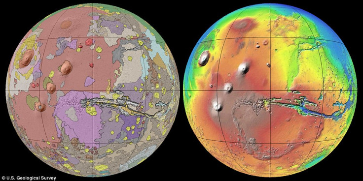
Map of Mars: US Geological Survey Creates Global Map of Red Planet Using Nasa Spacecraft

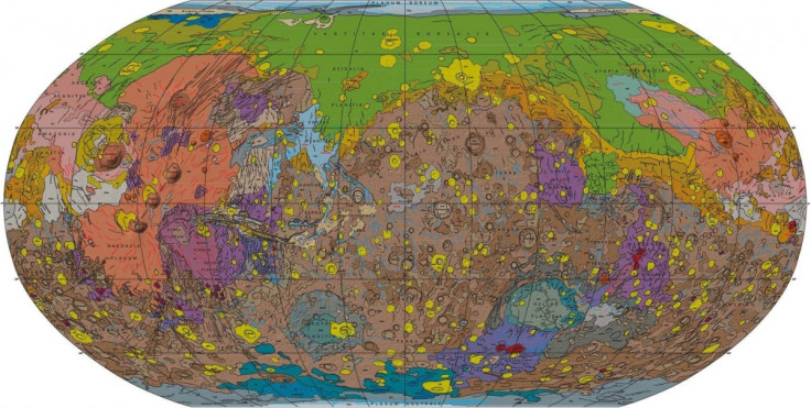
The United States Geological Survey has released the most detailed map of the surface of Mars to date, which astronomers believe will enhance knowledge about the Red Planet for future missions.
The map was created using observations from four orbiting spacecraft over a period of 16 years. Three Nasa spacecraft were used - the Mars Global Surveyor, Mars Odyssey and the Mars Reconnaisance Orbiter - as well as the European Space Agency's Mars Express Probe.
"Spacecraft exploration of Mars over the past couple decades has greatly improved our understanding of what geologic materials, events, and processes shaped its surface," lead author Kenneth Tanaka, of the USGS, told Space.com.
"The new geologic map brings this research together in a holistic context that helps to illuminate key relationships in space and time, providing information to generate and test new hypotheses."
Using a Thermal Emission Imaging System (THEMIS), Nasa's Mars Odyssey orbiter provided multiple temperature images taken at night - when researchers could observe how fast the surface of Mars heats up and cools down.
"We used more than 20,000 THEMIS nighttime temperature images to generate the highest resolution surface property map of Mars ever created," Robin Fergason, who helped create the map, told The Space Reporter. "Now these data are freely available to researchers and the public alike."
By analysing the thermal inertia of large regions, the scientists were able to determine the surface features on Mars. Thermal inertia is calculated by measuring the rate at which small-grain materials, such as dust, change temperature.
The map covers the entire surface of the planet, piecing together various data to reveal some new insights.
It reveals that the surface of the planet is older than previously thought. Three times as much surface area formed during the Early Noachian Epoch, the first major geological time period, than had been previously mapped.
Characteristics of the Early Noachian, ranges from about 4.1 to 3.7 billion years ago, include a widespread erosion, a high rate of meteorite impacts and the likely presence of water on the surface.
The new map also provides evidence that climate changes on Mars have previously allowed for surface water and near-surface groundwater and ice to form temporarily.
"Findings from the map will enable researchers to evaluate potential landing sites for future Mars missions that may contribute to further understanding of the planet's history," USGS acting director Suzette Kimball was quoted by NBC News.
"The new Mars global geologic map will provide geologic context for regional and local scientific investigations for many years to come."
You can download the new map for free here.
© Copyright IBTimes 2025. All rights reserved.
- MOST READ