

Space archaeologist Sarah Parcak appeals to public to help find ancient sites on satellite images

An innovative archaeologist is about to enlist a massive crew to help her hunt for ancient sites currently unknown to academics. Sarah Parcak, who considers herself a "space archaeologist," uses satellite imagery to track looted ancient burial sites and find pyramids beneath Egyptian cities. Now she hopes to turn millions of amateurs into space archaeologists.
Parcak plans to use broadly distributed satellite images and crowd sourcing to locate and, hopefully help protect, still-to-be discovered archaeological sites around the world. She'll use the digital platform GlobalXplorer, and will fund the project with $1m (£700,000) she collected as a 2016 TED prize winner.
"I wish for us to discover the millions of unknown archaeological sites across the globe," she says. "By building an online citizen science platform and training a 21st century army of global explorers, we'll find and protect the world's hidden heritage, which contains clues to humankind's collective resilience and creativity."
Parcak and her team will process satellite imagery in her operation to create what she calls a "super high tech version of Google Earth." Then her around-the-world amateur crew will pore over the images.
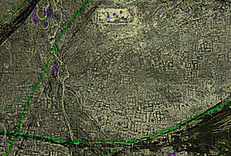
It won't be a tedious job searching every square inch of Earth for some sign of an undiscovered ancient ruin. Parcak hopes to help turn the hunt into a kind of game, she explained to National Public Radio.
Users will be given cards that show real, processed satellite imagery of a plot of land not more than 30 by 30 meters in size. There will be clues and keys by the side of the picture to help them identify whether they're seeing a known site or a new spot.
Part of the strategy is to create a kind of eye-training system to help searchers practice to spot useful indications in unexplored territory. Some hunters will be much better at the job than others. When thousands of people are scouring sites, the chances of success increase tremendously.
"The biggest problem we have when looking at satellite imagery is not the processing," she explained. "The hardest part is actually eye fatigue. Imagine hours and hours looking at satellite imagery. We miss things."
Crowdsourcing, she believes, will give researchers "lots of fresh pairs of eyes." Parcak hopes to launch the program by fall of 2016.
People will be able to pore over images on their computers at home, or check out sites on their phones during a lunch break at work.
"We're answering the big questions about who we are and where we've come from," she tells NPR. "The fact that we can get the world to be a part of that is pretty exciting."
© Copyright IBTimes 2025. All rights reserved.
- MOST READ


