

Ancient Lost World Hidden Beneath Ice Mapped for the First Time

An ancient lost world hidden beneath ice for millions of years has been mapped for the first time.
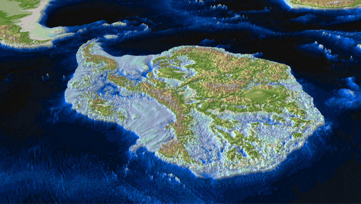
The latest edition of the Times Comprehensive Atlas of the World shows a previously unseen world of canyons, lakes, trenches and mountains beneath ice in Antarctica (the South Pole region of Earth).
Data from the British Antarctic Survey show the physical features, including mountains the size of the Alps and deep subglacial trenches.
Peter Fretwell, of the British Antarctic Survey, said: "This is the first time that the Times Atlas has included a map of sub-ice Antarctica. The map shows details of the rocky bed beneath the massive ice sheets which cover the surface of the continent. Data for this map comes from the recent Bedmap2 compilation, a large multi-national project that merged 50 years of geophysical data to make a seamless model of ice thickness and sub-ice topography."
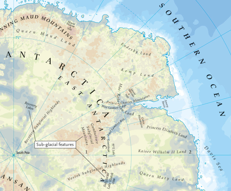
The Bentley Subglacial Trench is shown to reach a depth of 2,496m - one of the deepest points on the continent.
It also includes the location of the Lake Vostok and Recovery Lakes and the East and West Lambert Rifts, from which ice flows into the Amery Basin.
"It is very important to know how much ice there is and what the topography of the bed looks like, as this is one of the main controls on how quickly ice sheets melt with climate change," Fretwell said.
"The data in Bedmap2 (the Antarctic bedrock survey) is a key component of the Intergovernmental Panel on Climate Change ice-sheet models that try to predict future sea-level rise; as the world warms with ever increasing greenhouse gas emissions Antarctic ice will start to melt and cause global sea levels to rise, but the speed and amount of sea-level rise is very dependent upon the bed-topography under the ice sheet."
The map follows the discovery of a Grand Canyon-sized ravine in Antarctica. Researchers from the University of Bristol announced their discovery in August 2013.
David Vaughn, from the funding programme ice2sea, based at the British Antarctic Survey in Cambridge, said: "A discovery of this nature shows that the Earth has not yet given up all its secrets."
New Artic region data
The Times Comprehensive Atlas of the World also includes new features of the Arctic Ocean (in Earth's North Pole region), providing a picture of trends in Arctic sea ice cover. It reveals the change in average summer sea ice, with levels dropping to an all-time low in 2012. This information is seen as a climate indicator.
Walt Meier, a research scientist at Nasa's Goddard Space Flight Centre, said: "End of summer sea ice extent averages 40 per cent less than it used to be in the early 1980s. The ice is also substantially thinner, about half the thickness on average than during the 1980s. The loss of sea ice results in more energy being absorbed in the Arctic, contributing to amplified warming compared to the rest of the globe."
© Copyright IBTimes 2025. All rights reserved.
- MOST READ


