

Drones will go dinosaur hunting to help scientists track prehistoric footprints
Drone mapping of dinosaurs' tracks is expected to revolutionise the way researchers investigate dinosaurs.

Dinosaur research just got more high tech, thanks to drones which will now be used by researchers to track the footprints of the prehistoric creatures.
Drone mapping of dinosaurs' tracks is expected to revolutionise the way researchers investigate the ancient crutures as they allow scientists the ability to create digital maps, which in turn provide more in-depth data.
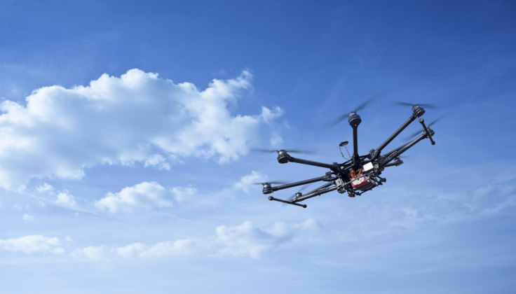
Australian researchers have begun using UAVs (Unmanned Aerial Vehicles) to track dinosaurs' footprints in remote locations. Anthony Romilio from the Vertebrate Palaeontology and Biomechanics Lab at the University of Queensland, and his team have created 3D models of tracks using laser scanner technology and high-resolution aerial photography.
According to the paper published at PeerJ by Romilo and his team, the digital approach in researching dinosaurs was adopted in response to the numerous environmental challenges faced when attempting to map dinosaur footprints along coastal lines.
Specifically Romilo and his team ventured to the northwest Australian coast to track dinosaur footprints, where the Indian Ocean's constant erosion of the rocks revealed hundreds of prehistoric footprints dating back to around 130 million years. The digital mapping also works as an effective conservation tool, especially considering how the ocean's constant threat of erosion looms over the site.
"Given the limited number of flat and dry surfaces, the DJI INSPIRE 1 UAV had operational advantages over traditional ichnological mapping techniques," reads the paper. "As a quadcopter, it is able to perform vertical takeoff and landings within a relatively small area... a capability that proved invaluable at Minyirr with its limited number of flat and dry surfaces."
Digital mapping also offers enhanced and in-depth data about the areas being investigated for footprints. "You may think it's the track of a dinosaur, but after you do some 3D modelling, you'll be able to confirm what kind of dinosaur it was, if it was moving in a particular manner, or whether or not it's a dinosaur track at all," Romilio told Mashable.
"We can get a good idea of the size of the animals, if they travelled in herds, their speed," he said. "We can build up a more detailed picture of their actual behaviour."
Romilo and his team have gathered data from over 70 such sites and plan to further analyse the information, to ascertain what other details they may reveal about the ancient creatures.
© Copyright IBTimes 2024. All rights reserved.
-

Doug McMillon Unloaded Walmart Trucks For $6.50/Hour In 1984, Now He's The CEO
-
Utah Couple Doesn't Know Cat Jumped Into Amazon Package, Accidentally Ships It to California
-
How Are Female Tech Firms Fighting the Employment Crisis in the West Bank?
-

Italian PM Has British Newborn With Heart Defects Airlifted to Rome for Treatment Unavailable in UK


