

Nasa has invented a stopwatch that can measure a billionth of a second from space
Engineers have worked out how to precisely measure the distance between Earth and a satellite in orbit.

Nasa has invented a stop watch that can measure a billionth of a second in order to help its scientists be able to measure height in space so it can build a more accurate and detailed 3D model of the Earth.
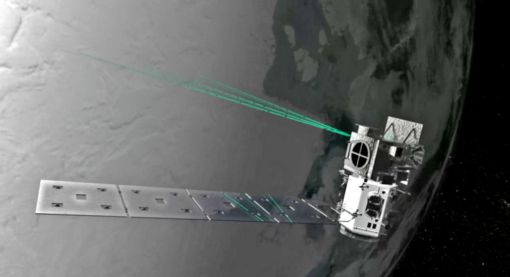
Engineers at the Nasa Goddard Space Flight Center in Maryland have built an incredibly precise timer for the Ice, Cloud and land Elevation Satellite-2 (ICESat-2), which is scheduled to be launched into orbit in 2018.
The stopwatch on the satellite will make use of six green 10kHz laser beams to measure crucial heights on Earth to within 2 inches, such as the rate at which ice sheets and polar caps are melting to track climate change.
Measuring distances using light is a great solution in space, but measuring light is incredibly difficult because of the speed at which it moves. To give you a point of reference, it takes just 8mins 20secs for light from the sun to cross a distance of 150m km to reach the Earth, so being able to measure the exact time the light takes is key.
Using speed of light to calculate distance
To solve this problem, the new timer features a series of clocks invented by Nasa that work together with its Advanced Topographic Laser Altimeter System (ATLAS) laser instrument. The idea is that when the satellite emits a pulse of light from the laser, a few photons are sent to a start pulse detector in the instrument which triggers the timer.
The rest of the billions of photons in that one single laser pulse are meanwhile streaming down to Earth, and the stopwatch times how long it will take for the laser pulse to get to a specific location on Earth, bounce off the planet's surface and return back up to the satellite.
So for example, Mount Everest is the highest mountain in the world. Its peak has a higher altitude than anything else, so if the satellite were to send out a laser pulse down to it, the photons would return to the satellite sooner than they would from a low-lying city, which would have a greater distance from the satellite than the mountain.
"Calculating the elevation of the ice is all about time of flight," said Phil Luers, deputy instrument system engineer with the ATLAS instrument. "If you know where the spacecraft is, and you know the time of flight so you know the distance to the ground, now you have the elevation of the ice."
Measuring light down to the picosecond
The stopwatch system on the satellite also includes a telescope receiver to catch the returning photons and filter out any light that didn't come from the laser, especially sunlight. It does this by only accepting photons that match the exact shade of green of the ATLAS lasers, and firing the laser 10,000 times a second will help the scientists build a concise picture of heights and distances.
To make things even more precise, the satellite features the standard GPS receiver clock that ticks off every second, and there's also another clock in the ATLAS system that counts off every 10 nanoseconds. Then as the photons return to the satellite, a third clock measures the return time in hundreds of picoseconds.
Of course, there will still be other challenges to ensure that the time measurements are as precise as possible, so Nasa's scientists are also coding software programs that combine the results of all the many photon journeys to give the best travel time result. The software also has to compensate for how long the laser pulses take to move through the fibres and wires of the ATLAS instrument, as well as how temperature change impacts the electronics.
"Light moves really, really fast, and if you're going to use it to measure something to a couple of centimetres, you'd better have a really, really good clock," said Tom Neumann, ICESat-2's deputy project scientist. "We correct for all of those things to get to the best time of flight we possibly can calculate."
© Copyright IBTimes 2025. All rights reserved.
- MOST READ


