

Nasa to set up laser-ranging station at Norway's Svalbard to track satellites, ice sheets
This will be a part of Nasa's global network of space geodetic stations that measure the size and shape of the Earth.
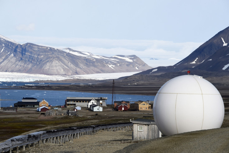
Nasa will be setting up a laser-ranging station to track satellites and changes in the ice sheets in collaboration with the Norwegian Mapping Authority.
This observatory will be a part of Nasa's global network of space geodetic stations that measure the size and shape of the Earth, the planet's orientation in space, as well as study exact locations of spots around the globe and how they change through time according to Nasa.
Nasa says this station will play an important role in the navigation and positioning of satellites in orbit.
An agreement was signed on the 7 August between Norway and Nasa which deals with the building of the facility within the scientific base of Ny-Ålesund, Svalbard. Nasa will also provide "expert consultation" on how their instruments have to be operated.
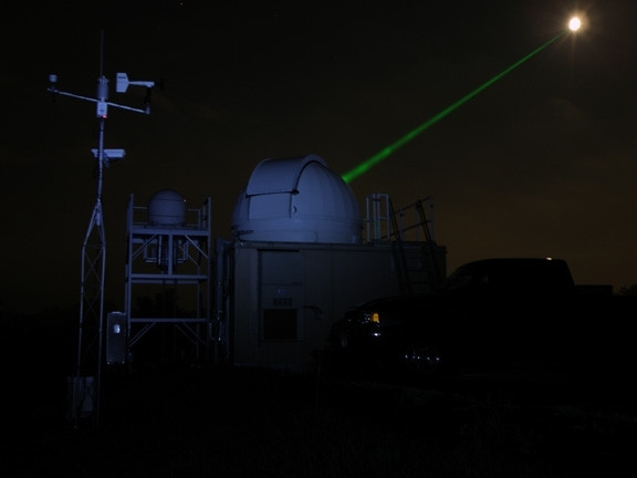
This facility will track orbiting satellites by firing ultra-short pulses of laser beams at them, specifically, ones that have retroreflectors- mirrors that are placed on satellites specifically to bounce lasers back to Earth. The station will then calculate time delay from the returning beam of light to measure and position said satellite in space.
Measurements taken this way are accurate to around 1mm, according to a publication by Nasa.
By combining measurements from other geodetic instruments around the world, Nasa will reportedly help make the Global Geodetic Reference Frame (GGRF) more precise. GGRF is the measure upon which coordinates for all locations on Earth's surface are calculated.
This reference frame is also a requirement when looking to measure changes in sea level, movement on the crust as well as in everyday tech like GPS.
"From the NASA perspective, laser ranging is important to understanding where our spacecraft are, as well as where on Earth their measurements are located," said Stephen Merkowitz, space geodesy project manager at Nasa's Goddard Space Flight Center in Greenbelt, Maryland. "Laser ranging is needed for satellites that require very precise positioning measurements" he added. As of now, he said that they are tracking over 90 satellites that are not only operated by Nasa, but by various agencies from all over the world.
The Svalbard station will be the northernmost such geodetic station and will be useful for satellites that have polar orbits.
Challenges of working and setting up an observatory near the North Pole are numerous according to the report. Nasa will have to build domes that are strong enough to break open ice sheets that are likely to form during frigid northern winters. Conversely, summers have constant daylight that last several weeks and Nasa said that they need to build telescopes and related instruments that can stay stable for months at a time.
Construction of the scientific base in Svalbard was started in 2014 and Norway's mapping authority hopes to have all systems up and running by 2022. Svalbard, the most northerly town in the world is also home to the Doomsday seed vault which got flooded this year owing to rising global temperatures.
© Copyright IBTimes 2025. All rights reserved.
- MOST READ


