Here's Cuba as you've never seen it before. Lithuanian aerial photographer and publisher Marius Jovaiša is the first artist to receive government permission to fly over the country and photograph it from above.
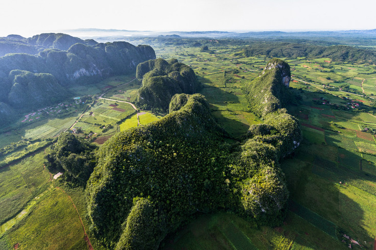
Towering mogotes, cone-shaped limestone mountains covered in vegetation, are the signature geological feature in Valle de Viñales.Unseen Cuba / Marius Jovaisa
"Nobody had been able to take aerial pictures of the country because of the secretive political regime and technical difficulties," he told IBTimes UK. "I thought it would be awesome to try to become the first man on the planet who could convince the Cuban government to give permission for such an endeavour."
"That was the beginning of a long story," he continued. "I spent two years in the paperwork and bureaucracy stage. There were so many crazy requirements, unpleasant surprises, changes of circumstances, rules etc that I could write a separate book about it. I guess the Cuban military live by the rules written in the 1960s. Even though now you can go to Google Earth and see every square metre of Cuba, the military still tightly controls the airspace and its secrets."
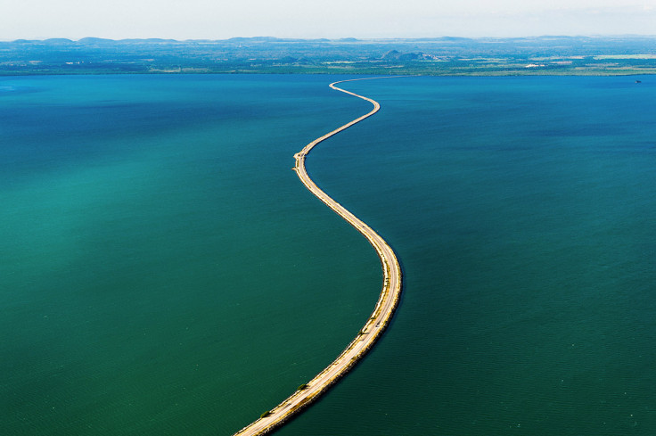
The 30-mile El Pedraplén causeway cuts through Buena Vista Bay, linking mainland Cuba to the Cayería del Norte cays in Villa Clara Province.Unseen Cuba / Marius Jovaisa
Jovaiša says on most aerial photography projects he would simply rent a helicopter, but the rental service in Havana had only a huge Russian-made MI-8 helicopter that wasn't viable. He bought a custom-built ultralight trike and had it shipped over from Australia.
He says the Unseen Cuba project took five years and a million dollars to come to fruition. But the results are spectacular. Turquoise seas, white sands, ancient villages, dramatic mountains and cities frozen in time.
In this gallery, we publish a selection of his beautiful photographs. See the Unseen Cuba website to learn more about the project and buy a copy of the book, featuring 400 aerial photos of the Caribbean island. There is also an app for Android and Apple phones and tablets, with additional interactive content.
Western Cuba
The majestic Havana, the shores of Varadero, the beauty of Ciénaga de Zapata, the timeless landscapes of Viñales ... the western third of the island of Cuba, comprised of the provinces of Pinar del Río, Artemisa, Havana, Mayabeque, Matanzas and Isla de la Juventud, is as diverse as it is enchanting.
Havana – or San Cristóbal de La Habana – is a grand metropolis of 2.2 million inhabitants and the beating heart of Cuba. Flanked by El Morro Castle and
the historic city centre of Old Havana, a narrow channel gives way to Havana Harbour, the island's main port.
Morro Castle (foreground) and Fortaleza de San Carlos de la Cabaña dominate the promontory that overlooks downtown Havana.Unseen Cuba / Marius JovaisaCastillo del Príncipe, built in 1779 on Loma de Aróstegui, was one of the many military fortifications the Spaniards erected to protect Havana from enemy attacks.Unseen Cuba / Marius JovaisaCompleted in 1929 and the seat of the Cuban government until 1959, El Capitolio was Havana's tallest building until the 1950s.Unseen Cuba / Marius JovaisaIn its 80 years of existence, Hotel Nacional de Cuba has hosted scores of illustrious guests ranging from Winston Churchill to Frank Sinatra.Unseen Cuba / Marius JovaisaLocated in the Vedado neighbourhood of Havana, Cementerio de Cristóbal Colón is considered one of the greatest cemeteries in Latin America.Unseen Cuba / Marius JovaisaLocated at the mouth of Almendares River, Torreón de la Chorrera was built in 1646 and today houses a restaurant.Unseen Cuba / Marius JovaisaAffectionately known as the Athens of Cuba, the provincial capital city of Matanzas is the birthplace of popular Cuban rhythms such as danzón and rumba.Unseen Cuba / Marius JovaisaThe laid-back, rural nature of Valle de Viñales as well as its lush, dramatic geography has turned this slice of Pinar del Río into a major tourist destination.Unseen Cuba / Marius JovaisaThe striking beauty of Valle de Viñales prompted Unesco to designate the area a World Heritage Site in 1999.Unseen Cuba / Marius Jovaisa
Central Cuba
Tourism is a key industry in the heart of the island, fuelled by the presence of two archipelagos of cays lined with white-sand beaches and bathed by turquoise waters, as well as charming colonial towns steeped in history like Trinidad and Remedios.
Settled by the foothills of Sierra Escambray, the colonial city of Trinidad has been a Unesco World Heritage Site since 1988.Unseen Cuba / Marius JovaisaPicturesque Valle de los Ingenios was one of Cuba's most prominent centres of sugar production during the 18th and 19th centuries. The area was declared a Unesco World Heritage Site in 1988.Unseen Cuba / Marius JovaisaThe charming colonial town of Remedios, in the province of Villa Clara, was founded in the 16th century. The town is famous for its Parrandas de Remedios, an annual Christmas celebration featuring floats, fireworks and dance competitions.Unseen Cuba / Marius JovaisaThe sun sets on the portion of scenic El Pedraplén causeway that leads to the resort area of Cayo Las Brujas.Unseen Cuba / Marius JovaisaPlaya Ensenachos is the largest beach on Cayo Ensenachos, the smallest of the three main cays on Cayerías del Norte.Unseen Cuba / Marius JovaisaPlaya Perla Blanca in Cayo Santa María boasts powdery white sands and rocky coves.Unseen Cuba / Marius JovaisaLike brushstrokes on a sandy canvas, clusters of mangroves and thin streams of water add a splash of colour to the coastline of northern .Unseen Cuba / Marius JovaisaWhite-sand beaches and azure waters beckon at Jardines del Rey, but their most treasured attractions may be what lies beneath the surface: teeming coral reefs that lure snorkellers and divers from around the world.Unseen Cuba / Marius Jovaisa
Eastern Cuba
Columbus first set eyes on these shores when he discovered Cuba and called it "the most beautiful land human eyes had ever seen". From the pristine white (and black) sand beaches in Holguín Province to the highest mountain in Cuba, this is a land of dramatic geographic contrasts. Small wonder, then, that it's home to four national parks, two Unesco biosphere reserves and two Unesco Natural World Heritage Sites.
It's also the cradle of revolution and strife. Fidel Castro launched his revolution in the eastern capital of Santiago de Cuba.
On the western edge of Santiago de Cuba Province, Pico Turquino rises higher than any other mountain in Cuba, reaching almost 6,500ft above the Caribbean Sea. Part of the Sierra Maestra Mountain Range and the main attraction of Parque Nacional Turquino, this is a haven for hikers and mountain climbers. Pico Turquino and the Sierra Maestra mountains have played an important role in the nation's history. It was here that Fidel Castro's army camped and launched its forays against Batista's troops. At the summit of Pico Turquino, a bust of José Martí pays homage to the hero of the second War of Independence.Unseen Cuba / Marius JovaisaThe rich earth and rolling fields of Granma Province have been given over to agriculture, with coffee serving as its principal export. These peaceful, pastoral landscapes belie the region's connection to the revolutionary history of the country.Unseen Cuba / Marius JovaisaRío Cauto is the longest river in Cuba, and its mouth opens into this stunning network of lagoons in the Gulf of Guacanayabo.Unseen Cuba / Marius JovaisaThe misty mountains of the Sierra Cristal range are home to verdant pine forests, nickel mines and more than 100 species of endemic flora.Unseen Cuba / Marius JovaisaEl Yunque (which means "The Anvil" in the native Taíno tongue) gets its name from its signature flat peak. The distinctive plateau provides a dramatic backdrop to the city of Baracoa in Guantánamo Province. It's a popular trekking destination, thanks in part to the incredible panoramic views it offers from its summit.Unseen Cuba / Marius JovaisaFounded in 1511 by Diego Velázquez de Cuéllar, Baracoa is Cuba's oldest city and one of its more unique settlements. Cut off from the rest of the island for centuries, Baracoa has developed a singular culture, identity and cuisine. The ancient and tranquil city straddles the Bay of Baracoa, with the colonial city center to the east and the airport to the west.Unseen Cuba / Marius JovaisaOf course, it wouldn't be a Cuban city without a baseball field. Located in the south of the city, Baracoa's Estadio Manuel Fuentes Borges has the distinct advantage of being located right on the beach. There may not be any spectators at today's game, but one of these children just might be the next superstar ballplayer to come from Cuba.Unseen Cuba / Marius Jovaisa