NASA, SpaceX Launch Pickup Truck-Sized Satellite — Here's How Sentinel-6B Can Help With Flood Predictions
The new satellite would also help astronauts have safer return missions
NASA confirmed a smooth launch for Sentinel-6B from California on 16 November 2025. SpaceX carried the pickup-truck-sized NASA satellite into orbit during a clear night over Vandenberg Space Force Base.
Engineers began tracking early signals soon after separation from Falcon 9. Mission teams expect stronger sea level forecasts once readings reach ground systems.
This new satellite continues the crucial work started by Sentinel-6 Michael Freilich in 2020. NASA aims for uninterrupted data streams for rising water studies around coastal regions.
Such information supports flood models used by several public agencies worldwide.
READ MORE: 3I/ATLAS: ESA Mars Probe Reveals Closest-Ever Images of 'Alien' Object
READ MORE: Tucker Carlson Says US Government 'Made a Deal' With 'Demons' for Nuclear Technology
SpaceX Successfully Launches NASA's Sentinel-6B
According to NASA, SpaceX's Falcon 9 lifted Sentinel-6B at 9:21 p.m. PST from Launch Complex 4 East. Spectators across Santa Barbara and Ventura counties heard sonic booms after booster return.
That booster completed its third flight after earlier Starlink missions. A controlled landing followed at Landing Zone 4 without delay.
Ground stations in northern Canada made first contact at 10:54 p.m. PST. NASA said all systems functioned normally during that early pass. Teams reported stable performance across major subsystems.
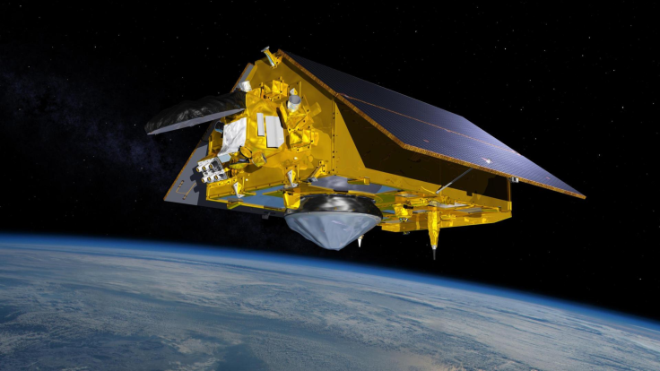
What Sentinel-6B Brings Into Orbit
Sentinel-6B measures nearly six metres in length with a mass near 1,192 kilograms. Two fixed arrays and two deployable panels provide extensive power coverage across each orbit. Engineers designed strong structures for long-duration atmospheric readings.
Six science instruments support sea level and ocean studies. NASA contributed a microwave radiometer and a radio occultation package for precise water and air readings. A laser retroreflector supports detailed tracking from global stations.
This spacecraft flies in a repeating orbit that revisits many areas at varying local times. That pattern helps teams compare long-term changes across several ocean basins.
Global Partnership Behind Sentinel-6B
NASA works with ESA, EUMETSAT, NOAA, CNES and European Commission staff throughout each mission phase. These groups maintain regular contact on calibration, modelling and data release schedules.
'Collaboration between partners remains vital for sustained results across such major missions', said ESA official Simonetta Cheli.
Nicky Fox from NASA stated that 'Sentinel-6B will build upon earlier achievements through improved sea level readings used by communities and operations across many regions'.
Sentinel-6B Could Help Flood and Weather Predictions
Sentinel-6B measures sea levels with high precision for improved flood planning. Emergency groups rely on such readings during storm seasons in vulnerable zones. Readings also improve forecasts for wind speeds, wave heights and humidity patterns.
Dave Gallagher from NASA JPL said 'This satellite's instrument suite will measure around ninety percent of Earth's oceans down to fractions of an inch'.
Karen St Germain added that observations will guide choices for shipping, fishing, and coastal response teams.
Warm regions often signal rising storm intensity, so updated data benefits hazard alerts. Analysts expect sharper hurricane assessments once models absorb repeated passes.
Safer Return Missions For Astronaut Crews
Sentinel-6B supports landing predictions for returning spacecraft. Accurate water levels and atmospheric readings guide trajectory checks for crew vehicles. NASA expects future Artemis missions to benefit from such measurements.
Nicky Fox noted that satellite readings will support safer astronaut returns during those operations.
Mission Duration and Long-Term Goals
Sentinel-6B should operate for roughly five and a half years. It will start behind Sentinel-6 Michael Freilich for early calibration work. That phase ensures consistent global sea level records dating back three decades.
Once cross-checks finish, Sentinel-6B becomes the reference craft for sea level studies. It travels 1,336 kilometres above Earth while completing 13 loops daily.
Data from those loops will support climate models and marine forecasts worldwide.
© Copyright IBTimes 2025. All rights reserved.
- MOST POPULAR IN Science