Four Twisters Confirmed as Severe Storm System Charges Toward US East Coast
Based on the article, provide me a closing statement with a call to action, a meta description and a shorter meta description.

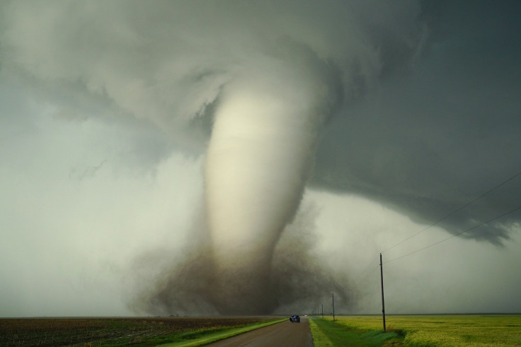
Spring arrived in January with a vengeance. While most Americans anticipated another bleak winter weekend, the central United States woke to something far more sinister: a sprawling storm system so powerful it spawned four confirmed tornadoes before breakfast, leaving a trail of destruction from Oklahoma to Kansas and setting meteorologists on edge as it barrels eastward toward millions more.
This isn't the kind of weather system residents typically fear in early January—it's the kind that forces the National Weather Service to deploy damage assessment teams to catalogue destruction that belongs to May, not the new year.
The unusually warm air mass fuelling this outbreak—with temperatures soaring into the lower to middle 60s across central Oklahoma—created a collision of atmospheric forces so powerful that severe weather erupted across the Southern Plains on Thursday morning.
By day's end, the National Weather Service office in Norman had confirmed four tornadoes, three rated as EF1 and one as EF0, with damage assessments continuing as teams uncovered additional areas of destruction.
Four tornadoes have been documented so far from this morning's storms across central Oklahoma. EF1 tornadoes struck Purcell, Shawnee and near Shawnee Twin Lakes, and an EF0 tornado occurred near Lake Thunderbird. Investigation continues in these and other areas of damage. #okwx pic.twitter.com/6ERXnZWCpl
— NWS Norman (@NWSNorman) January 9, 2026
Yet even more troubling than the confirmed twisters was the raw power on display: the highest wind gust on record for Thursday reached a staggering 88 miles per hour at Wynona, Oklahoma, tearing roofs from homes and reducing shop buildings to wreckage.
An 81 miles per hour wind gust was recorded near Independence, Kansas, where power lines snapped like matchsticks, poles toppled, and several outbuildings were obliterated. One semi-truck was actually blown over on Interstate 35 near Purcell, and multiple structures sustained significant damage from the tornado that swept through the area.
Most remarkably—given the violence unleashed—Thursday's tornado activity resulted in no reported injuries, a stroke of good fortune that may not extend to the millions now in the path of this relentless system.
Tornado Warning Escalates: Four Confirmed Twisters Mark Ominous Start to 2026 Severe Season
What's particularly alarming to meteorologists is not just the fact that Oklahoma experienced four January tornadoes, but when it happened. Oklahoma became the first state in the entire country to record a tornado in 2026.
For context, the state's average in January is considerably lower, making Thursday's outbreak almost unprecedented—though not quite. Oklahoma previously recorded five January tornadoes on a single day in 2023, meaning Thursday's event is already approaching that state record.
Gary McManus, Oklahoma's state climatologist, expressed concern about this early and aggressive severe weather activity. 'It's something we certainly don't like to see this early because you worry about, you know, "what's the rest of the year going to be like?"' he remarked, voicing the professional concern many in the meteorological community now share.
The fact that winter tornadoes are happening with increasing frequency is deeply troubling to those who track long-term weather patterns. Whilst January tornadoes aren't entirely unheard of in Oklahoma—the state has experienced 30 since 1950—the recent acceleration is concerning.
Over the last four or five years alone, Oklahoma has had roughly a dozen January tornadoes, suggesting a concerning shift in seasonal weather patterns. As one meteorologist noted, these early-season outbreaks carry troubling implications for what might unfold across the traditional spring severe weather season.
Severe Weather Threat Sweeps East: Wind, Rain, And Isolated Tornadoes Target Weekend
As Thursday's devastation was still being assessed, the same storm system that spawned four tornadoes across Oklahoma began its eastward advance, carrying with it the potential for continued mayhem across the East Coast.
What unfolded over the following days was a meteorological challenge of extraordinary complexity—the kind that forces forecasters to issue warnings for multiple, overlapping hazards simultaneously.
By Friday, the frontal system capable of producing severe storms and flash flooding continued its relentless march across the Gulf Coast and Southeast. Overnight into Saturday morning, isolated strong to severe thunderstorms—complete with strong wind gusts and isolated tornadoes—threatened parts of the Carolinas and extended as far east as the mid-Atlantic.
The threat of tornadoes on Saturday afternoon remained low but real, particularly across northern Georgia and South Carolina, with AccuWeather citing Atlanta and Greenville, South Carolina, as being in the 'some risk' zone.
The scale of potential impacts stretched across an almost incomprehensible geographic area. Locally heavy rain was forecasted for the Deep South, particularly southern Mississippi and western Alabama, where accumulations could exceed five inches by early Saturday—creating conditions ripe for flash flooding.
The Weather Prediction Center upgraded its flash flooding risk from a slight risk to a moderate risk, a move that reflected growing concern about the rainfall totals and their consequences.
Across the Midwest, Northern Tier, and increasingly the East, strong winds with gusts occasionally exceeding 40 miles per hour were expected throughout Saturday and Sunday. These winds, when combined with any areas of snowfall, would create treacherous driving conditions with visibility reduced to dangerous levels and roads becoming increasingly unpredictable.
Most confounding for weather forecasters was the utterly anomalous nature of this January storm. Snow was expected in parts of the western Great Lakes and upper Midwest, yet the lack of cold air in place meant this would not be a major snowmaker east of the Rockies.
Light to moderate snowfall would blanket parts of the Great Lakes and northern New England, but the unseasonably warm air mass would prevent the kind of accumulations typical for mid-winter storms.
By Sunday, wind remained the only significant remaining concern in the Midwest and East, with some showers lingering in eastern New England and wrap-around snow persisting from the Great Lakes to the Appalachians.
Most areas were expected to dry out by Monday, though the damage assessment would continue for weeks—another reminder of how dramatically weather patterns have shifted in recent years, transforming January from a quiet month into a season of atmospheric unpredictability.
© Copyright IBTimes 2025. All rights reserved.
- MOST POPULAR IN World