Apple iOS Maps Directs Drivers Onto Airport Taxiway

Apple has issued a temporary fix to a flaw in its iOS Maps application which directed drivers onto the aircraft taxiway of an Alaskan airport.
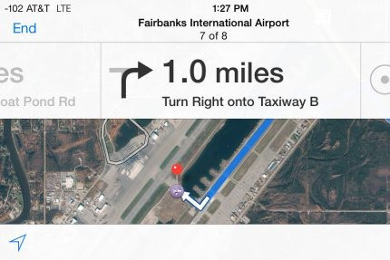
Drivers relying on the iPhone application to get to Fairbanks International Airport found themselves turning onto Taxiway Bravo, which leads across the airport's main runway and directly to the terminal, where Boeing 737s and other commercial airliners fly from.
At least twice in September, drivers from out of town who followed the app's directions found themselves approaching the live runway and a ramp connecting the taxiway to the passenger terminal, reports Alaska Dispatch.
"These folks drove past several signs. They even drove past a gate. None of that cued them that they did something inappropriate," said Melissa Osborn, chief of operations at the airport.
As a temporary fix, the application now returns the message "a route could not be determined" when users ask for directions to Fairbanks Airport.
As of 26 September, IBTimes UK was unable to get driving direction to the airport from property nearby, suggesting the temporary solution was working.
Vague directions
This was not a case of vague directions leaving unfamiliar drivers with no choice but to hunt around the airport for the correct road, the app's turn-by-turn directions specifically instructed drivers to access the taxiway, followed by instructions to drive towards the runway in an attempt to reach the terminal on the opposite side of the airstrip.
The app did not tell drivers to turn onto the runway itself, but from the finish point of Taxiway Bravo - named by the directions as 'Taxiway B' - unfamiliar drivers would see the terminal building at the other side of the airport and proceed towards the runway in an attempt to reach it.
Angie Spear, marketing director for the airport, told Alaska Dispatch that on 6 September a lost driver in a rental car was stopped by airport personnel, police and the TSA as they attempted to cross the runway.
Airport staff complained through the attorney general's office to Apple, Spear said.
On 20 September a second attempted runway crossing prompted the airport to close the aircraft access route to Taxiway Bravo for the connecting Float Pond Road.
First warning
Spear told the BBC: "[the lost drivers] had to enter the airport property via a motion-activated gate, and afterwards there are many signs, lights and painted markings, first warning that aircraft may share the road and then that drivers should not be there at all.
"They needed to drive over a mile with all this before reaching the runway. But the drivers disregarded all that because they were following the directions given on their iPhones."
The problem was blamed on the app using the central point of the airfield as the final destination point if users asked for directions to the airport's name; if they used the terminal's own street address the issue did not occur.
Released with iOS 6 for iPhone and iPad a year ago, Apple's own Maps application was developed to replace Google's system, which had been used by the iPhone since 2007. But when launched, Apple's alternative was widely criticised, with whole towns in the wrong location, poor 3D imagery and large areas of the UK covered by poor quality and even black-and-white satellite images.
© Copyright IBTimes 2025. All rights reserved.
- MOST POPULAR IN Technology