Britain Braces for Storm Floris: 60mph Gales and Flash Flood Warnings as Torrential Downpours Set to Batter the UK
With 60–85mph winds and heavy rain on the way, Storm Floris threatens widespread disruption, flash flooding, and hazardous travel across parts of the UK

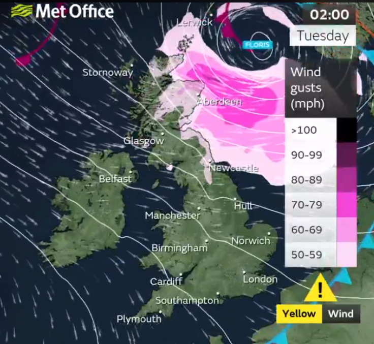
The UK is bracing for a powerful summer storm, as the Met Office issues a yellow weather warning for wind from 6am on Monday, 4 August until 6am on Tuesday, 5 August, covering Scotland, Northern Ireland, northern England and north Wales. The alert, prompted by Storm Floris, warns of unseasonably strong winds and heavy rainfall set to batter large swathes of the country.
Gale-Force Winds to Lash Coastal and Highland Areas
Inland areas within the warning zone are expected to face westerly gusts of 40–50mph, while winds along exposed coasts and higher ground could surge to 60–70mph. In northern Scotland, particularly coastal and hilly regions, gusts may reach up to 85mph, forecasters said.
Met Office Chief Meteorologist Matthew Lehnert warned: 'Across the warning area, many inland areas are likely to see gusts of 40–50mph, with 60–70mph more likely at higher elevations and around exposed coasts in Scotland. There is a small chance that some locations here could even record gusts of 85mph.'
Torrential Rain Triggers Flash Flood Risk
The winds will be accompanied by intense rainfall, with downpours likely to overwhelm low-lying and urban areas, especially across London, the Midlands, and eastern and southern England. The rapidly deepening low-pressure system may produce sudden deluges, raising fears of flash flooding and localised damage.
Infrastructure, Travel and Power Networks Under Threat
The Met Office warns that the storm could severely disrupt travel and infrastructure. Potential hazards include:
- Flying debris posing a risk of injury or fatality
- Damage to buildings, such as tiles being blown from roofs and sea defences being overtopped
- Power outages and disruption to mobile networks
- Cancellations or delays on road, rail, ferry and air services, along with possible closures of coastal roads and bridges
Drivers Urged to Slow Down and Secure Loads
Rod Dennis of the RAC issued a warning to motorists, particularly those heading on summer holidays:
'This unseasonable bout of stormy weather will mean drivers in the north and west of the UK need to take extra care at the start of next week.'
He advised anyone towing trailers or caravans, or driving with roof boxes and tent racks, to double-check that their equipment is properly fastened. Motorists should also reduce speed, avoid exposed routes, and delay travel if conditions worsen.
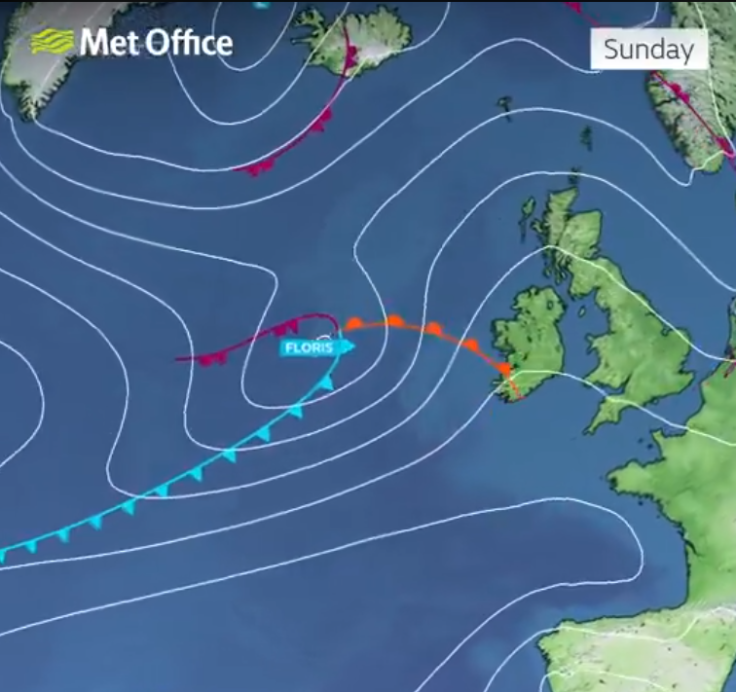
Weekend Lull Sets Up 'Calm Before the Storm'
The weekend preceding the storm is forecast to be deceptively calm. Saturday will bring sunshine and light winds, while Sunday sees a shift to increasing breezes and patchy showers, mostly in western regions. Experts warn that this reprieve could lull travellers into a false sense of security.
There's a lot of talk about #StormFloris on Monday
— Met Office (@metoffice) August 1, 2025
But before then, much of the UK will have a fine and pleasant Saturday
With sunny spells for many, it's important to remember that UV levels are still widely high at this time of year ☀️ pic.twitter.com/bo9Hy1ihnY
Why Summer Storms Can Be More Dangerous
Though named storms are usually associated with autumn and winter, summer systems like Floris can wreak greater havoc. With trees in full leaf, holidaymakers on the move, and garden furniture and tents in widespread use, damage potential is significantly heightened.
Scottish Highlands and Coastal Areas Most at Risk
Regions like Moray, Aberdeenshire and the Scottish Highlands are likely to take the brunt of Floris, where gusts could peak near 85mph. Coastal residents should brace for high waves and debris washed onto roads, homes and promenades.
Travellers, campers, and eventgoers are advised to monitor travel updates and local weather forecasts closely, especially in areas vulnerable to flooding or road closures.
Key Safety Measures for the Public
The Met Office recommends several precautionary actions:
- Secure loose outdoor items such as bins, trampolines and tents
- Avoid walking or driving in exposed coastal and upland areas
- Monitor updates via the Met Office and local authorities
- Prepare for power outages with torches, power banks and spare batteries
- Delay or reconsider travel through affected regions where possible
Stay Alert as Storm Floris Nears
Storm Floris is a stark reminder that summer doesn't guarantee serenity in the UK. With forecasts of wind speeds up to 85mph and flash flooding a real possibility, the public is urged to take warnings seriously.
Keep an eye on the sky and both feet on solid ground as this powerful system moves in—and stay tuned to official Met Office alerts.
© Copyright IBTimes 2025. All rights reserved.
- MOST POPULAR IN Science