Flash Flood Warning: NY and New Jersey Brace for Torrential Rainfall — Up to 5 Inches Per Hour Possible
Road closures, train suspensions and over 1,100 flight cancellations affect commuters and travellers
A powerful cold front has unleashed severe thunderstorms along the US Atlantic coast, with New York and New Jersey preparing for potentially record-breaking flash flooding. Forecasters warn that rainfall could reach up to 3 inches (7.6cm) per hour in many areas, with isolated spots seeing as much as 5 inches (12.7cm) in a matter of hours.
States of emergency have been declared in both states, with authorities urging residents to avoid unnecessary travel amid warnings of life-threatening conditions during the evening commute.
Emergency Declarations Across the Tri‑State
On 31 July 2025, New York City Mayor Eric Adams and New Jersey's Acting Governor Tahesha Way declared states of emergency following widespread flash flood warnings issued by the National Weather Service. The alerts cover large parts of the north-east United States, including the I-95 corridor, Reuters reported.
Forecasts indicate up to 5 inches of rainfall in parts of New York City and between 1 to 3 inches across New Jersey, with locally heavier bursts reaching 5 to 7 inches. Officials have warned of potential landslides, flash flooding and dangerous travel conditions.
In response, emergency services mobilised sandbag distribution, opened shelters and advised residents to stay indoors unless absolutely necessary.
Flash Flooding and Travel Disruption
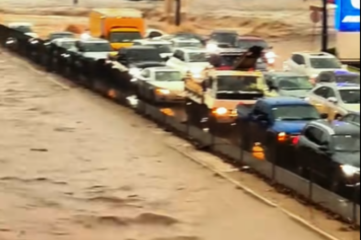
Rainfall rates of 3 inches per hour are expected to overwhelm drainage systems across the region. Short bursts of 4 to 6 inches may trigger flash flooding within minutes, The Guardian reported. The storm's timing, coinciding with peak commuter hours, has raised major concerns for road, rail and pedestrian safety.
In Queens, emergency crews rescued drivers stranded in submerged vehicles on the Clearview Expressway. Elsewhere, several key roads and underpasses were closed. Amtrak suspended services between Philadelphia and Wilmington due to flooding on the tracks, AP News and ABC7 News reported.
Airports, Trains and Utilities Severely Affected
Major airports, including JFK, LaGuardia, Newark and Philadelphia International, have reported more than 1,100 flight cancellations. New Jersey Transit and parts of the New York City Subway have been suspended or closed due to flooded infrastructure, Fox5 NY confirmed. Thousands of homes and businesses have lost electricity across New Jersey as high winds and lightning accompanied the downpours.
Some schools in flood‑prone areas have announced early closures or remote learning arrangements for safety reasons. Local businesses have been advised to close early where possible to reduce evening travel.
Weather Pattern and Risk Zones
Meteorologists say the storm developed as a slow-moving cold front met warm, moisture-rich air, creating multiple waves of intense rainfall known as 'training storms'. Areas most at risk include low-lying neighbourhoods, poorly drained streets and basement flats. In New Jersey, saturated hillsides have also prompted warnings of possible rockfalls and landslides.
Officials are urging residents to avoid non-essential journeys for the next 24 hours, sign up for emergency alert services, and move to higher ground immediately if floodwaters begin to rise.
With rainfall intensities reaching potentially historic levels, the next few hours will be critical for communities across the region. The emergency declarations underscore both the immediate risk and the longer-term challenge of managing increasingly severe summer storms in densely populated urban areas.
© Copyright IBTimes 2025. All rights reserved.
- MOST POPULAR IN World