How Much Snow Did New York City Get Yesterday? Sees Heaviest Snowfall in Nearly Four Years
New York City's long-standing snow drought has officially ended as a powerful winter storm dumps up to nine inches of powder across the Tri-State area

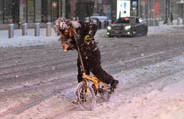
New Yorkers awoke on Saturday morning to a sight that has become increasingly rare in recent years: a city draped in a pristine, albeit disruptive, blanket of white. A powerful winter storm swept through the Tri-State area overnight, delivering the most significant snowfall the region has seen in nearly four years and transforming the post-Christmas landscape into a scene of icy chaos.
The storm, which began hammering the region on Friday evening, dropped heavy snow at rates of one to two inches per hour during its peak, leaving commuters and travellers scrambling. While the system began to taper off by early Saturday, its impact was undeniable.
The National Weather Service (NWS) recorded 4.3 inches of snow in Central Park by 7:00 am—a figure that, while modest by historical standards, marks the first time the city's iconic park has seen more than four inches in a single event since January 2022.
Commuter Chaos and Travel Disruption Across the Region
The timing of the storm, arriving just as millions were returning from holiday celebrations, could hardly have been worse. Roads across the Tri-State area quickly became treacherous, with sleet and freezing rain complicating efforts to keep major arteries clear.
In New York City, the Sanitation Department deployed its fleet of salt spreaders and ploughs in a race against the plunging temperatures, but slick conditions remained a hazard well into the morning.
Public transport was not spared the storm's wrath. The Metropolitan Transportation Authority (MTA) reported system-wide delays as crews battled to de-ice tracks and clear platforms. While the city's subway system remained largely operational, above-ground lines faced significant slowdowns.
Further afield, air travel was severely impacted, with hundreds of cancellations reported at JFK, LaGuardia, and Newark airports, leaving weary holidaymakers stranded in terminals as airlines struggled to clear the backlog.
The situation was even more acute in the suburbs. In Connecticut and the Hudson Valley, where the snowfall was heaviest, residents faced totals approaching double digits. New Fairfield, Connecticut, recorded an impressive 9.1 inches, while Meriden saw 9.0 inches, creating challenging conditions for local emergency services.
In contrast, warmer air mixing into the system kept totals lower to the south and west, with Newark seeing just 2.5 inches and parts of Long Island varying wildly from 6.8 inches in North Patchogue to under two inches in Nassau County.
A Stark Reminder of Winter's Volatility
This latest weather event serves as a stark reminder of the region's increasingly erratic winter climate. For a city that had gone nearly two years without meaningful snowfall prior to early 2024, the sudden return of winter weather has been a shock to the system.
Meteorologist Jeff Smith described the storm as an 'Alberta Clipper on steroids', supercharged by Pacific energy and colliding with cold air over the Northeast—a recipe for the intense, fast-moving burst of precipitation that residents experienced.
Authorities remain on high alert as temperatures are forecast to stay below freezing throughout the weekend, turning slush into dangerous black ice.
Governor Kathy Hochul of New York and Acting Governor Tahesha Way of New Jersey had both declared states of emergency ahead of the storm, urging residents to stay off the roads—a warning that remains pertinent as the cleanup continues.
As the clouds clear and the sun returns on Sunday, temperatures are expected to rise, offering some respite. However, for now, New York City remains in the grip of its first proper winter storm in years, a reminder that even in an era of changing climates, nature can still deliver a formidable surprise.
© Copyright IBTimes 2025. All rights reserved.
- MOST POPULAR IN World