

Iceland 2011: Ash cloud threatens European airspace
A volcanic ash cloud produced by Iceland's most active volcano is expected to reach Scotland by the early hours of Tuesday morning, the Met Office has said.
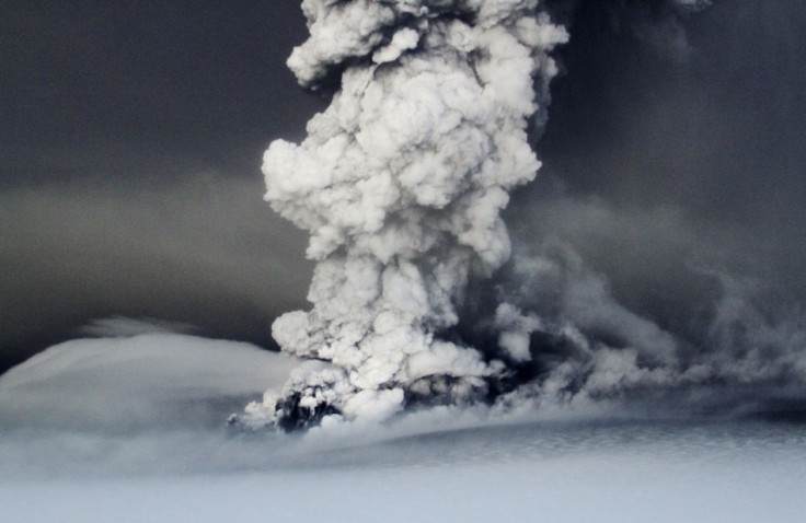
Other European nations are monitoring the impact on their air routes from the giant cloud which has sent a plume of smoke and ash 12 miles into the air.
The largest eruption by the Grimsvotn volcano in 100 years has led Icelandic air traffic control to close Keflavik airport, the country's main hub, and enforce a no-fly zone around the volcano.
The cloud had also begun to drift over the capital Reykjavik by late Sunday evening and the civil aviation authority said the prospects for re-opening the main international airport on Monday were not good.
Europe's air traffic control organisation warned that ash could spread southwards.
"Ash cloud is expected to reach North Scotland on Tuesday 24th May. If volcanic emissions continue with [the] same intensity, cloud might reach west French airspace and north Spain on Thursday 26th May," Eurocontrol said in a traffic bulletin.
The event comes a year after ash from the Eyjafjallajokull volcano spread across Europe, causing huge disruption.
Experts said a repeat of last year's six-day closure of airspace, which also hit trans-Atlantic flights, was unlikely. Although airlines have been warned the new ash cloud will drift.
So far Iceland, particularly the towns and villages to the south and east of the Grimsvotn volcano, have suffered most. Day turned to night when a thick cloud of ash descended on the area, covering cars and buildings.
The Grimsvotn volcano, which lies beneath the ice of the uninhabited Vatnajokull glacier in south-east Iceland, began erupting on Saturday.
University of Iceland geophysicist Pall Einarsson said the eruption was on a different scale to the one in Iceland last year.
"It is not likely to be anything on the scale that was produced last year when the Eyjafjallajokull volcano erupted," he was quoted as saying.
"That was an unusual volcano, an unusual ash size distribution and unusual weather pattern, which all conspired together to make life difficult in Europe."
The ash particles from this eruption are said to be larger than last year, and as a result fall to the ground more quickly.
Iceland's meteorological office said the plume from Grimsvotn, which last exploded in 2004, had fallen in height from a peak of about 25 km (16 miles) in the hours after the eruption and was now holding steady.
"It has been steady all night just below 10 kilometres," met office forecaster Teitur Arason said, adding current wind conditions were spreading the ashes in separate directions.
"The winds are a two chapter story. The winds high in the air, above 25,000 feet or there about, are southeasterly, so that ash is blow to the north and then later to the east.
"But at lower levels, the winds are northerly and therefore those ashes are blowing southward."
The eruption was much stronger than the one at a volcano further south last year which closed European airspace and halted transatlantic flights last April, due to worries that particles could get into aircraft engines and cause accidents.
"It could lead to some disruption, but only for a very limited time and only over a very limited area," said University of Iceland Professor of Geophysics Magnus Tumi Gudmundsson.
"We see some signs that the (eruption's) power is declining a bit, but it is still quite powerful," he said, adding that the eruption was the most violent at the volcano since 1873.
© Copyright IBTimes 2025. All rights reserved.
- MOST POPULAR IN Travel


