

NASA Is Stress-Testing Mars Tech in Earth's Harshest Deserts — And the Results Are Wild
NASA is taking its newest Mars exploration technologies out of the lab and into Earth's most brutal deserts, pushing drones, walking robots and experimental flyers through scorching heat, shifting dunes and barren terrain to see whether they can survive — and navigate — on Mars.
From Death Valley's towering sand ridges to the bone-dry plains of New Mexico's White Sands, engineers are discovering that the Red Planet's closest analogues on Earth deliver lessons no simulation can match.
Why Earth Deserts and Not Simulations?
The surface features of Mars are hazardous: miles of dunes, flat, barren soils with no landmarks, and terrain that is random, which may disorient the navigation system, making satellite images and simulations insufficient for holistic terrain visibility and predictability.
Given these challenges, NASA resorted to Earth analogues such as Death Valley and the Mojave Desert in California, and White Sands in New Mexico, which pose real challenges and risks. NASA Jet Propulsion Laboratory (JPL) has endeavoured to provide an in-depth examination of GE's information-sharing framework. NASA Jet Propulsion Laboratory (JPL) has conducted a detailed analysis of the information-sharing system in GE.
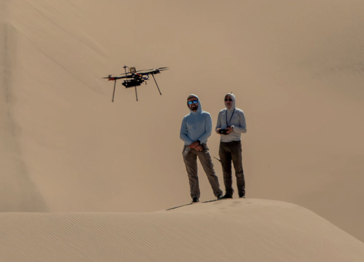
Engineers deployed three research drones for trials in Death Valley and the Dumont Dunes region of the Mojave, in the heat and on the moving dunes, as part of the Mars exploration program 2025 test campaign.
Drones Return — With Crucial Lessons Learned
The drones, tested in a project called Extended Robust Aerial Autonomy, encounter the same challenge that grounded the agency's previous Martian rotorcraft: the visual-navigation system's failure over bland, featureless terrain. During its last flights, the Ingenuity helicopter had difficulty traversing Martian dunes without identifiable surface markings, rendering visual odometry almost useless.
During the desert tests, the temperatures in Death Valley reached 45 °C (113 °F). However, the drones flew, enabling engineers to test new software, camera-filter combinations, and landing-site algorithms under extreme conditions and on a land-simulation surface that simulates Mars.
The outcome: a more thorough comprehension of how to navigate future rotorcraft safely through Martian sand or rocky terrain, and a lesson that real field data is usually more difficult and informative than simulation.
According to JPL geologist Nathan Williams, field tests provide you with a much broader view than just the computer models and the few satellite images.
He added: 'Scientifically interesting features aren't always located in the most benign places, so we want to be prepared to explore even more challenging terrains than Ingenuity did.'
Beyond Flying: Robots That Walk, Gliders That Survey
Experiments were not limited to flying machines. At White Sands National Park in New Mexico, a team of engineers launched a quadruped robot named LASSIE-M (Legged Autonomous Surface Science in Analogue Environments for Mars) — a robo-dog capable of scanning rocky or sandy landscapes that could be challenging for wheeled rovers. Its legs have sensors that detect surface rigidity or instability, enabling it to adjust its gait and warn mission control of hazardous terrain.
Moreover, the Langley Research Centre developed a half-scale prototype of a winged flyer, MERF (Mars Electric Reusable Flyer), at a test field in Virginia. It aims to integrate vertical take-off and landing with gliding, providing Martian explorers with long-range vertical access and survey capability not attainable by rotorcraft.
All of these projects indicate a broader change: in future Mars missions, rovers and helicopters may no longer be relied upon. However, a fleet of flying scouts, walking robots, and gliders may be introduced, each designed to perform a specific task and operate within a particular environment, thereby enhancing the prospects for space missions.
© Copyright IBTimes 2025. All rights reserved.
- MOST POPULAR IN World


