Nasa Unveils First Topographic Map of Moon
The Nasa science team has released the highest resolution topographic map of the moon ever created.
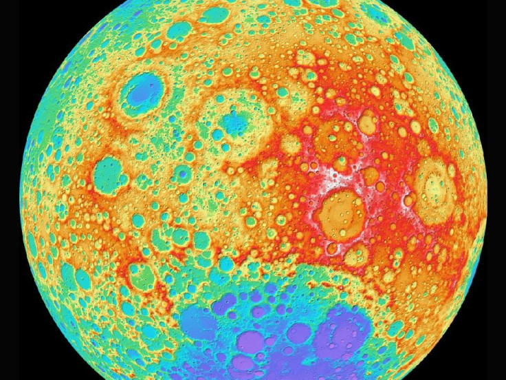
The new map, taken with the help of high-end cameras, shows the surface of the moon along with craters and the mountains, at a pixel scale close to 100 metres (328 feet). According to the scientists, almost two football fields can be placed side-by-side with a single measure of elevation (one pixel).
Using the technique of digital photogrammetry - a practice of determining the geometric properties of objects from photographic images - the map was created using a "3D effect" and a laser scanner. Due to the limitations of instruments on previous missions, a global map of the moon's topography (at high resolutions) did not exist until now.
The new map, from Arizona State University in Tempe, using the Lunar Reconnaissance Orbiter (LRO) Wide Angle Camera and the Lunar Orbiter Laser Altimeter (LOLA) instrument can now accurately portray the shape of the entire moon at high resolution.
"Our new topographic view of the moon provides the dataset that lunar scientists have waited for since the Apollo era," Mark Robinson, principal Investigator of the Lunar Reconnaissance Orbiter Camera (LROC) from Arizona State University in Tempe, said.
"We can now determine slopes of all major geologic terrains on the moon at 100 metre scale. Determine how the crust has deformed, better understand impact crater mechanics, investigate the nature of volcanic features, and better plan future robotic and human missions to the moon," added Mark.
Called the Global Lunar DTM 100 m topographic model (GLD100), the map was created based on data acquired by LRO's WAC, which is part of the LROC imaging system. The LROC imaging system consists of two Narrow Angle Cameras (NACs) to provide high-resolution images and the WAC to provide 100-metre resolution images in seven colour bands over a 57-kilometre (35-mile) swath.
Though the current model incorporates the first year of stereo imaging, for future purposes data of another year can be added to the solution. Additional changes will improve the sharpness and also fill in very small gaps that exist in the current map.
The LRO spacecraft is managed by Nasa's Goddard Space Flight Center in Greenbelt, Md., for Nasa's Science Mission Directorate in Washington.
© Copyright IBTimes 2025. All rights reserved.
- MOST POPULAR IN Science