

Satellite images show formation of new land at Atchafalaya River in Louisiana
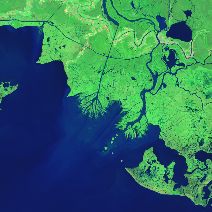
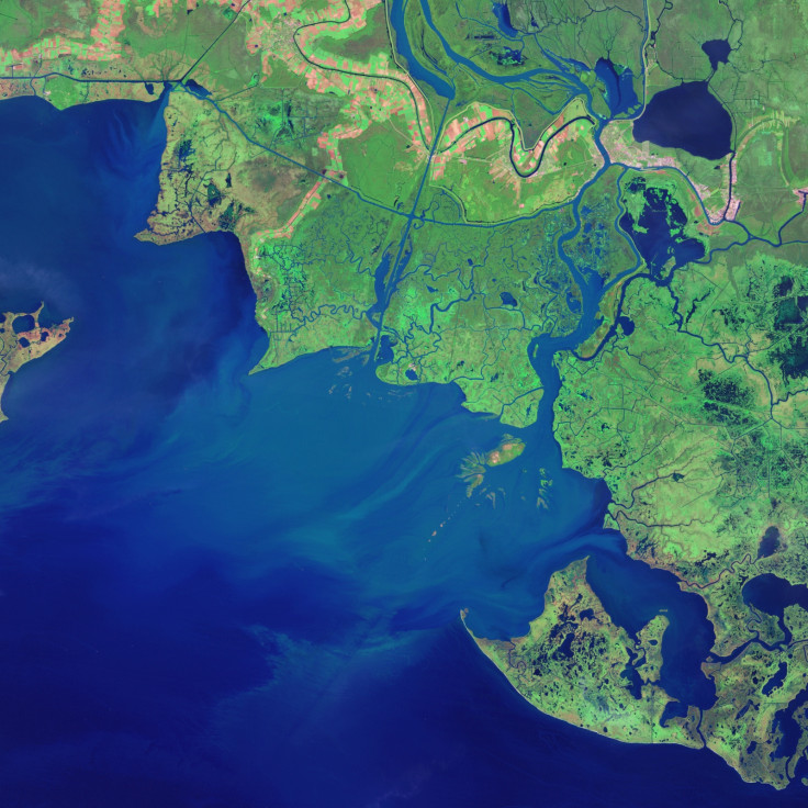
Satellite images have captured the formation of new land taking shape at the mouth of the Atchafalaya River in Louisiana.
Researchers are hoping to learn from the natural process to build land and preserve marshlands along the Mississippi River delta which is losing ground.
Satellite imagery from Landsat shows two new deltas protruding into the Gulf of Mexico, one fed by the Atchafalaya and the other from the nearby Wax Lake Outlet.
The Atchafalaya delta is growing at about 1.6 sq km per year, and the Wax Lake delta at 1.2 sq km each year.
The difference in growth is due to regular dredging and channel widening on the lower Atchafalaya, which delivers extra sediment to its delta. The untouched Wax Lake delta is more natural in character, with a more symmetric, lobate shape.
"We are looking carefully at the Wax Lake and Atchafalaya deltas as models for building new land and preserving some of our coastal marshlands," Louisiana State University coastal studies researcher Harry Roberts told Nasa's Earth Observatory, which released the images.
By similarly diverting significant portions of the water and sediment from the main channel of the Mississippi River into adjacent wetlands, lakes and bays, a significant part of Louisiana's coastal plain can be saved, the researchers believe.
It is well known that Louisiana is sinking with multiple square miles lost per year due to many natural processes besides the lack of sediment coming down after the damming of the Mississippi river.
Since the 1950s, geologists have noticed a couple of spots in the Atchafalaya Bay where land was forming. It was in 1973 that bits of land were sighted as rising above the waterline.
The Atchafalaya is a distributary of the Mississippi River that connects to the "Big Muddy" in south central Louisiana near Simmesport. Wax Lake Outlet, an artificial channel designed to reduce the severity of floods in Morgan City, delivers about 40% of the Atchafalaya's water into the bay.
Floods and hurricanes have influenced the growth of the deltas varyingly. Floods transport large volumes of extra sediment to Atchafalaya Bay, while hurricanes redistribute sediment within the bay and transport it offshore into deeper waters.
© Copyright IBTimes 2025. All rights reserved.
- MOST READ


