

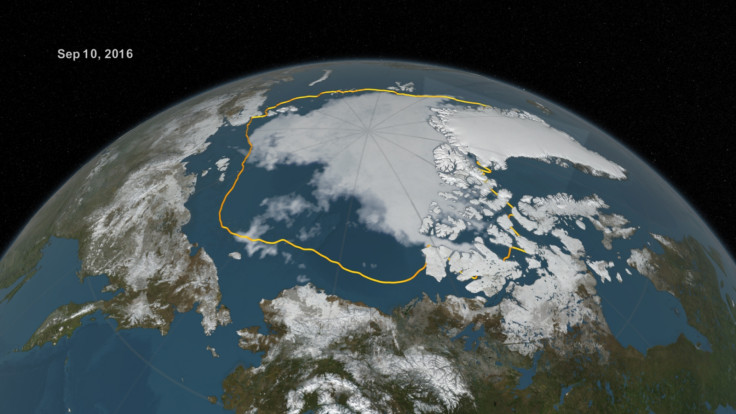
Arctic ice cover has reached its second lowest level ever recorded despite cold summer
Ice cover on 10 September was just 4.14 million sq/km – the same amount recorded in 2007.

Arctic ice cover has reached its second lowest level ever recorded, with preliminary measurements showing just 4.14 million sq/km (1.60 million sq/m) of ice extent on 10 September. This is slightly less than the previous second lowest level in 2007, when sea ice covered 4.15 million sq/km.
The measurements were taken by scientists at Nasa and the National Snow and Ice Data Center (NSIDC). Every year, Arctic ice cover expands in autumn and winter and retreats in the spring and summer, with September having the lowest levels. The lowest level ever recorded was on 17 September 2012, when ice covered just 3.39 million sq/km.
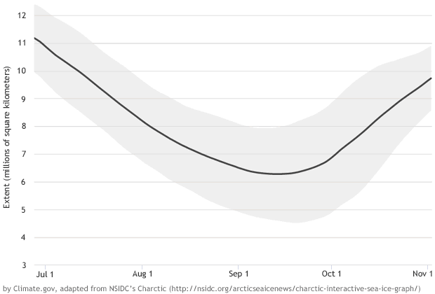
This year's low levels are particularly surprising because it was a cool and cloudy summer. "Historically, such weather conditions slow down the summer ice loss, but we still got down to essentially a tie for second lowest in the satellite record," said NSIDC director Mark Serreze.
Data showed that in the first 10 days of September, the Arctic lost ice at a faster rate than average, with 34,100 sq/km disappearing every day – just under double the long-term average of 21,000 sq/km. Because the air in September is cooler and there is less surface melt, it is thought this acceleration in ice loss is down to heat in the upper ocean.
It is also thought there was more thin ice at the start of spring, meaning less energy was required for it to melt away. "In the past, we had this remaining sea ice pack that was mostly thick, old ice. But now everything is more jumbled up, which makes it less resistant to melt, so even late in the season you can get weather conditions that give it a final kick," Nasa's Walt Meier said.
Ted Scambos, lead scientist with the NSIDC, warned we should expect more record lows in the future: "It really suggests that in the next few years, with more typical warmer conditions, we will see some very dramatic further losses," he said.
Claire Parkinson, main author of the forthcoming study, said: "When you think of the temperature records, it's common to hear the statement that even when temperatures are increasing, you do expect a record cold here or there every once in a while. To think that in this record of Arctic sea ice that goes back to the late 1970s, since 1986 there hasn't been a single record high in any month of the year, and yet, over that same period, there have been 75 record lows. It's just an incredible contrast."
© Copyright IBTimes 2025. All rights reserved.
- MOST READ


