

El Niño to bring extreme weather across world, could break heat records: UN
El Niño is the natural warming of parts of the Pacific Ocean that changes weather worldwide.

The United Nations has warned that the likelihood of El Niño development this year could have a severe impact on several parts of the world.
According to the UN's World Meteorological Organisation, it could trigger more extreme weather and climate events across the world.
"The world should prepare for the development of El Niño, which is often associated with increased heat, drought or rainfall in different parts of the world," said WMO secretary-general Petteri Taalas.
El Niño is the natural warming of parts of the Pacific Ocean that changes weather worldwide. It is associated with an increase in temperature globally. The hottest year in recorded history, 2016, was an El Niño year.
One of the best ways to forecast the ENSO cycle is to track sub surface warming in the Pacific. This animation shows the end of La Nina (blue-cool colors fading in the east Tropical Pacific) and the eastward surge of warm subsurface water into the E. Pacific. El Nino is near! pic.twitter.com/Ciehn16kKk
— Jeff Berardelli (@WeatherProf) May 5, 2023
It is part of a larger phenomenon called the El Niño-Southern Oscillation (ENSO). El Niño is the "warm phase" of ENSO, while La Niña is its "cool phase," according to the National Geographic Society. It is typically concentrated in the central-east equatorial Pacific, and its effects peak during December.
The planet is already 1.2°C warmer than in pre-industrial times, and El Niño's return is only expected to make the situation worse this year. However, there is no evidence to suggest that climate change has affected El Niño events.
The UN experts fear that it could lead to a record spike in temperatures in some regions. According to WMO, there is a 60% chance that El Niño could develop by the end of July, and an 80% chance it could happen by the end of September.
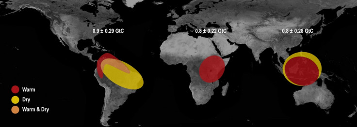
It could also bring some respite to drought-hit regions in the Horn of Africa. At the same time, it can lead to severe drought in Australia, Indonesia, and parts of southern Asia. El Niño's warm waters can also fuel hurricanes in the central and eastern Pacific Ocean.
There is about 60% chance for the onset of #ElNino during May-July, rising to 70-80% during July- Sept.#ElNiño affects weather and climate patterns in many parts of the world and is typically associated with higher global temperatures.
— World Meteorological Organization (@WMO) May 3, 2023
🔗https://t.co/XfRP2CaH9C pic.twitter.com/5TCUrV0nkC
"This highlights the need for the UN Early Warnings for All initiative to keep people safe," added Taalas. However, its effects will take some time to kick in, implying that 2024 could be warmer than 2023.
Earlier, the UK Met Office had also warned of the severe impacts that El Niño might have this year. Scientists warned that 2023 could see unprecedented heat waves due to the return of the El Niño climate phenomenon later this year.
"It's very likely that the next big El Niño could take us over 1.5°C," said Prof. Adam Scaife of the UK Met Office. "You put those two things together, and we are likely to see unprecedented heatwaves during the next El Niño."
"The probability of having the first year at 1.5ºC in the next five-year period is now about 50:50," he added.
Episodes of El Niño typically last for nine to 12 months; however, sometimes they can last for years. It occurs every two to seven years.
It not only affects global climate patterns significantly, but also the marine ecosystem. During El Niño, nutrient-rich cold water of the ocean does not come to the surface, which has a disastrous impact on the fish population.
The world had been witnessing La Nina conditions since 2020, whose cooling effect kept global temperatures under control. La Niña has the opposite effect of El Niño. It keeps the temperatures under control and supports more marine life. With La Niña giving way to El Niño conditions, this is going to change and the world needs to prepare to face it.
According to a report in The Conversation, El Niño can lead to a 0.2°C increase in Earth's average temperature. This implies that the planet's temperature can temporarily exceed the 1.5°C threshold of the Paris Agreement once El Nino hits its peak. However, nothing can be said for sure currently.
© Copyright IBTimes 2025. All rights reserved.
- MOST READ


