Mystery of Google Maps 'sunken ghost plane' is finally solved

Google Maps users and authorities have been stumped by mystery of the haunting image of an aircraft that appears to be lying at the bottom of a lake in the US, but now experts have solved the puzzling discovery.
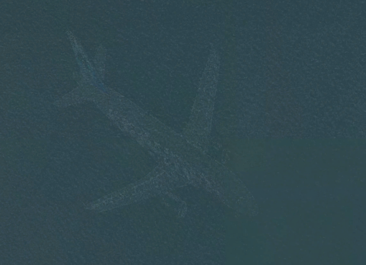
Conspiracy theorists and speculators were sent into a tizzy when the ghostly image of a passenger plane 'submerged' beneath the waters of Lake Harriet in Minneapolis, US, appeared online. The intact aircraft looked convincingly sunk in the lake and with no records of a plane going missing or history of a crash in the area the mystery thickened.
But not for long. Experts refusing to be carried away with the romantic idea of a ghost plane took a breath didn't dial the Scooby Gang, and instead sought answers with Google's satellite imagery technology. By doing this, they found the answer to the so-called mysterious ghost wreck.
A Google Maps spokesperson simply explained: "In short, each satellite image you see on the map is actually a compilation of several images. Fast-moving objects like planes often show up in only one of the many image we use for a given area."
With the lake located only five miles from Minneapolis-St Paul Airport and on the flight path for planes departing and arriving at the busy airport this backs up the claim made by Google as to why the plane appears on the map. Also, the undamaged outline of the plane gives another huge clue that it was unlikely a plane crashed and sunk in the lake without so much as a wing cracking.
It just happens to be a perfectly-timed snapshot by the satellite that places the plane in the lake. As to why it is faded and looks like its underwater is another case of coincidence as the stitching together of multiple images and the speed the plane was travelling would result in a blurry outcome. Ever tried taking a picture of a speeding car? You'll know it isn't sharp – now try taking that from space and something moving five-times faster. Case solved.
If you want to see the 'sunken plane' for yourself go to Google Maps and type in Lake Harriet. Then switch to Google Earth view and zoom in. You'll find the faded image just to the right of the drop pin.
© Copyright IBTimes 2025. All rights reserved.
- MOST POPULAR IN Technology