

Nasa releases new breathtaking images of trillion-ton iceberg and other Antarctic ice shelves
One of the most alarming images that was taken this year shows the Larcen C ice shelf breaking off and drifting to sea.
Nasa's Operation IceBridge successfully kicked off its 2017 survey of Antarctic sea and land ice in October. For the first time in its long run, the mission that charts polar ice, will launch two different Antarctic flights from two continents — South America and Antarctica.
The space agency released a number of pictures of the icy terrain it collected through its air-borne project. The images detail the stunning beauty of the Antarctic ice shelves as well as the devastation caused by melting ice.
"This is an exciting and ambitious undertaking for IceBridge, as the dual campaigns will allow us to continue our surveys of important areas near the Antarctic Peninsula and greatly expand our coverage into the vast expanse of East Antarctica," said Nathan Kurtz, IceBridge's project scientist at Goddard Space Flight Center.
One of the most alarming images that was taken this year shows the Larcen C ice shelf breaking off and drifting to sea. The iceberg that broke off in July is the size of Delaware and reportedly weighs over a trillion tonnes. The ice shelf that floated off into the sea is 600ft thick and will not really contribute to sea levels rising because it has already been floating on the sea as an ice shelf for some time now, says Nasa. However, scientists are still working out how this will affect the flow rate of the shelf itself.
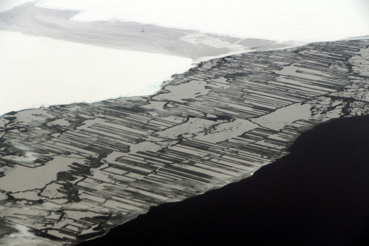
The image below, shot at the Weddell Sea off the Antarctic Peninsula, shows the stark difference between sea ice and land ice. The geometric patterns similar to a zipper interlocking system are a result of what Nasa calls "finger rafting" and happens when two floes of thin ice collide. The ice must be no thicker than 20cm for this to happen.
This image shared by Nasa on Twitter shows an iceberg at McMurdo Sound.
From yesterday's #IceBridge flight: An Iceberg in McMurdo Sound, #Antarctica pic.twitter.com/N6CVN64lvZ
— NASA ICE (@NASA_ICE) November 29, 2017
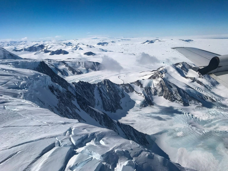
Another image of the McMurdo: Mackay Glacier Tongue, Transantarctic Mountains in Antarctica.
From yesterday's #IceBridge flight out of McMurdo: Mackay Glacier Tongue, Transantarctic Mountains pic.twitter.com/5qD274IYPF
— NASA ICE (@NASA_ICE) November 29, 2017
This image was shot over the Antarctic Peninsula, crossing the Crescent Scarp, near Fleming Glacier.
From yesterday's #IceBridge flight over the Antarctic Peninsula: Crossing the Crescent Scarp, near Fleming Glacier pic.twitter.com/zvYYLyYdZp
— NASA ICE (@NASA_ICE) November 22, 2017
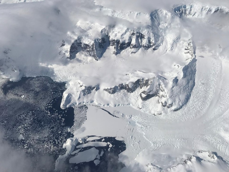
A shot of the Triune Peaks, near what is left of the Wordie Ice Shelf.
From yesterday's #IceBridge flight over the Antarctic Peninsula: The Triune Peaks, flanking the remnants of the Wordie Ice Shelf pic.twitter.com/ittZFStZWh
— NASA ICE (@NASA_ICE) November 22, 2017
This image shows the point where Larsen C broke off.
From yesterday's #IceBridge flight over the south Antarctic Peninsula: The Lower Clifford Glacier in the background, with the Larsen-D ice shelf
— NASA ICE (@NASA_ICE) November 22, 2017
in the foreground pic.twitter.com/meoZcrLUSU
The Antarctic ice melt is something that Nasa will continue to study as part of IceBridge every year between October and November.
- MOST READ


