

Zealandia: All you need to know about the long lost continent
New Zealand is the major habitable administrative set up under Zealandia.
Zealandia has recently been given the status of a continent by several geologists who say that the long lost continent is submerged under water. While there is no formal recognition of the same by the New Zealand government, which is the major habitable administration on Zealandia; there is, however, wide interest in the media about the continent.
IBTimes UK tells you all you need to know about the long lost continent.
Where is it located?
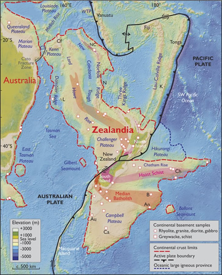
It is located on the southwest Pacific Ocean mostly surrounding, in what is the current land mass of New Zealand and its adjoining islands.
How big is it?
The total area is estimated to be approximately 4,920,000 square km of which 93% remains submerged below the Pacific Ocean. In terms of size, it is the world's largest current micro-continent, about half the size of the Australian continent..
Which habitable areas currently fall under Zealandia?
- New Zealand
- New Caledonia
- Norfolk Island
- Lord Howe Island Group
What is its geography like?
- The continent is largely made up of two parallel ridges, separated by a failed rift. The ridges rise above the sea floor with infrequent rocky islands rising above sea level
- Scientists identify two main portions of the continent, North Zealandia (or Western Province) and South Zealandia (or Eastern Province)
- Compared to other continents it has much wider and deeper continental shelves
- The highest point of Zealandia is Aoraki–Mount Cook at 3724 m
- The region has elevated bathymetry relative to surrounding oceanic crust, diverse and silica-rich rocks, and relatively thick and low-velocity crustal structure
- Volcanism is widespread across Zealandia but generally of low volume
Why is it being called long lost?
Previously, it was thought that the crust underneath the ocean in this area was fragmented into various bits. But, new satellite-based gravity maps of the ancient seafloor make it clear that the region is a continuous whole continent.
Geolologists say that if Earth's solid surface had first been mapped like how Mars and Venus are mapped now, Zealandia would have been investigated and identified as one of Earth's continents.
Why is its continent status still vague?
Geologists have, over the years, identified seven continents in all -- Europe, North America, South America, Africa, Asia, Australia and Antarctica. Surprisingly, there is no clear definition of what makes a continent except some geographical requirements, which has led to several conflicted opinions for instance the case of Eurasia, where many geologists think Asia and Europe are one entity as it is a single rigid megablock.
Now, the Geological Society of America has stated that Zealandia is a geological continent in itself rather than a micro-continent or continental fragment. According to geo-political arrangements parts of Zealandia, mainly New Zealand is grouped under Oceania -- the region encompassing the Australian continent, New Zealand and various islands in the Pacific Ocean that are not included in the seven-continent model.
The New Zealand government has not officially responded to the recognition of Zealandia.
© Copyright IBTimes 2025. All rights reserved.
- MOST READ


