

Mexico hit by massive 8.1 'earthquake of the century' triggering tsunami warning
Tsunami waves possible on Pacific coasts of Central America, including Guatemala, El Salvador, Costa Rica, Nicaragua, Panama and Honduras.

An earthquake of magnitude 8.1 has struck off the coast of southern Mexico, triggering a tsunami warning. Mexico's president says that the magnitude of the earthquake that hit the country is 8.2, the biggest the country has seen in a century.
Enrique Pena Nieto confirmed that at least five people have died in the temblor. He also said that major damage has been caused and that 1 million initially had been without power following the quake, but that electricity had been restored to 800,000 of them.
He said that there have been 62 aftershocks and it's possible one as strong as 7.2 could hit.
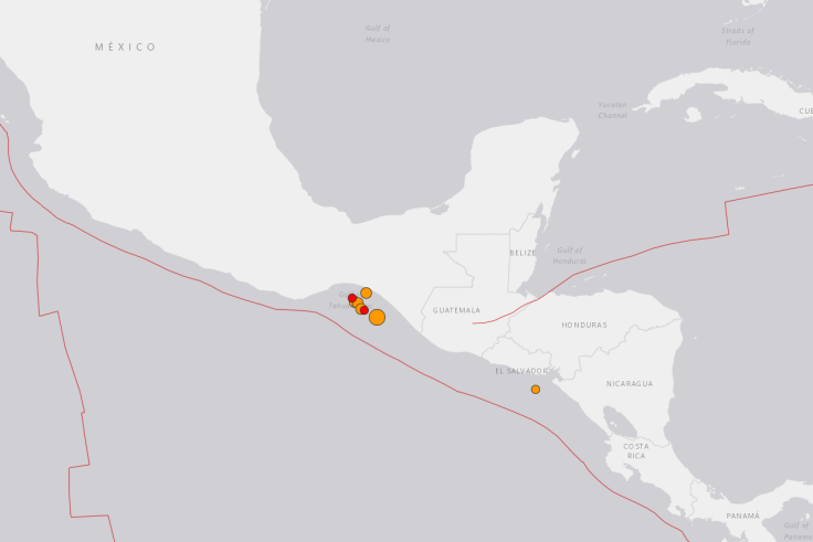
The US Geological Survey (USGS) said the quake struck at 11:49pm local time on Thursday (8 September) and its epicenter was 165km (102 miles) west of Tapachula in Chiapas state, not far from Guatemala. It had a depth of 35km (22 miles). USGS reported that the quake had a magnitude of 8.1.
The quake was so powerful that frightened residents in Mexico City more than 1,000km (650 miles) away fled buildings as they swayed violently.
The US Tsunami Warning System said hazardous waves were possible on the Pacific coasts of several Central American countries, including Guatemala, El Salvador, Costa Rica, Nicaragua, Panama and Honduras, within three hours. There was no tsunami threat for the US West Coast, but the warning system said waves could reach Mexico and as far as Ecuador.
Chiapas Govenor Manuel Velasco told television station Televisa the rooves of homes and a shopping center had collapsed in San Cristobal. "There are damages in hospitals that have lost energy. Homes, schools and hospitals have been affected."
Civil Defense in Chiapas said on its Twitter account that its personnel were in the streets aiding people and warned residents to prepare for aftershocks.
Guatemala President Jimmy Morales spoke on national television to call for calm while emergency crews checked for damage. "We have reports of some damage and the death of one person, even though we still don't have details." He said the unconfirmed death occurred in San Marcos state near the border with Mexico.
Lucy Jones, a seismologist in California who works with the U.S. Geological Survey, said such as quake was to be expected.
"Off the west coast of Mexico is what's called the subduction zone, the Pacific Plate is moving under the Mexican peninsula," she said. "It's a very flat fault, so it's a place that has big earthquakes relatively often because of that. There's likely to be a small tsunami going to the southwest. It's not going to be coming up and affecting California or Hawaii. For tsunami generation, an 8 is relatively small."
The Pacific Tsunami Warning Center says waves of 1 meter (3.3 feet) above the tide level were measured off Salina Cruz. Smaller tsunami waves were observed on the coast or measured by ocean gauges in several other places. The center's forecast said Ecuador, El Salvador and Guatemala could see waves of a meter or less. No threat was posed to Hawaii and the western and South Pacific.


© Copyright IBTimes 2025. All rights reserved.
- MOST READ


