

Peru's mysterious ring-shaped geoglyphs may symbolise ancient trade flows
Large circles in southern Peru appear to represent trade exchanges more than 1,000 years ago.

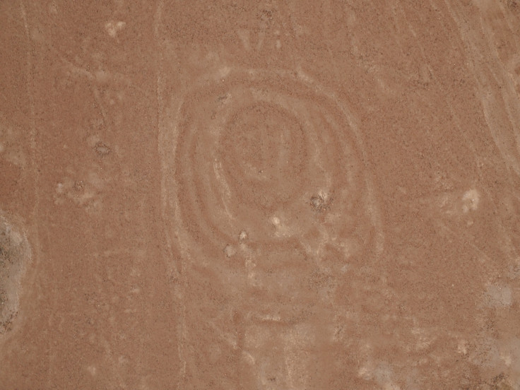
Dozens of ring-shaped geoglyphs have been been mapped for the first time near the ancient town of Quilcapampa, Peru. The mysterious lines, created on the surface of the ground by ancient inhabitants, are in close proximity to the pathways that were used in the past for trade.
Geoglyphs have always fascinated archaeologists. These strange designs "scratched" on the Earth's surface are sometimes thought to have been made by pre-Columbian populations so that gods could see them from the sky.
The most famous geoglyphs are the "Nazca lines", which are found in the Nazca desert, 400km from the capital Lima, and depict animals, plants and enigmatic geometric shapes. They date back to between 500BC and 500AD, and were added to the Unesco World Heritage list over twenty years ago.
However, there are many more geoglyphs in Peru that remain less documented and poorly understood.
"For the most part, these other geoglyphs have been mentioned, focusing on the most spectacular in passing, without much thought given to where they are in the landscape," Justin Jennings, a curator at the Royal Ontario Museum in Toronto and one of the team's leaders, told IBTimes UK.
"What is new about our work is that we are mapping all of the visible geoglyphs and putting them into context with the environment and other cultural features. We see what geoglyphs are next to others, and can conclusively show, for example, that the geoglyphs are associated with ancient trails."
Symbolism in the shapes
These latest geoglyphs, found in the Sihuas Valley appear to have a symbolic purpose, like other geoglyphs identified in Peru. They depict individual circles or several intertwined rings - where smaller circles are embedded in larger ones.
The rings nearly all measure between 2 and 4 metres in diameter, but the intertwined ring-shape is covering a surface of over 800 square metres. To map and study all the different shapes in relation to one another, it was necessary to use sophisticated technologies, such as satellite imagery and unmanned drones, combined with ground surveys. The complete findings will soon be published in Journal of Archaeological Science: Reports.
The researchers explain that the circular shapes potentially symbolised the flow of people and goods on the trade paths near Quilcapampa. More than a thousand years ago, the city was a key commercial hub, where different populations interacted and a flow of merchandise passed through. Although we we may never know the exact signification of the geoglyphs, this is a clue to understanding their purpose.
"Their meaning, like all things Pre-Columbian, is elusive. Yet, they seem to have been made at a time of mounting long-distance trade - most appear to date from about AD 600-1500. The largest geoglyphs are concentric circles, perhaps reflecting the importance of circulation of the essence of life between places. This belief has deep roots in the Andes and likely helped to maintain links between far-flung groups that exchanged goods with each other", Jennings concluded.
© Copyright IBTimes 2025. All rights reserved.
- MOST READ


