Coastal Flood Advisory Issued for 3 NJ Counties — Here's When It Ends
NJ braces for coastal flooding as storm brings heavy rain and strong winds through Thursday

The National Weather Service (NWS) has issued a Coastal Flood Advisory for Ocean, Atlantic, and Cape May counties in New Jersey, warning of minor to moderate flooding during high tide cycles.
The advisory, which began on the evening of Wednesday, 29 October 2025, is expected to remain in effect through Thursday evening, with the most significant impacts anticipated during the Thursday afternoon high tide.
According to Sea Isle City's official alert, the advisory is linked to a strong coastal storm system forecast to bring wind gusts up to 50 mph, heavy rainfall of up to three inches, and above-average tidal surges along the southern New Jersey coastline.
Storm System to Peak Thursday Afternoon
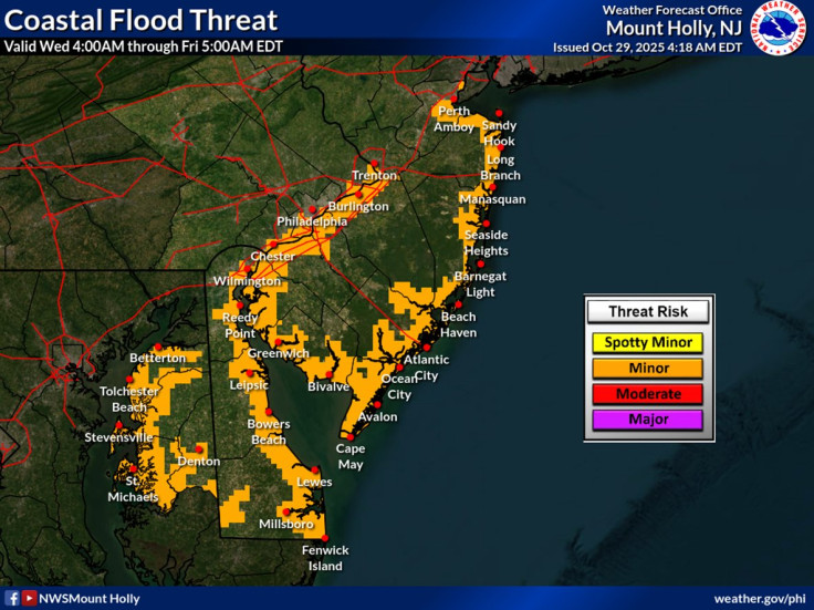
Meteorologists expect the worst of the storm to hit during the Thursday afternoon high tide, when moderate coastal flooding is most likely. The NWS has urged residents in low-lying areas to take precautions, including moving vehicles to higher ground and avoiding travel through flooded streets.
'Do not attempt to drive through standing water on the streets,' the Sea Isle City advisory warns. 'The wake your vehicle creates can damage nearby properties and gardens — and salt water can greatly damage or destroy your vehicle.'
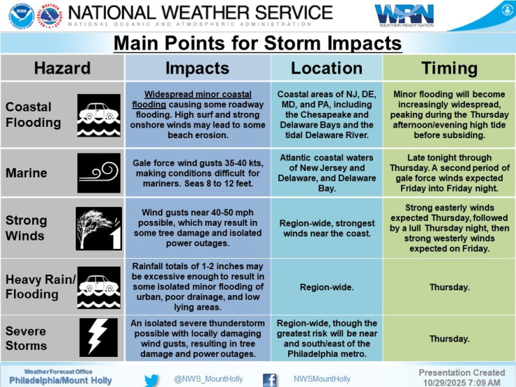
The storm is also expected to bring strong easterly winds on Thursday, shifting to westerly winds on Friday, which could exacerbate flooding and cause additional coastal erosion.
Travel and Infrastructure Concerns
The combination of heavy rain and strong winds is likely to cause localised flooding, downed tree limbs, and travel disruptions, particularly in coastal communities. According to News 12 New Jersey, gusty winds could clog sewers with fallen leaves and debris, increasing the risk of flash flooding in urban areas.
Air travel may also be affected, with delays possible at Newark Liberty International Airport and other regional hubs. Commuters are advised to monitor local forecasts and plan for slower travel conditions throughout Thursday.
Precautionary Measures and Safety Tips
Residents in affected areas are encouraged to:
- Monitor local weather updates and alerts from the NWS
- Avoid driving through flooded roadways
- Secure outdoor furniture and loose items ahead of high winds
- Move vehicles to higher ground if parked in flood-prone zones
- Prepare for potential power outages due to wind damage
The NWS has also advised mariners to exercise caution, as hazardous marine conditions are expected along the coast, with rough surf and dangerous rip currents likely through Friday.
When Will the Advisory End?
The Coastal Flood Advisory is expected to remain in effect until late Thursday evening, 30 October 2025, though the exact timing may vary depending on the storm's progression and tidal conditions.
Forecasts indicate that weather conditions should begin to improve by Friday morning, with winds shifting and rainfall tapering off. However, residual flooding, waterlogged infrastructure, and debris-related hazards may persist into the weekend, requiring ongoing cleanup and caution in low-lying areas.
As New Jersey braces for the peak of this powerful coastal storm, residents in Ocean, Atlantic, and Cape May counties are strongly urged to remain vigilant, monitor official updates, and take all necessary precautions to protect property and personal safety. With the advisory in place through Thursday evening, local authorities and emergency services remain on high alert to respond to any flooding-related incidents or disruptions.
© Copyright IBTimes 2025. All rights reserved.
- MOST POPULAR IN National