

Iceland: Holuhraun lava field biggest in 200 years, Nasa satellite images show

Iceland's Holuhraun lava field is now the biggest it has been for 200 years, covering over 84sq/km (32sq/miles).
Nasa satellite images have shown how the lava field has spread over recent months, with magma gushing from fissures north of Vatnajökull, Iceland's largest glacier.
Researchers at the University of Iceland's Institute of Earth Science say that based on data from surveillance flights, the thickness of the field is about 10m, with the centre and western parts reaching 12 and 14m deep respectively.
Nasa Earth Observatory, which released the latest images, said the Holuhraun lava flow is now the biggest since the Laki eruption in 1783–84 – an event that killed 20% of the island's population.
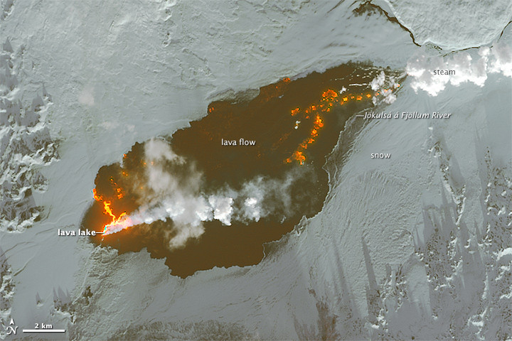
Explaining the latest image, a statement read: "The plume of steam and sulphur dioxide appears white. Newly-formed basaltic rock is black. Fresh lava is bright orange. A lava lake is visible on the western part of the lava field, and steam rises from the eastern margin where the lava meets the Jökulsá á Fjöllum river."
In comparison, the image from September last year shows how most of the lava was constrained to rivers.
The fissure continues to spew huge amounts of lava and sulphur dioxide, but current observations – including seismic activity and the sinking of the caldera – suggest it is starting to slow.
However, John Stevenson, from Edinburgh University, said: "This doesn't mean that the eruption will stop soon. Like the weakening spray from an aerosol can, the eruption rate declines exponentially. The lower the flow, the more slowly it declines."
Instead, the lava flow could continue for several more years, Nasa said.
© Copyright IBTimes 2025. All rights reserved.
- MOST READ


