

Helicopter Pilot Aman Budathoki Reports 'Extremely Frightening' 6-Metre Waves Sweeping Through Nepal
In a Himalayan valley where rivers now rise without warning, a pilot's glimpse of six metre waves captures Nepal's uneasy new normal
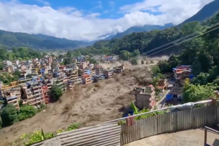
Helicopter pilot Aman Budathoki has described 'extremely frightening' waves up to six metres high tearing through river valleys in northern Nepal on Wednesday, August 26, as flash floods near the China border swept away trees, vehicles and homes and left entire villages fearing the worst.
The sudden flooding hit a stretch of the Bhotekoshi River, a volatile Himalayan waterway that cuts through steep gorges before flowing into Nepal's Bagmati Province. Early assessments from scientists suggest a chain reaction, possibly involving an earthquake, an avalanche and a temporary river blockage, may have unleashed the violent surge that residents saw racing downstream.
Pilot Describes Terrifying Wall of Water
From his helicopter cockpit, Budathoki watched the disaster unfold in real time. He told local broadcasters he first noticed a huge cloud of dust rising from the river and assumed it was a landslide.
NEPAL FLOODS: PEOPLE RUN FOR THEIR LIVES
— Subodh Kumar (@kumarsubodh_) August 26, 2026
A group of people can be seen running to safety as a fast-moving flash flood suddenly surges through the area, sweeping across the ground with powerful force.
At least 8 people have died in the floods, according to Nepal Police. pic.twitter.com/i0Ug0xBtIW
Moments later, what he had taken for dust was followed by dark, churning water loaded with rock and debris, surging through the gorge with astonishing speed. From the air, he estimated the flood waves were 'five to six metres' high, large enough to bounce vehicles around like toys and rip fully grown trees out of the riverbank.
He called the view 'extremely frightening,' a phrase that sounds almost understated when you picture a six metre wall of water in such a narrow valley. Pilots on Nepal's mountain routes see rough weather all the time, but not this sort of thing.
Scientists Probe 'Cascading Hazard'
The news came after seismologists recorded earthquake activity in the region shortly before the flood. Initial field reports suggest the quake may have shaken loose a mass of ice and rock higher up the catchment, triggering an avalanche that crashed into the Bhotekoshi.
According to Saswata Sanyal of the International Centre for Integrated Mountain Development, or ICIMOD, the incident appears to be a 'cascading hazard.' By that, he means one hazard, such as an earthquake, sets off another, such as an avalanche, which then leads to a river blockage and, finally, a sudden dam break flood.
Experts stress that this chain is still a hypothesis. Teams are now combing satellite images, seismic data and drone footage to work out the exact sequence. No single cause has been confirmed, and ICIMOD researchers say several overlapping processes may have contributed.
Nuwakot Villages Choked by Mud and Debris
Drone images from Nuwakot district, northwest of Kathmandu, show how brutally that process plays out on the ground. In several villages along the river, brown floodwater pours through fields and around concrete houses, leaving some structures half buried in mud.
🇳🇵 This is Nepal after a devastating flash flood hit key areas and one of its major rivers. 🌊
— Payall Singhh (@PayallSingh13) August 26, 2026
The terrifying visuals show the sheer scale of destruction caused by the floods.#NepalFlood #FlashFlood #Nepal #FloodAlert pic.twitter.com/2xDA2mOLsU
Local footage shows rooftops poking out of thick silt where gardens and courtyards once stood. Roads appear carved away or simply erased, with power lines hanging over new channels cut by the water. Residents can be seen picking through debris, trying to work out what might still be salvageable.
Provincial authorities in Bagmati have reported 'severe impacts' in Nuwakot and other downstream areas, though detailed figures on casualties and damage are still being collected.
Glaciers, Warming and a Rising Sense of Risk
Nepal sits in the heart of the Hindu Kush Himalaya, one of the fastest warming mountain regions on the planet. The country is laced with thousands of glaciers and glacial lakes, many of them perched above densely populated river valleys.
ICIMOD research has found that glacier ice loss across the Hindu Kush Himalaya has doubled since 2000, a startling acceleration that worries hydrologists and disaster planners alike. As glaciers shrink and destabilise, loose rock, meltwater and ice can combine in nasty ways, particularly when jolted by earthquakes.
That does not mean climate change 'caused' this specific Nepal flash flood, and scientists have been clear about that. It does mean the background conditions are getting messier, with more water in high mountain lakes and more unstable slopes hanging above communities that have very little margin for error.
What a Glacial Lake Outburst Flood Looks Like
In case you missed it, one of the main scenarios experts are considering is a Glacial Lake Outburst Flood, often shortened to GLOF. This happens when a lake that has formed at the edge of a glacier suddenly bursts its natural dam.
🇲🇦 🇳🇵 UPDATE — Nepal flood: Nepal's Tourism Board says 384 travelers are so far unaccounted for after Wednesday's (Aug. 26) Bhote Koshi flash flood — 291 foreign nationals (including 3 Americans, plus Indian, British, Malaysian, Dutch, South African and Australian tourists) and… pic.twitter.com/SCXZ0hmiwu
— 🔥🗞The Informant (@theinformant_x) August 26, 2026
The dam can be made of loose rock and ice, and it does not always fail gently. A small avalanche, a landslide, or even heavy rain can tip it over the edge. When that happens, millions of cubic metres of water can roar down valley in a matter of minutes, scouring riverbeds and smashing through bridges, houses and farmland.
Nepal's steep topography makes this particularly dangerous. There is little flat land for the water to spread out, so it stays concentrated, fast and violent, as residents along the Bhotekoshi have just been reminded.
Climate Change Questions, But Few Clear Answers Yet
Scientists have warned for years that global warming increases the likelihood of GLOFs and other high mountain disasters. Rising temperatures thin glacier ice, expand lakes and weaken the moraines that hold them in place, stacking the odds against communities downstream.
In this case, though, glaciologists are being cautious. They say the roles of the recent earthquake, any avalanche, potential river blockage and a possible glacial lake outburst are still being mapped.
What is clear is that the latest Nepal flash floods will add to pressure on regional governments to invest in early warning systems, remote monitoring and safer land use planning in exposed valleys. That kind of stuff is dull to debate in peacetime, until a six metre wave appears where a calm river used to be.
© Copyright IBTimes 2026. All rights reserved.