Weather Snow Forecast UK 2025: Brace For White Holiday As Temperatures Expect To Plummet In These Areas
Heavy snow is uncertain, but high pressure could bring clearer skies and widespread overnight frost.
As Christmas 2025 approaches, weather forecasts across the UK are showing early signs of a seasonal shift that could bring colder nights, frost, and the possibility of snow in several regions. According to the Met Office's latest long-range outlook, unsettled conditions dominated by rain are expected to ease gradually, with high pressure becoming more influential in the days leading up to Christmas.
This shift coincides with the start of astronomical winter on 21 December, when wintry conditions are more likely to take hold. WXCharts maps suggest snow showers could reach much of the UK, with Scotland, northern England, and Northern Ireland most at risk.
Where Snow Could Fall on Christmas Day
Forecasts covering the period from Friday 19 December to Sunday 28 December indicate that Scotland and Northern Ireland are likely to see more settled weather first, followed by improvements further south. While rain and showers will not disappear entirely, lighter winds and clearer skies are expected to allow temperatures to fall closer to seasonal averages, increasing the likelihood of overnight frost and morning fog.
This shift coincides with the beginning of astronomical winter on 21 December 2025, traditionally the point when colder conditions are more likely to take hold across the country.
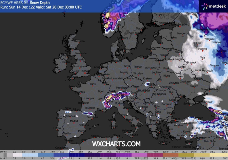
Weather charts published by WXCharts have fuelled growing speculation about a potential white Christmas, showing wintry showers extending further south than earlier projections suggested.
According to these charts, snow showers could affect large parts of the UK on Christmas Day, with Scotland, northern England, and Northern Ireland facing the highest probability.
Central regions, including parts of the Midlands, may also see wintry precipitation if temperatures dip sufficiently during showers. Even southern England, including the Home Counties, has been flagged as being near the critical '528 line' — a meteorological threshold often used to assess snow potential. Areas north of this line are more likely to experience snow rather than rain during cold spells.
That said, snow accumulation appears most likely over higher ground. Snow-depth charts currently suggest settled snow of between 2cm and 6cm across parts of the Scottish Highlands, including areas around Inverness and Aviemore. Lower elevations may experience brief flurries or sleet rather than lasting snowfall.
Temperatures, Frost and the Role of High Pressure
Minimum temperature maps for Christmas Day show near-freezing conditions across northern and central Britain, with temperatures between 0°C and 2°C forecast in Scotland, northern England, and parts of Northern Ireland. Further south, temperatures are expected to remain slightly milder, typically ranging from 4°C to 7°C, though this could drop sharply overnight under clear skies.
Low pressure continues to bring further outbreaks of rain and above-average temperatures through the next 10 days, but there are signs the pattern will break to more settled weather in the run-up to Christmas.
— Met Office (@metoffice) December 10, 2025
Here's Annie with more detail... pic.twitter.com/MIw85uTGMg
The Met Office has emphasised that high pressure is likely to dominate much of the Christmas period, bringing drier weather overall compared to earlier in December. However, this does not eliminate the risk of wintry hazards. Clear nights under high pressure often lead to widespread frost and fog, which can be slow to clear and disruptive to travel
Forecasters also caution that snowfall predictions remain highly sensitive to small changes in atmospheric conditions. Minor shifts in wind direction or temperature profiles can determine whether precipitation falls as rain, sleet, or snow — especially in marginal southern areas.
What to Expect as Christmas Nears
While confidence in widespread heavy snow remains low at this stage, the evolving forecast suggests that Christmas 2025 could feel more traditionally wintry than recent years. Northern regions have the strongest chance of snow, while much of the UK should prepare for colder nights, frosty mornings, and possible fog as high pressure settles in.
With further updates expected in the days ahead, forecasters continue to urge the public to stay informed and flexible. Whether or not snow settles on Christmas morning, the weather outlook points toward a colder, calmer festive period — a notable change from the wet and windy conditions that have dominated much of early winter.
© Copyright IBTimes 2025. All rights reserved.
- Recommended For You