California Braces for Early-Season Storm; Flash Flood Watch Issued for Most of LA County
Authorities have issued evacuation advisories for communities near recent wildfire burn scars.
Southern California is bracing for heavy rainfall as the National Weather Service (NWS) issued a flash flood watch covering significant portions of the region.
On Monday afternoon, the storm has already caused disruption in Northern California, delaying hundreds of flights at San Francisco Airport and prompting flood advisories in San Francisco, Oakland, and Napa, as reported by SFGATE.
Webcams from Mammoth Mountain and Bear Valley Resorts have captured the storm sweeping across the slopes, leaving a blanket of snow in its wake.
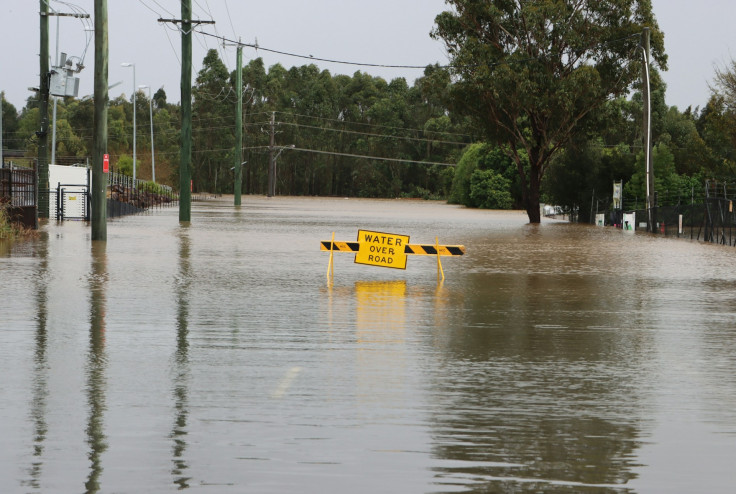
Flood Risks Across LA County and Beyond
Most of Los Angeles County, including both coastal and inland areas, is now under a flash flood watch.
NWS authorities in LA have highlighted that regions previously affected by wildfires are particularly vulnerable to flash flooding.
While the Antelope Valley faces less risk from flooding, it remains under a wind advisory that stretches to Kern County.
Similar warnings have been issued for Ventura County and parts of northern Santa Barbara County, with the watch expected to remain in effect through Tuesday afternoon.
Mountain areas in San Bernardino County, such as Crestline, Big Bear Lake, and Wrightwood, as well as inland Orange County and most of the Inland Empire, are also under watch.
Officials warned that heavy rainfall could trigger debris flows in burn scar zones, including the Bridge, Line, Apple, El Dorado, and Airport areas, while low-lying regions remain at risk of sudden flooding. Communities in the Palisades, Altadena, Sylmar, and Hollywood Hills have been urged to remain vigilant.
City Departments are actively monitoring the weather and are ready to respond to any potential emergency. Resources have been strategically deployed across the city – including strike teams, rescue teams, and helicopters – and more than 13,000 feet of K-rail remains in place in… pic.twitter.com/K5416P2J1X
— Mayor Karen Bass (@MayorOfLA) October 14, 2025
Floods, Winds and Mudslides Ahead
Rainfall is expected to vary from 0.25 to 0.5 inches per hour, with coastal and valley areas receiving between 0.75 and 1.5 inches, and mountain regions potentially seeing 1.5 to 3 inches.
Alongside heavy rainfall, the storm is expected to bring strong winds, hail, and even the possibility of brief tornadoes.
Authorities have urged residents to avoid unnecessary travel and outdoor activities during the storm's duration.
Practical safety measures include steering clear of parking near tall trees, being ready for potential power outages, and allowing extra time for essential travel.
In preparation for flooding and mudslides, Los Angeles Mayor Karen Bass encouraged residents to sign up for emergency notifications via NotifyLA.org to stay informed of the latest alerts.
The LA County Sheriff's Department also advised vigilance in areas with known mudflow risks, emphasising the importance of monitoring official weather updates.
With the storm set to impact much of Southern California over the coming days, officials are warning that conditions could deteriorate rapidly. Residents are being urged to take precautions seriously, particularly in fire-scarred and low-lying areas, to mitigate the risks posed by flash floods, debris flows, and extreme weather.
As Southern California braces for the storm, authorities continue to monitor conditions closely and provide updates, stressing that safety measures and preparedness remain the best defence against the potentially dangerous weather.
© Copyright IBTimes 2025. All rights reserved.
- MOST POPULAR IN World