Hurricane Humberto Explodes Into Category 5 Monster as Tropical Depression 9 Threatens Rare and Chaotic Storm Showdown
Meteorologists track unusual storm patterns forming across the Atlantic
The Atlantic basin is churning with dangerous storms this weekend as Hurricane Humberto surged into a Category 5 monster, while Tropical Depression Nine formed near the Bahamas, raising concerns of possible coastal impacts and even a rare cyclone interaction.
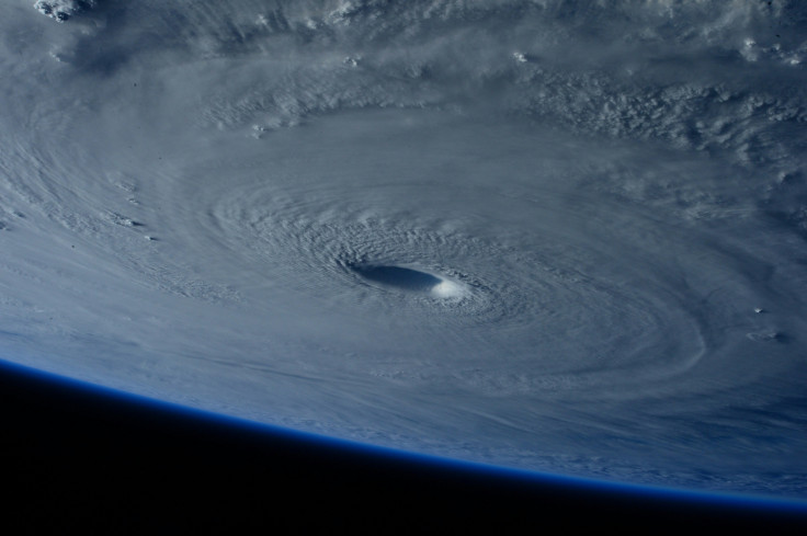
According to the National Hurricane Center, Humberto's winds roared to 160 mph (260 km/h) by late Saturday, making it the season's first Category 5 storm. At 11 p.m. AST (03:00 UTC Sunday), the hurricane's eye was positioned at 23.4° N, 62.1° W, or roughly 365 miles north of the northern Leeward Islands and 635 miles south-southeast of Bermuda, moving northwest at 13 mph.
While no landfall is forecast, Humberto's sheer size will generate life-threatening surf, rip currents, and large swells across the northern Leewards, Puerto Rico, the Virgin Islands, Bermuda, and the US East Coast starting early next week.
Meteorologists were stunned by Humberto's explosive growth, which saw the system leap from tropical storm to Category 5 in under 48 hours, driven by record-warm ocean waters and near-perfect atmospheric conditions.
At the same time, Tropical Depression Nine developed between Cuba and the central Bahamas. Packing 35 mph winds and drifting northwest, the system is expected to strengthen into Tropical Storm Imelda within the next day or two.
Current models suggest TD Nine could skirt Florida's east coast and then move toward the waters off Georgia and the Carolinas early this week. Heavy rainfall, gusty winds, and coastal flooding remain possible, and authorities are urging residents to monitor official forecasts closely.
Some meteorologists are also eyeing the possibility of a Fujiwhara effect, a rare phenomenon where two cyclones come close enough—within roughly 800 to 1,000 miles—to rotate around a shared centre, altering their tracks or even merging.
As of Saturday night, Humberto and TD Nine were about 940 miles apart, close to the range where interaction can occur. However, the National Hurricane Center has not included this scenario in its official forecast, stressing that confidence remains low.
Although Hurricane Humberto is not expected to make landfall, its Category 5 strength poses a significant threat through the dangerous surf and swells it will send toward the Caribbean islands, Bermuda, and the US East Coast.
Tropical Depression Nine, meanwhile, represents a more immediate concern for the Bahamas and the Southeastern United States, with the potential to bring tropical storm-force conditions, heavy rainfall, and flooding early next week if it intensifies as expected.
The 2025 Atlantic hurricane season has already proven volatile, and the simultaneous development of a Category 5 hurricane and a strengthening tropical system highlights the risks as the peak of the season continues.
© Copyright IBTimes 2025. All rights reserved.
- MOST POPULAR IN Trending