

Typhoon Hagupit weakens after battering eastern Philippines but authorities on alert

Typhoon Hagupit has weakened after battering eastern Philippines, but authorities remain on high alert over the potential devastation that could be caused by the tropical cyclone.
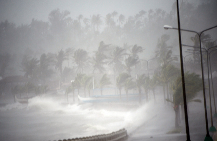
Though the tropical storm, locally known as Ruby, has weakened after making landfall, it is still packing winds up to 140kmph, said the Philippines weather agency Pagasa.
"At the moment [after affecting Masbate], we are expecting Ruby to traverse Romblon and probably Mindoro provinces before it moves to sea," said Pagasa's weather forecaster Chris Perez.
The storm is packing up to 170kmph gusts and the eye of the storm is moving towards west northwest at about 15kmph, after making its second landfall in Cataingan, Masbate, on Sunday.
"Manila is still far from the outermost diameter of the storm, but with the Amihan (northeast monsoon), we will already experience light to moderate rains beginning this afternoon," said Perez.
The storm is expected to make its third landfall on Sibuyan on Sunday between 20:00 and 22:00 local time.
Fear of a catastrophe – similar to the one caused by Typhoon Haiyan last year – has forced one of the largest ever peacetime evacuations in the country.
Authorities are well-prepared this time around after Haiyan pounded the disaster-weary country claiming more than 7,000 lives.
Speaking about the preparedness, Albay's provincial governor told the BBC: "That's what we've been doing, so our principal instrument to achieve zero casualties is essentially evacuation. It doesn't happen overnight so you need to train people. I feel confident we can achieve our zero casualty goal."
Hagupit has uprooted trees and ripped apart homes in many areas. Six major airports have been closed and more than 100 flights remain suspended. The real extent of the havoc is expected to be known only later.
© Copyright IBTimes 2025. All rights reserved.
- MOST READ


