

Typhoon Uwan: PAGASA Warns Its 1,400km Breadth Threatens Batanes to Bohol
Typhoon Uwan (Fung-wong) is a massive threat. Pagasa warns its 1,400km diameter will affect the entire Philippines. National alerts are now in effect.
Just weeks after Typhoon Tino devastated the Visayas and Mindanao, leaving a reported 188 people dead and a trail of destruction, the Philippines is bracing for another, even more massive threat. A tropical cyclone, set to be named Typhoon Uwan once it enters the Philippine Area of Responsibility (PAR), is currently churning in the Pacific.
But it's not just its expected Super Typhoon intensity that is alarming officials; it is its sheer size. According to the Office of Civil Defence (OCD) assistant secretary Rafael Alejandro IV, the potential storm's adverse effects are so widespread that they literally span the entire length of the Philippine archipelago—from Batanes in the far north to Bohol in the central Visayas.
This colossal reach means preparedness is not limited to one region but must be a truly national effort. This report summarises the devastating details, the warnings issued by state weather bureau PAGASA, and why the scale of Typhoon Uwan is a worst-case scenario for a nation still reeling from the recent catastrophe.
The Unprecedented Breadth of Typhoon Uwan: Batanes to Bohol
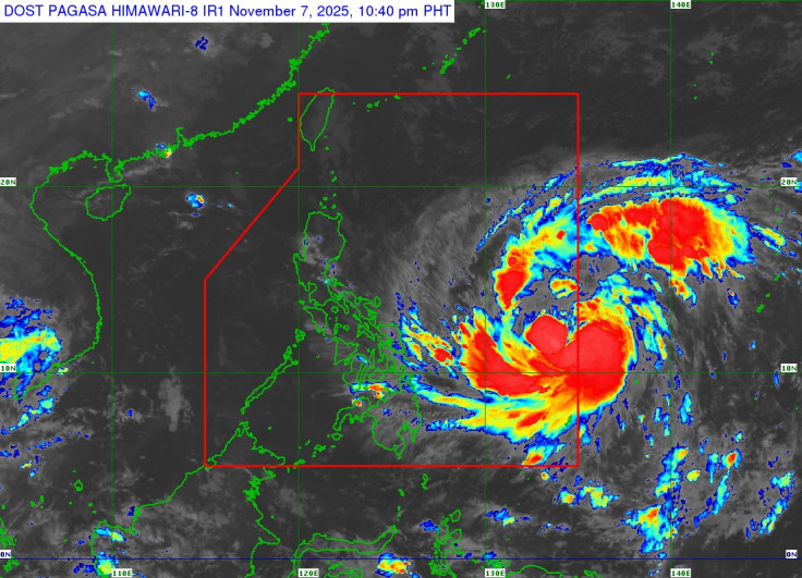
The primary, most alarming detail about the incoming storm is its massive size. Rafael Alejandro IV, assistant secretary of the OCD, shared the truly staggering measurement in a recent press briefing. He stated, 'Its 1,400-kilometre diameter – that is very big – could have an effect from Batanes to Bohol'. He stressed the severity of the threat, adding, 'This severe weather will have a widespread impact'.
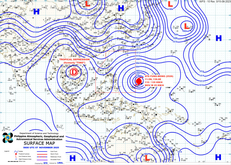
This incredible breadth means that areas traditionally safe from the direct path of a typhoon may still be significantly impacted by the system's outer rain bands and wind field. Batanes and Bohol are separated by approximately 1,200 kilometres, underscoring the necessity of nationwide disaster readiness. Typhoon Uwan, which is the local name for the severe tropical storm Fung-wong (meaning 'phoenix' in Cantonese), will be the 21st tropical cyclone to enter the country this year, according to the Philippine Atmospheric, Geophysical and Astronomical Services Administration (PAGASA).
The Imminent Threat: PAGASA's Forecast for Typhoon Uwan
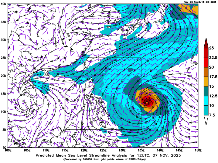
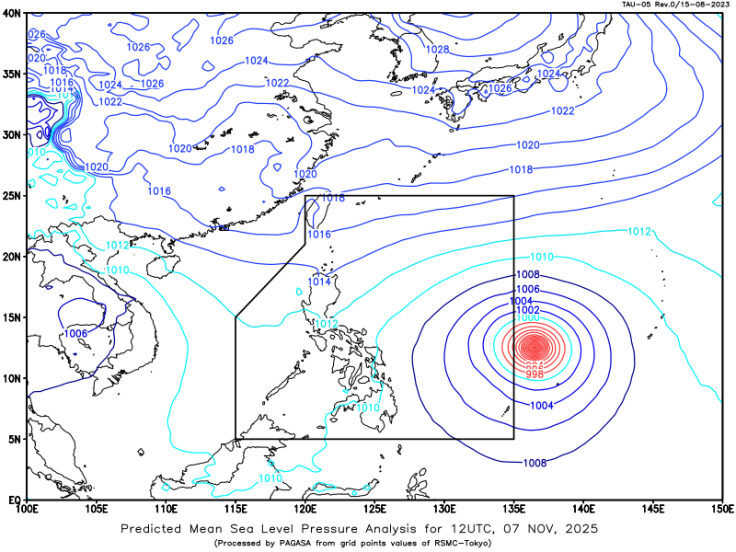
As of the latest reports, tropical storm Fung-wong was last located 1,315 kilometers east of Eastern Visayas at 11 a.m. on Friday. PAGASA forecasts that it may enter the Philippine Area of Responsibility either late Friday evening or early Saturday morning, upon which it will officially be named Typhoon Uwan.
The weather bureau has warned that the storm has the potential to rapidly intensify into a Super Typhoon (maximum sustained winds exceeding 220 kph) by late Saturday or early Sunday. Given the storm's projected path and intensity, PAGASA has raised Tropical Cyclone Wind Signal No. 1 over various provinces in Luzon, the Visayas, and Mindanao.
The highest possible alert level, Signal No. 5, may be raised over parts of Northern Luzon where the storm is increasingly likely to make landfall, bringing 'life-threatening winds' and severe weather. The current forecast track suggests Typhoon Uwan will continue moving west-northwest towards the Bicol region or Eastern Luzon, potentially skirting the Batanes and Cagayan area. The storm's passage, even if its centre is confined to one area, is expected to bring widespread, heavy rainfall.
High-Risk Areas and the Shadow of Typhoon Uwan
The vastness of the system translates directly into a massive number of communities placed at risk of hazardous weather. The Department of Environment and Natural Resources' Mines and Geosciences Bureau has identified a total of 8,164 villages across the affected regions as being susceptible to floods and landslides. Heavy rains and potential storm surges are the primary dangers, especially along the eastern seaboards of Luzon and the Visayas.
The sheer scale of this impending disaster is amplified by the fact that it comes immediately after the devastation wrought by Typhoon Tino (international name Kalmaegi). Tino left a horrific toll, with a reported 188 fatalities and 135 people still missing across the Visayas and Mindanao, with the province of Cebu bearing the heaviest loss. Typhoon Uwan threatens to hit Northern and Central Luzon particularly hard, but its immense size means it will further strain the already depleted resources of regions affected by Tino.
The Philippines remains extremely vulnerable to such storms as it lies within the western Pacific Typhoon Belt, where warm ocean waters and moist air create ideal conditions for tropical cyclones to form. In a disaster preparedness bulletin, the OCD explicitly warned that the storm's extensive reach could severely hamper relief efforts across multiple provinces simultaneously, necessitating a shift from regional to a multi-regional response strategy. The nation is now caught in a grim cycle of consecutive, catastrophic weather events.
Typhoon Uwan represents a maximum-scale disaster, not only due to its potential Super Typhoon strength but because its 1,400-kilometre breadth guarantees a truly nationwide impact, straining already depleted resources following Typhoon Tino. The official warning of a potential Signal No. 5 in Northern Luzon and flood risks in 8,164 villages demands immediate action.
If you are in the Philippines, monitor PAGASA updates religiously, secure your homes immediately, and follow all local government evacuation advisories. For those outside the affected zones, prepare to mobilise immediate relief and support efforts for the regions that will be simultaneously impacted by Typhoon Uwan.
© Copyright IBTimes 2025. All rights reserved.
- MOST POPULAR IN World


