

Scientists tracked commercial fishing in real-time and found over half the world's oceans fished
Scientists found that in 2016, 70,000 ships of the global fishing fleet travelled across 460 km.

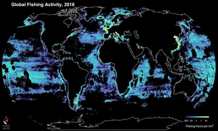
Commercial fishing activities around the world have been tracked by scientists in real-time. Scientists used satellites, machine learning and ship-tracking tech to shed light on the extent of commercial fishing worldwide.
Researchers found that over half the world's oceans, 55%, is now being industrially fished. That is around four times the land area that is covered by agriculture. The new research also found that in 2016, 70,000 ships of the global fishing fleet travelled across 460 km, almost the same as travelling to the moon and back to Earth 600 times.
The new study is the collaborative work of researchers from UC Santa Barbara, Global Fishing Watch, National Geographic Society's Pristine Sea project, Dalhousie University, SkyTruth, Google and Stanford University.
"I think most people will be surprised that until now we didn't really know where people were fishing in vast swaths of the ocean," the study's co-author Christopher Costello, a professor at UCSB's Bren School of Environmental Science & Management, said in a statement. "This new real-time dataset will be instrumental in designing improved management of the world's oceans that is good for the fish, ecosystems and fishermen."
The researchers believe that the total area of the world's oceans being fished may actually be higher than the estimated 55%. This is because the research did not include some areas with poor satellite coverage.
Using machine learning, scientists analysed over 22 billion messages publicly broadcast by vessels' automatic identification system (AIS) positions from 2012 to 2016. The Global Fishing Watch algorithm was not only able to spot over 70,000 commercial fishing vessels but was also able to determine their sizes and engine power. Besides, the scientists were able to identify what kind of fishing the vessels engaged in as well as narrow down the time and location of their fishing down to the hour and kilometre.
"This dataset provides such high-level resolution on fishing activity that we can even see cultural patterns, such as when fishermen in different regions take time off," said co-author Juan Mayorga, a project scientist in the Sustainable Fisheries Group at the Bren School and with NatGeo's Pristine Seas, Phys.org reported
Over 40 million hours of fishing was recorded in 2016. Researchers also discovered that most nations appeared to stick to their own economic zones for fishing. However, China, Spain, Taiwan, Japan and South Korea were found to be responsible for 85% of fishing on the high seas.
"Our analysis demonstrated that policies, cultures and economics play a huge role in driving fishing behavior," Costello said. "In addition, we examined whether fishing diminished when fuel prices were high and found a weak response. These are the kinds of things about which we've always speculated but haven't ever been able to test — until now."
The interactive real-time map tracking global commercial fishing has been made publicly available and allows anyone to observe where policy boundaries are being maintained.
"By making this data public, we are providing governments, management bodies and researchers with the information needed to make transparent and well-informed decisions to better regulate fishing activities and reach conservation and sustainability goals," Mayorga said.
"This collaboration opens up myriad research opportunities," Costello added. "We are leveraging the products developed by Global Fishing Watch to address new and important research questions that will improve fisheries sustainability around the world."
The new study has been published in the journal Science.
- MOST READ


