Tropical Storm Erin Hurricane Twist: Spaghetti Models Hint at a Surprise Track Change
Erin expected to strengthen into the season's first hurricane by Thursday

Tropical Storm Erin, the fifth named storm of the 2025 Atlantic hurricane season, is drawing increased attention after the latest spaghetti models revealed a split in possible future tracks. As of 5 p.m. AST on Monday, 11 August, Erin was located about 430 miles west-northwest of Cabo Verde, moving west at around 21 mph with maximum sustained winds of 45 mph, according to the National Hurricane Center (NHC). Central pressure was estimated at 1004 mb. Forecasters expect Erin to strengthen into a hurricane later this week as it continues across the central tropical Atlantic.
The NHC's latest advisory confirms no coastal watches or warnings are currently in effect. The storm remains well east of the Lesser Antilles, with its nearest point of approach still several days away. Forecast models suggest gradual intensification, potentially making Erin the season's first hurricane by Thursday. If strengthening continues as projected, Erin could reach category 2 strength over open waters by the weekend.
Spaghetti Models Show a Split
Spaghetti models, which display multiple computer-generated storm track projections, have begun to diverge significantly. Most models indicate that Erin will take a turn to the northwest, staying over the open Atlantic and avoiding land. However, a smaller cluster shows a more westerly path that could bring the storm closer to the Lesser Antilles by late week.
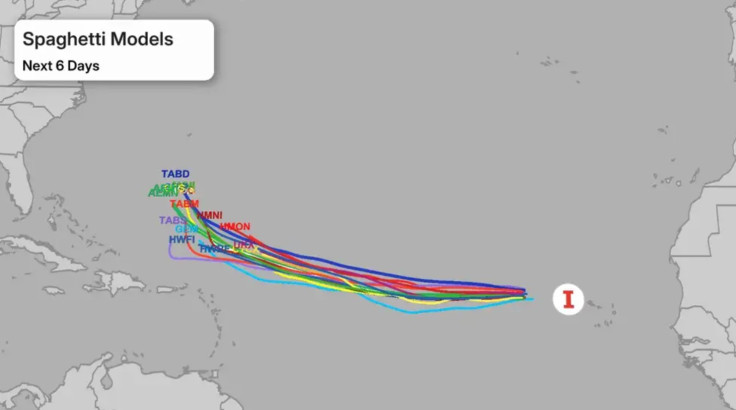
These differences are typical in the early stages of long-range hurricane forecasting. As reported by the NHC, forecast error margins can exceed 125 nautical miles by day four and up to 175 nautical miles by day five.
Why Forecast Models Disagree
Meteorologists point to several atmospheric factors causing the split in spaghetti models. The position and strength of the Bermuda High, a semi-permanent high-pressure system over the Atlantic, play a key role in steering tropical cyclones. Slight variations in this system's forecast position can shift a storm's projected path by hundreds of miles.
Additionally, mid-level troughs and upper-level winds are expected to interact with Erin later this week, adding further uncertainty.
Historical patterns show that similar Cape Verde storms — tropical cyclones forming near the Cabo Verde Islands — often strengthen significantly over warm Atlantic waters, but their eventual path depends heavily on the surrounding atmospheric setup.
Possible Scenarios Ahead
At present, there are two main scenarios for Tropical Storm Erin:
- Curving North into the Atlantic: The more likely outcome, based on current model consensus, has Erin turning northwest and remaining far from land.
- Continuing Westward: A minority of models suggest Erin could maintain a westerly track, increasing the possibility of affecting the Lesser Antilles.
The NHC has stressed that long-range forecasts are subject to change and that residents in the Lesser Antilles should monitor updates closely.
Official Guidance and Public Advisory
The NHC advises that no immediate threats to land exist but encourages the public to follow official updates as forecast confidence beyond five days remains low. According to the NHC, Erin is forecast to become a hurricane later this week, and its track will become clearer as model guidance adjusts.
Up-to-date information, including forecast cones and wind probability maps, is available through the NHC's website. Residents in potentially affected areas should review preparedness plans now and stay informed as the situation develops.
© Copyright IBTimes 2025. All rights reserved.
- MOST POPULAR IN World