Tropical Storm Tino: PAGASA Clarifies Path, Not Strength, Matches Yolanda and Odette
Typhoon Tino tracks towards Cebu, sparking Yolanda and Odette comparisons. PAGASA warns of heavy rain and strong winds.

Tropical Storm Tino's projected path sparked anxiety due to comparisons with devastating storms like Super Typhoon Yolanda (235 km/h) and Typhoon Odette (195 km/h).
PAGASA's Engr. Al Quiblat clarified the similarity is only about the storm's direction, not its strength. He firmly stated that Tino is not currently expected to reach super typhoon status or those past high intensities, though officials still urge high preparedness.
Residents in Cebu are bracing for a severe weather impact as a newly named tropical storm barrels towards the Visayas. Local government units have already activated disaster response teams, with Gov. Pam Baricuatro placing the entire province under high alert and ordering the pre-emptive evacuation of families in high-risk coastal and landslide-prone areas.
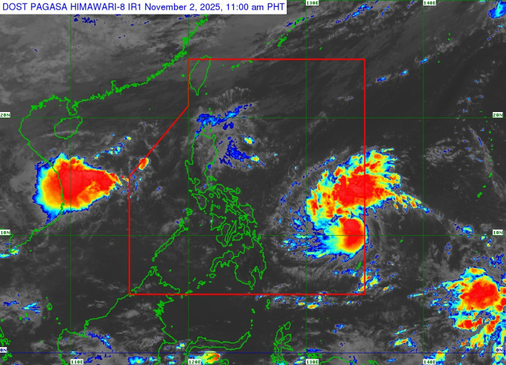
State weather bureau PAGASA has issued urgent warnings as the storm, now named Tino, intensifies, drawing unsettling comparisons to the destructive paths of previous typhoons.
The storm officially entered the Philippine Area of Responsibility (PAR) at 5:30 am on Sunday, November 2. It is the 20th cyclone to hit the country this year and the first of what PAGASA expects could be two or three tropical cyclones this November.
Heavy rains and strong winds are now expected to lash Cebu starting Monday, November 3.
How Tropical Storm Tino Is Intensifying And Its Projected Path
PAGASA is monitoring the system closely, which rapidly intensified in the early hours of Sunday. Maximum sustained winds jumped to 85 km/h from 65 km/h, with gustiness increasing to 105 km/h. This means Tino is already nearing severe tropical storm status and is forecast to strengthen further into a typhoon by Monday.
Engr. Al Quiblat, Weather Services Chief of PAGASA Visayas, explained they are monitoring two primary scenarios. 'It may approach northern Cebu or it may pass through Central Cebu,' he said. While the exact path remains within a 'cone of probability,' the forecast suggests a potential landfall in Eastern Visayas or CARAGA between Monday evening and Tuesday morning, November 4.
The 'Yolanda' and 'Odette' Comparison: What To Expect From Tropical Storm Tino
The storm's projected track has drawn comparisons to devastating typhoons like Yolanda and Odette. However, Quiblat clarified this comparison is about direction, not strength.
For context, Super Typhoon Yolanda (Haiyan) had maximum sustained winds of 235 km/h, while Typhoon Odette (Rai) peaked at 195 km/h before landfall. 'Tino' is not currently expected to reach these intensities.
'As of now, we haven't seen any scenario indicating that it will reach super typhoon status,' he stated.
While PAGASA noted a 'low chance' of it becoming a super typhoon, officials are urging the public not to be complacent. Quiblat warned that 'anything is possible' and residents must 'prepare for any scenario.'
'If we prepared for Odette, we should also prepare for this one,' he urged, noting that Signal No. 4 could be raised if winds exceed 185 kilometres per hour.
PAGASA has already issued rainfall warnings. Heavy to intense rain is expected over Eastern Samar and Dinagat Islands on Monday, with areas including Cebu, Leyte, and Negros Occidental facing the same intense downpour by Tuesday, November 4. Floods and landslides are expected.
The Philippine Coast Guard has grounded all sea travel in the affected regions, leaving hundreds of passengers stranded at ports in Cebu and Bohol. Residents in low-lying areas, particularly along riverbanks in Cebu City, have been advised to move to designated evacuation centres by Monday morning.
As Tino moves over the Visayas, it is forecast to pass directly over the waters of Lapu-Lapu City on November 4 before exiting into the West Philippine Sea. With the storm still strengthening over open water, all eyes are on the next three-hour bulletin.
© Copyright IBTimes 2025. All rights reserved.
- MOST POPULAR IN World