

Malaysia Airlines MH370: Aviation expert wants Australia to prove plane is in Indian Ocean


A military aviation technology expert has written to the Australian government to debunk its theory that missing Malaysia Airlines flight MH370 is lying in the southern Indian Ocean.
In a letter exclusively obtained by IBTimes UK addressed to Australian Prime Minister Tony Abbott, Foreign Affairs Minister Julie Bishop and Defence Minister David Johnston, Andre Milne, alleges the country's claims surrounding MH370 crashed into the southern Indian Ocean are false and amount to a "criminal act of fabrication of evidence".

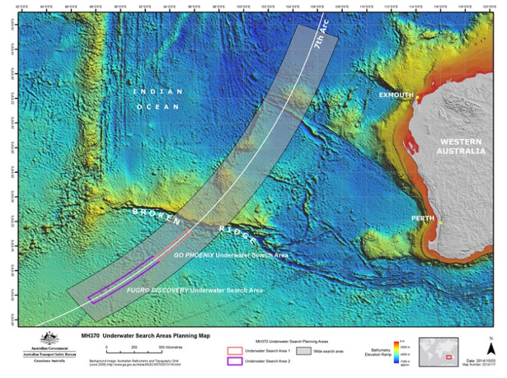
The official Malaysia report released earlier in March said the latest satellite data via British firm Inmarsat proved the plane flew for several hours before it crashed into the Indian Ocean on 8 March 2014. The airliner had mysteriously veered off its course from Kuala Lumpur to Beijing for reasons still not known. No distress signal was sent.
Malaysia Prime Minister Najib Razak at the time said it was believed the aeroplane's transponder, which emits an identifying signal was "deliberately disabled" before the plane changed direction and continued flying for a further seven hours.
The last communication between the plane and ground staff, where the pilot or co-pilot is heard saying: "Goodnight Malaysian three seven zero," happened at 1.19am.
But Milne on behalf of the victims' families is calling for additional answers by the Australian government to help fill in the gaps and prove its "seventh arc" theory that the Boeing 777, which had 239 passengers on board, is located in the Indian Ocean. He states the theory lacks "corroborative evidence".
"The families will not have peace until they get to the truth about what really happened to MH370," he said.
He outlines five facts to the Australia's Ministry of Defence that he alleges puts in doubt the current theory that the plane is in the southern Indian Ocean. He argues:
- not one piece of corroborative radar data to support your Artificial Incursion Theory has been produced by the governments of Singapore, Malaysia, Australia, New Zealand, United Kingdom all of whom as members of the Five Powers Defense Agreement have joint access to the Integrated Air Defense System that at all times had full command and full control of the very same airspace that you as Minister of Defence claim MH370 did trespass through illegally prior to then crashing into the southern Indian Ocean
- not one piece of corroborative radar data to support your Artificial Incursion Theory has been produced by the United States of America, the People's Republic of Indonesia, the People's Republic of Thailand and the People's of Republic of India – all of whom are signatory members of the United Nations, which operate multiple overlapping early warning aerospace threat incursion detection systems in the exact same airspace that you as Minister of Defence claim MH370 did trespass through illegally prior to then crashing into the southern Indian Ocean
- not one piece of corroborative radar data to support your Artificial Incursion Theory has been produced by the Jindalee system, [The Jindalee Operational Radar Network (JORN) is an over-the-horizon radar network that can monitor air and sea movements across 37,000 km<sup>2], that you as Minister of Defence is bound by parliament to ensure Australia is at all times warned in real time of any and or all acts of illegal aerospace trespass that your Artificial Incursion Theory allowed
- The single most extensive search operation ever conducted in human history involving; over one hundred ships, helicopters and sophisticated aircraft with advanced search and detection systems deployed by over 24 United Nations member states with a combined crew of over 10,000 highly trained professionals. Over one hundred million man hours of more than three million world volunteers searching and examining high-definition images captured by multiple satellite data systems released by a US based company called Digital Globe of the full perimeter of your Artificial Incursion Theory. Are all collectively unable to locate one single piece of aircraft wreckage and or any physical evidence that is corroborative in any way to your Artificial Incursion Theory?
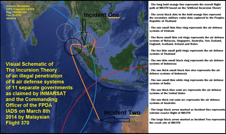
- The private contractor employed by the FPDA known as INMARSAT that released satellite data in regards to MH 370 did not include any of the data that would have been transmitted directly to the 24 hour per day monitoring technicians at Rolls Royce via the multiple self-contained sensors in each of the Rolls Royce engines upon MH 370 that would have detected in real time and then tramsmitted direct to Rolls Royce, the extreme changes in a) oil compression levels, b) atmospheric pressure levels, c) altitiude pressure levels, d) cabin pressure levels, e) fuel consumption levels that would have occurred at the specific moments of incident at the points on the attached Visual Schematic marked as Incident One, which is the moment of extreme evasive, and or counter evasive flight actions claimed by the FPDA IADS HQ at Base Butterworth and claimed in data by INMARSAT starting at approx 2:22 am lasting for a total of three minutes of time and marked as incident Two, which is the moment of exhaustion of fuel upon MH370 that occurred as claimed by INMARSAT, The Prime Minister of Malaysia, The Minister of Defence of Malaysia, The Prime Minister of Australia, and yourself as Minister of Defence, that occurred at the specific moment of the final transmission of data from the engines upon MH 370 to INMARSAT that occurred at approx 8:17am lasting less than one minute of time.
He demands the following requests from the Australian government to further prove their theory the airliner is in the southern Indian Ocean.
- corroborative data from Rolls Royce that synthesises perfectly with the specifics of incident One and Incident Two as located on the attached visual schematic
- a document of verifiable facts that explains why Inmarsat and the AAIB did not disclose the Rolls Royce data.
- a document of verifiable facts that explains why the data of Incident One that was disclosed by Inmarsat is of a three-minute incident when the extreme evasive flight action claims by the FPDA IADS would generate a minimum of 12 minutes of Rolls Royce data.
- a document of verifiable facts that details what transpired following Rolls Royce alarm detection of the event at Incident One on the attached visual reference.
- a document of verifiable facts that explains why the data of Incident Two that was disclosed by Inmarsat is of a multi second incident when the extended gradual descent of intersection with the Indian Ocean would generate between eight to 16 minutes of Rolls Royce data.
- a document of verifiable facts that explains why the multiple broadcast signal receives network Rolls Royce uses was not angulated to calculate the event of Incident Two being final trajectory arc drop to impact point.
- a document of verifiable facts that explains why the multiple radar systems of Indonesia was unable to detect MH 370 as it trespassed through the airspace of Indonesia.
- a document of verifiable facts that explains how the multiple radar systems of Thailand was incorrect in detecting an unknown aircraft from the last known location of MH 370 that was tracked by Thailand radar as flying direct to and landing at Airforce Base Butterworth
- a document of verifiable facts that explains how the advanced OTH radar system used by United States at Diego Garcia was unable to detect MH 370 trespassing Indonesian airspace, trespassing into the Australian JINDALEE system and then unable to pinpoint the crash site of MH 370 into the Indian Ocean.
- a document of verifiable facts that explains how the advanced OTH radar system used by Australia's JINDALEE was unable to detect and track MH370 trespassing the JINDALEE system and then intersecting into the Indian Ocean without generating hard data in real time of the exact time and site of the crash of MH370 on 8 March 2014.
In conclusion, his letter states: "Failure to refute and disqualify my submission validates my allegation that your claim MH370 exited Malaysian airspace to crash in the Indian Ocean is not only an Artificial Incursion Theory but a criminal act of fabrication of evidence."
Milne has since complained to Interpol to investigate what he claims to be a "clear violation of the protocols of Chicago Convention Section 25 International Civil Aviation Organ (ICAO) of the United Nations.
He wrote: "My investigative action suggests that a now documented pattern of corruption by unknown officials exists that is resulting in the premeditated fabrication of artificial claims and artificial evidence is being facilitated in an effort to create a cover up and or a diversion from the factual truth related to MH370.
"Primary motives for creating a cover up are a criminal act occurred during the flight and unfolded in such a way as to have negative impact upon the parties investigating and or associated with the investigative parties or an anomalous act occurred during the flight and unfolded in such a way as to be in conflict with legitimate issues of national security upon the parties investigating and or associated with the investigative parties."
IBTimes UK is waiting for a response from the Australia's ministry of defence and Interpol in response to Milne's letters. However, we have seen an acknowledgement from the office of Julie Bishop MP saying the matter would be brought to her attention. However nine months later, no other response has been sent to Milne about his concerns.
When asked where he thinks MH370 is located, Milne replied: "It is premature and utterly irresponsible to talk about any theory without having any physical evidence."
But he criticised the authorities for discrediting the findings of highly recognised scientific firm GeoResonance, which claimed the plane may have crashed in the Bay of Bengal. The firm had identified an aircraft wreck via its satellites, 190km south of the Bangladesh coastline and called the Australian Transport and Safety Bureau (ATSB), "ignorant" and "slanderous" at the time for not exploring it.
GeoResonance also questioned why Australian over-the-horizon radar did not detect the Boeing 777, given the theory that it crashed into the Southern Indian Ocean, and criticised Inmarsat for releasing only the data that confirmed its "seventh arc" theory instead of publishing all of the raw data to explore alternative locations.
"If it comes out in public that the aircraft is where GeoResonance said it was then you can also add insurance fraud to all the other charges against the parties involved," Milne said.

"If the plane went into the over-the-horizon radar we would know exactly where it hit the water. No doubt."
The official 584-page report on 8 March pointed to only one failing that the battery of the aircraft's underwater locator beacon had run out more than a year before and that there was no "unusual engine behaviour".
Bill Sullivan, a spokesman for Rolls-Royce, said there was no other data was transmitted from their engines after the ACARS (Aircraft and Communications Addressing and Reporting System) ceased transmission. "We concur with the findings of the report regarding our engines," he said.
The last ACARS transmission was sent via the plane's computers to computers on the ground at 1.07am but the expected 1.37am transmission was never sent.
No sign of the plane has ever been traced. It has been dubbed one of the biggest aviation mysteries of all time.
© Copyright IBTimes 2025. All rights reserved.
- MOST READ


