

Maui Fire Map Fails Again? Kaanapali Blaze Exposes Dangerous Gaps in Tracking System
Smoke filled the skies hours before any official evacuation alerts were issued
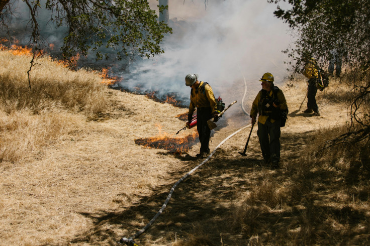
A fast-moving brush fire broke out in the Kaanapali area of West Maui on 4 August 2025, sparking panic among tourists and residents as smoke filled the skies before any official alerts were issued. The fire, which began near the old Sugar Cane Train warehouse above the Honoapiʻilani Highway, prompted sudden road closures and triggered growing concerns over the accuracy and timing of Maui's real-time fire tracking system.
Timeline of Events: Fire Spreads Before Map Update
According to a local report, the Kaanapali fire was reported at 11:40am on 4 August. By 12:22pm, both lanes of Honoapiʻilani Highway between Puʻukoliʻi Road and the lower highway were closed to support aerial firefighting. At 1:20pm, the Maui Emergency Management Agency (MEMA) issued evacuation orders, warnings and advisories for several zones due to smoke and proximity to the fire.
Despite these developments, it is unclear whether the Live Fire Map, operated by the Hawai'i Emergency Management Agency (HI-EMA), reflected the Kāʻanapali fire in real time. The timeline of the response has prompted public concern, as some tourists may have left after noticing smoke, before the evacuation advisory was even issued. However, no verified reports confirm this behaviour.
Real-Time Tracking Systems Called Into Question
The Live Fire Map is intended to provide real-time perimeter tracking and status indicators for wildfire activity. However, the system requires ground-level confirmation before events are displayed, which can delay updates during rapidly evolving situations.
Although no official report has confirmed a failure of the system during the Kaanapali fire, the timeline has sparked public concern over the responsiveness of Hawaii's wildfire tracking infrastructure. In the wake of earlier incidents, including the 2023 Lahaina disaster, experts and residents have highlighted broader issues with sensor coverage gaps and reporting delays, particularly in West Maui's high-risk zones.
Critics warn that such limitations may compromise public safety by delaying evacuation decisions and access to timely information.
Tourist Panic Mirrors 2023 Lahaina Disaster
The scene evoked memories of the 2023 Lahaina wildfire, in which delayed alerts and communication breakdowns contributed to the death toll and widespread Maui fire damage.
Social media posts captured the fear and confusion in real time. One TikTok user wrote, 'So you have any information on if it's under control? My babies are there visiting with their dad in Kaanapali for vacation. I'm so worried. I lived Makawao about 10 years ago... never had a fire while I was there 😔. I'm so sorry. 🙏❤️'
@ddamon Brush fire erupts this morning in Maui Hawaii 8/4/25 #maui #hawaii #fire #wildfire #fyp #fypage #foryou #fy #foryoupage #fypシ #fypシ゚viral #viral #viralvideo #viraltiktok ♬ original sound - damon silva
Another user expressed growing suspicion, commenting, 'These fires don't start themselves... what's going on!?!?' Meanwhile, a tourist feared for their belongings, posting, 'It might burn down my hotel — I'm really hoping my stuff doesn't get burnt.'
It remains unclear how local business owners received initial notice of the fire. There are claims saying that they relied on social media or informal alerts over official channels, but no direct accounts have been published supporting these statements.
Experts and Officials Respond to Fire Map Controversy
Hawai'i's Live Fire Map tracks wildfire activity but relies on manual ground confirmation, which can delay updates during fast-moving events. Concerns about its responsiveness have persisted since the 2023 Lahaina wildfire, prompting a 2025 After-Action Report calling for faster alerts, improved sensors, and automated data integration.
In a July 2025 briefing, MEMA said it is working with partners to implement faster detection technologies and more efficient alert systems as part of ongoing statewide reforms.
Fire Prevention Projects Underway Amid Scrutiny
Just days before the Kaanapali incident, Maui County launched a Wildfire Risk Reduction Project in the Ukumehame region, targeting 42 acres of high-risk land. The project involves clearing dry vegetation, abandoned vehicles, and combustible debris along the fire-prone Honoapiʻilani corridor.
Residents argue that the Kaanapali fire underscores the urgency of updating Maui fire maps and enforcing risk-mitigation measures before peak wildfire season. Many have questioned whether the recent fire could have been linked to neglected infrastructure in the area.
As of 5 August, fire crews continued to monitor hot spots, and no major structural damage from the Maui fire had been reported.
© Copyright IBTimes 2025. All rights reserved.
- MOST POPULAR IN World


