Storms In A Tango: Will Humberto And Imelda Spiral Into A Single Super-Hurricane?
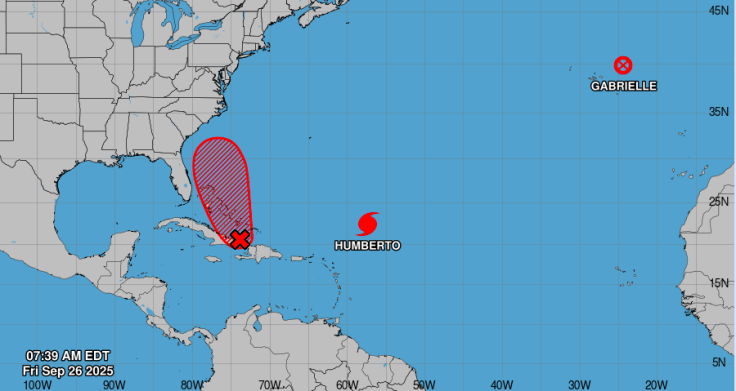
The Atlantic hurricane season has intensified with Hurricane Humberto and Tropical Storm Imelda swirling through warm waters, fuelling speculation about whether the two systems could engage in the rare Fujiwhara effect.
While meteorologists caution that the storms are unlikely to merge into a single 'super-hurricane', their proximity may still influence their paths and amplify risks along the US Gulf and East Coasts.
Humberto Gains Strength, Imelda Brings Flooding Fears
According to the National Hurricane Centre (NHC), Humberto has reached Category 1 status with sustained winds of 80mph as it tracks northward in the Atlantic. Meanwhile, Imelda has strengthened into a tropical storm over the Gulf of Mexico, bringing heavy rainfall and flooding risks to parts of Texas and Louisiana.
Meteorologists told CNN that while the two systems are not projected to merge into a single 'super-hurricane,' their proximity raises the possibility of an atmospheric dance that could alter their trajectories.
The National Weather Service has forecast rainfall totals of up to 15 inches in some areas. Houston officials have warned residents to prepare for flash floods and road closures, emphasising that Imelda's danger lies less in wind speed and more in prolonged rainfall.
What Is the Fujiwhara Effect?
The Fujiwhara effect occurs when two cyclones come within about 900 miles of each other, causing them to rotate around a common centre.
'Think of it as two spinning tops coming close,' hurricane researcher Phil Klotzbach of Colorado State University explained to The Washington Post.
'They can end up pulling on each other's circulation and changing their paths in sometimes unpredictable ways.'
Historical records from NOAA note that the last significant Fujiwhara interaction in the Atlantic occurred in 1995, when Hurricanes Iris and Humberto rotated around each other before separating.
Flooding Risk Looms Large for Texas and Louisiana
For residents along the Gulf Coast, the more immediate concern is flooding. Imelda is expected to dump up to 15 inches of rain in some areas, according to the National Weather Service.
Local officials in Houston have already warned of possible flash floods, urging residents not to underestimate the storm's impact.
In contrast, Humberto is forecast to remain primarily offshore, but its expansive wind field is expected to churn up dangerous surf and rip currents along the US East Coast.
The Miami Herald reported that lifeguards in Florida have been on high alert due to beachgoers ignoring warnings.
Experts Warn Against 'Super-Hurricane' Hype
Despite headlines about a potential 'mega-hurricane,' experts caution against exaggeration.
'The Fujiwhara effect is fascinating but rare in the Atlantic,' Michael Lowry, a hurricane specialist formerly with FEMA, told NBC News. 'More often than not, one storm weakens as the other dominates.'
The last notable Fujiwhara interaction in the Atlantic occurred in 1995, when Hurricanes Iris and Humberto--a different storm of the same name--rotated around each other before veering off on separate paths, according to NOAA historical records.
Instead, the pressing risks for Gulf residents are flooding, power outages, and strain on infrastructure. Along the East Coast, Humberto's broad wind field is already creating dangerous surf and rip currents, with The Miami Herald reporting lifeguards in Florida battling to keep beachgoers away from hazardous waters.
Climate Change and Intensifying Storms
Scientists say that while climate change does not directly cause hurricanes, warmer sea-surface temperatures provide more fuel for tropical systems.
'We're seeing storms intensify faster and drop more rain,' said Dr Kerry Emanuel of MIT in an interview with The Guardian.
'That means even weaker storms like Imelda can become destructive because of flooding.'
Stay Alert, Forecasters Urge
For now, forecasters stress vigilance. The NHC will continue issuing advisories every six hours on both Humberto and Imelda.
Officials across Texas and Louisiana have urged residents to prepare for power outages, swollen rivers and impassable roads, even if winds remain below hurricane strength.
As the two storms swirl in the Atlantic and Gulf, millions are watching to see if this rare meteorological dance could change the course of the season.
For coastal communities, the message from scientists is clear: focus less on the possibility of a 'super-hurricane' and more on the very real risks of flooding and high seas already on the horizon.
© Copyright IBTimes 2025. All rights reserved.
- MOST POPULAR IN World