Super Typhoon Uwan Update: TCWS No. 5 Zone Smashed By 185 km/h Winds, Eye In Nueva Vizcaya
Super Typhoon Uwan made landfall in Aurora, striking Luzon with 185 km/h winds. The storm is now traversing the mountains, bringing storm surge and TCWS No. 5 threats.

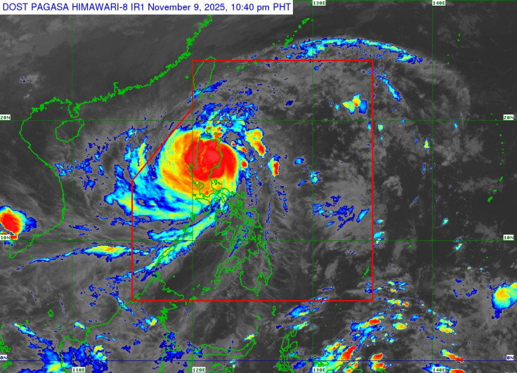
The sound of the roaring wind now echoes across the Philippine mountains. The catastrophic core of Super Typhoon Uwan, known internationally as Fung-wong, has plunged into the heart of Luzon, unleashing a torrent of destructive winds and life-threatening storm surge upon millions of residents.
Following its landfall over Dinalungan, Aurora, the typhoon is now engaged in a brutal traverse across the rugged terrain of Northern Luzon, dragging the highest threat level—TCWS No. 5—over densely populated regions.
The danger is immense, with the latest update showing the eye of the storm situated in the vicinity of Kasibu, Nueva Vizcaya, where sustained winds remain at 185 km/h and gusts hit 230 km/h.
With the wind field extending outwards up to 900 km, the entire northern half of the country must now prepare for a night of survival, as the Super Typhoon Uwancontinues its destructive, slow-motion rampage.
Super Typhoon Uwan: Eye Traverses Northern Luzon
The core threat of the storm is now inland. After making landfall over Dinalungan, Aurora, at 9:10 PM tonight, the eye of the Super Typhoon Uwan was estimated to be in the vicinity of Kasibu, Nueva Vizcaya, as of 10:00 PM. The storm is moving northwestward at 30 km/h.
Despite beginning its interaction with the terrain, the storm retains its devastating intensity, with maximum sustained winds of 185 km/h near the centre.
The areas under the most severe danger, TCWS No. 5, facing "Extreme threat to life and property" from typhoon-force winds of 185 km/h or higher, now include:
- The northern and central portion of Aurora (including Dinalungan and Baler).
- The southeastern portion of Nueva Vizcaya and the southern portion of Quirino.
- The northeastern portion of Nueva Ecija.
Directly surrounding this are regions under TCWS No. 4, facing 'Significant to severe threat to life and property,' a zone that now includes almost the entirety of Ilocos Sur, La Union, Pangasinan, Isabela, Mountain Province, Ifugao, and Benguet.
This vast area of extreme wind and heavy rain is due to the storm's massive wind field, which reaches up to 900 km from the centre.
Super Typhoon Uwan: The Storm Surge and Forecast Track
The hazard warnings are clear: the storm's path across Northern Luzon is expected to continue throughout the night and into tomorrow morning.
The storm is forecast to emerge over Lingayen Gulf or the coastal waters of Pangasinan or La Union tomorrow morning.
- Weakening Trend: The interaction with the rugged terrain of Northern Luzon is forecast to cause Super Typhoon Uwan to 'weaken significantly,' however, it is expected to remain classified as a typhoon throughout its entire passage over Northern Luzon.
- International Track: The typhoon will turn northwestward to northward tomorrow, remaining at the typhoon category until Tuesday. By Wednesday, it will turn northeastward towards the Taiwan Strait, where it is forecast to make landfall over western Taiwan on Thursday, before rapidly weakening.
Coastal communities face immediate danger from the sea. There is a 'high risk of life-threatening and damaging storm surge with peak heights exceeding 3.0 m' within the next 48 hours.
This risk spans low-lying communities across a huge swathe of the country, including Central Luzon, Metro Manila, CALABARZON, and the Bicol Region.
Mariners face extremely dangerous conditions, with a Gale Warning in effect across the seaboards of Luzon and the Visayas. Waves of up to 14.0 m are expected in the seaboards of Isabela, Aurora, and Camarines Norte.
Sea travel is 'risky for all types or tonnage of vessels,' and all mariners are strongly advised to remain in port. The public is urged to follow evacuation and other instructions from local officials immediately, as the window for safe action is rapidly closing.
© Copyright IBTimes 2025. All rights reserved.
- MOST POPULAR IN Trending