

Winter Storm Hercules: Flights Cancelled as US East Coast Prepares for Freezing Snow Blast

Airlines have begun to cancel flights to the east coast of the US ahead of winter storm Hercules, the first to hit the northwest of the country this year.
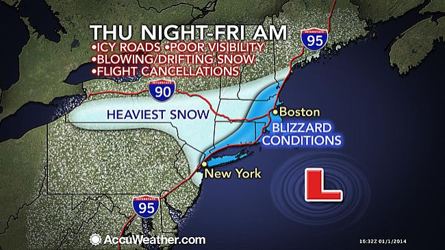
Hercules is expected to dump up to 14 inches of snow on Boston and a further 10 inches on New York, with freezing temperatures and strong winds predicted.
Speaking to the New York Post, AccuWeather meteorologist Mark Paquette said: "It's going to be right around freezing on Thursday but that's going to feel mild compared with Friday. You get the snow, then you get the cold and the wind, making it really miserable."
Snow has already started falling over New York and New England, with the full force of the storm expected to hit tomorrow (3 January) and into the weekend.
Hugh Johnson, a meteorologist with the weather service, said: "There will be travel problems."
Flights from London to New York and Boston have been cancelled, with services run by Virgin Atlantic and British Airways currently affected.
Hundreds of flights into and out of Chicago's O'Hare International Airport have been cancelled, while New Jersey's Newark Liberty Airport has been badly affected.
Some schools in New England and New York have been closed pre-emptively or have planned early dismissals. Homeless shelters are also preparing to work at full capacity.
"In addition to the snow threat, there should be some coastal flooding at high tide for the east coast of New England due to strong onshore winds."
The severe weather has already been responsible for one death after a truck driver died when he crashed into a bus on a snow-covered highway in Rolling Praire.
New York Governor Andrew Cuomo suggested people take public transport to work rather than drive as a safety precaution. "We are looking at a serious storm situation," he said.
The Weather Channel said a blizzard warning was in place for Long Island, the south shore of Massachusetts, and Cape Cod: "An initial band of light-moderate snow Thursday from New York state and northern Pennsylvania to New England will give way to a more expansive area of snow by Thursday afternoon and evening over much of the Northeast from West Virginia and Maryland to southern Maine," it said.
"Given widespread temperatures in the teens and 20s, this will be a relatively dry, powdery snow with an added 'fluff factor' – meaning deeper snow accumulations than you'd see from a wetter, gloppier snow. Toward the later stages of this snow event, temperatures will plunge even further on Friday, possibly flirting with zero in areas away from the immediate coast.
"In addition to the snow threat, there should be some coastal flooding at high tide for the east coast of New England due to strong onshore winds Thursday and Friday. Beach erosion and flooding of vulnerable coastal roads can be anticipated along with freezing spray from breaking waves."
© Copyright IBTimes 2025. All rights reserved.
- MOST READ


