

UFO Researcher Claims Seabed Data Shows a Sunken Ancient City Resembling Atlantis in the Atlantic
A UFO researcher claims Seabed 2030 data shows an ancient city near the Bermuda Triangle, but scientists disagree
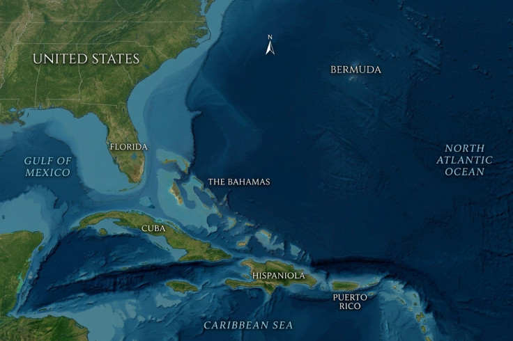
A UFO researcher claims that patterns in seabed mapping data could be the remains of a sunken ancient settlement near the Bermuda Triangle.
The claim is unverified, and no independent scientific or archaeological evidence has been identified to establish that the apparent formations are man-made structures.
Scott C Waring, a self-described UFO researcher, argues that the geometric patterns could represent an intelligently constructed settlement built by ancient humans or, he speculates, by another civilisation.
His interpretation has attracted attention because the alleged site is located in an Atlantic area frequently linked to Bermuda Triangle folklore, although the term itself has no official boundaries.
What Waring Says He Found
The claim followed Waring's examination of bathymetric mapping data associated with Seabed 2030, a global project intended to advance comprehensive mapping of the world's ocean floor by 2030.
Bathymetry concerns measurements of seafloor depth and terrain, meaning the material at issue is mapping data rather than underwater photographs or direct visual evidence of buildings.
Waring said he spotted faint, intersecting and roughly parallel lines in seafloor mapping data off Cuba and Haiti. He estimated that the apparent pattern extends for roughly seven or eight miles, or around 11 to 13 kilometres, in one direction and about three miles, or five kilometres, in the other.
The dimensions are Waring's estimate of what he sees in the data rather than independently surveyed measurements of an archaeological site. He argued that the lines appeared too regular and symmetrical, in his view, to be natural formations.
In a video discussing the map, Waring said the geometric patterns indicated something he believed had been intelligently made. He has suggested that the supposed layout resembles streets, foundations or other organised features, though those descriptions remain his interpretation of the mapping pattern rather than a finding endorsed by Seabed 2030, GEBCO or a marine-science institution.
Ancient Humans or Aliens?
Waring initially raised the possibility that the alleged formation might be connected to either ancient humans or extraterrestrials. He later said he favoured an ancient-human explanation, writing that the design looked more 'primitive and less futuristic' than he would expect from an advanced non-human civilisation.
He compared the alleged site with Atlantis, the legendary island described by the ancient Greek philosopher Plato. However, Atlantis has not been established as a historical place, and Waring's comparison does not amount to evidence that the legend was based on a real civilisation.
Waring has also speculated about how such a settlement might have become submerged. He suggested that, if the lines do represent an ancient settlement, it may have been built on or close to a coral reef before an earthquake destabilised the area and caused it to sink.
That scenario remains hypothetical and depends on the unproven premise that the mapped pattern represents a settlement in the first place.
Limits of Seabed Mapping
Global bathymetric grids are valuable scientific resources, but they are not the same as a detailed archaeological survey of every part of the seafloor. Such datasets can incorporate direct ship-based sonar measurements alongside satellite-derived information and interpolated estimates, particularly in places where high-resolution survey coverage is limited.
As a result, the apparent resolution of a terrain model may differ from the resolution and density of the measurements underlying it. This does not mean that every geometric-looking feature is an error, but it does mean that a pattern visible in a broad mapping grid cannot, by itself, demonstrate the physical presence of roads, walls or buildings.
Available reports do not identify independent scientists, marine archaeologists, or geological institutions that have confirmed the lines near Cuba and Haiti as artificial structures. Nor is there any identified physical evidence, such as worked stone, pottery, tools, foundations, or underwater imagery, linking the location to an ancient human settlement.
Establishing whether the pattern has an archaeological explanation would require further investigation. That could potentially include targeted multibeam sonar work, higher-detail mapping, remotely operated vehicle footage, underwater photography and archaeological assessment of any material found at the site.
Bermuda Triangle Mythology
The alleged location has prompted comparisons with the long-running mythology surrounding the Bermuda Triangle. The loosely defined Atlantic area has been associated for decades with stories of missing ships and aircraft, as well as claims involving unusual compass readings.
However, the Bermuda Triangle is not an official geographic designation and does not have universally recognised boundaries. NOAA says there is no evidence that mysterious disappearances occur more often there than in other large, heavily travelled areas of ocean.
Accounts of unusual compass behaviour are also often overstated in popular retellings. A magnetic compass can sometimes align with true north rather than magnetic north in particular locations, but this is a known navigational phenomenon rather than proof of a paranormal anomaly.
The western Atlantic can present genuine risks, including storms, rapidly changing weather, strong currents and heavily travelled maritime and air routes. Those realities offer more grounded context for the incidents that helped create the Bermuda Triangle legend.
For now, Waring's claim remains an unverified interpretation of patterns in publicly available seafloor mapping data. The apparent features have not been established as archaeological structures, and further scientific investigation would be needed before they could reasonably be described as the remains of a lost city.
© Copyright IBTimes 2026. All rights reserved.