

Typhoon Uwan Update: Terrifying Videos Show Monster Storm Smashing Into the Philippines
KEY POINTS
- Nearly one million residents evacuated as Super Typhoon Uwan hits Luzon
- PAGASA warns of storm surges up to three metres and waves reaching 14m
- Over 30 million people exposed to Uwan's path, authorities urge vigilance
Terrifying videos have emerged online showing the sheer power of Typhoon Uwan, internationally known as Fung-wong, as it tore through the Philippines with devastating force.
The Category 4 storm made landfall overnight in Aurora Province, bringing winds of up to 230 kilometres per hour and torrential rainfall that triggered widespread flooding and power outages.
The typhoon's massive circulation, spanning more than 1,500 kilometres, battered large portions of Luzon, forcing nearly a million residents to evacuate from coastal and low-lying areas.
The landfall came just days after the country was struck by Typhoon Kalmaegi, which left 188 people dead, compounding fears of prolonged devastation.
Viral Videos Capture Widespread Destruction
Videos shared across X (formerly Twitter), TikTok, and Facebook captured the terrifying reality faced by communities in the storm's path. In Catanduanes, clips showed giant storm surges swallowing beachfront homes and vehicles being swept away by rising waters.
@gmanews Strong waves battered coastal areas in Barangay J.M. Alberto, Baras, Catanduanes, morning on Sunday, November 9, 2025, as Super Typhoon #UwanPH triggered a storm surge that flooded several seaside areas. Video courtesy: Dannylyn Manalo via Vincent John Abordo/GMA Regional TV News
♬ original sound - GMA News
@gmapublicaffairs SIGNAL NO. 5 SA CATANDUANES Sinalubong ng malalakas na hangin at ulan ang mga taga-Virac, Catanduanes kaninang 9 AM, Nov. 9, bunsod ng Super Typhoon Uwan. 📷: Philippine Red Cross
♬ original sound - GMA Public Affairs
In Quezon and Camarines Norte, residents filmed rooftops being torn off as power lines collapsed, plunging entire towns into darkness.
@gmapublicaffairs SUPERTYPHOON UWAN, NANANALASA NA RIN SA QUEZON Nakakaranas na ng malakas na hangin at pag-ulan ang mga taga-San Francisco, Quezon Province dulot ng Bagyong Uwan. Sa kasalukuyan, nakataas na sa Signal No. 4 ang lugar. #FYP ♬ original sound - GMA Public Affairs
@gmapublicaffairs TINGNAN: TULAY SA CAMSUR, HALOS MAPATID NA SA PAGWASIWAS NG HANGIN! Sa lakas ng hangin at ulan, halos mapatid na ang tulay na ito sa San Jose, Camaligan, Camarines Sur bunsod ng bagyong Uwan, Nobyembre 9, 2025. Binabantayan din ng mga residente ang kalapit nitong Camaligan River na malapit na ring umabot sa Critical level ang tubig. #FYP "'Pag nasira po ang tulay, wala pong choice kun'di ikutin yung kabilang barangay para makatawid," Kuwento ni Fronie, residente ng lugar. #FYP
♬ original sound - GMA Public Affairs
@gmanews Itinumba ng napakalakas na hangin dala ng Bagyong Uwan ang ilang poste ng kuryente sa kahabaan ng Bagasbas Road, Daet, Camarines Norte. Nagliparan din ang mga kable ng kuryente. Ilang sasakyan at tricycle tuloy ang nakipagpatintero sa mga kable at natumbang poste. | via Darlene Cay/GMA Integrated News
♬ original sound - GMA News
The hashtags #TyphoonUwan and #UwanPH continue to trend globally as more footage surfaces.
Forecast and Continuing Dangers
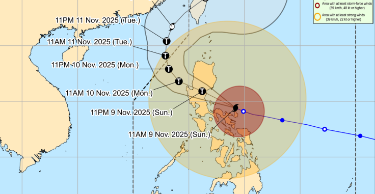
As of 2:00 pm (Philippine Standard Time) on 9 November 2025, the Philippine Atmospheric, Geophysical and Astronomical Services Administration (PAGASA) reported that Super Typhoon Uwan (international name Fung-wong) was located about 100 kilometres northeast of Daet, Camarines Norte.
The system was moving west-north-west at around 30 kilometres per hour, packing maximum sustained winds of 185 kilometres per hour near the centre and gusts reaching 230 kilometres per hour.
PAGASA warned that Uwan poses a high risk of life-threatening storm surges exceeding three metres along the eastern seaboard, affecting coastal areas in northern and central Luzon including Aurora, Isabela, Cagayan, and Bicol.
Seas in these regions are expected to remain extremely rough, with waves reaching up to 14 metres. Authorities have advised all vessels to remain in port until conditions improve.
The typhoon's rain bands continue to bring intense rainfall to large portions of Luzon, raising the likelihood of flash floods and landslides, especially in mountainous terrain.
Areas under Wind Signal No. 5 are forecast to experience widespread structural damage, fallen trees, and power interruptions as the system moves inland.
According to PAGASA's forecast track, Uwan is expected to make landfall late on 9 November or early on 10 November in the central portion of Aurora Province before crossing northern Luzon and possibly emerging over the Lingayen Gulf by the following afternoon.
The typhoon is projected to weaken slightly as it interacts with mountainous terrain but will remain dangerous due to its wide circulation and intense rain bands.
Residents in affected areas are urged to remain indoors, avoid coastal and low-lying zones, and comply with evacuation orders issued by local authorities. Those in regions under the highest wind signals have been warned that evacuation may no longer be safe due to deteriorating weather conditions.
Even after the typhoon's centre moves away, overflowing rivers and saturated soils will continue to pose serious risks to communities already hit by flooding from earlier storms.
International Attention and US Monitoring
The US Embassy in Manila issued an advisory urging American citizens to follow local evacuation orders and monitor government updates.
American storm chaser Josh Morgerman has been documenting the typhoon's progress from within Luzon, sharing real-time updates on social media platforms.
Monitoring agencies, including the Japan Meteorological Agency and the Joint Typhoon Warning Center, continue to track Uwan's movement as it heads northwest.
Analysts note that the storm's rapid intensification aligns with recent global patterns of stronger tropical cyclones linked to warming sea temperatures.
© Copyright IBTimes 2025. All rights reserved.
- MOST POPULAR IN World


